press ctrl and + to see larger images
DEDICATED TO THE FIRST CITY-MUMBAI-[BOMBAY] ;OF INDIA.
BOMBAY FORT AND HARBOUR


Aerial View of Ballard Pier Bombay, Old Photo 1930
Glimpses of old Bombay and western India, with other papers (1900)
1709 BOMBAY STORM,NEPTUNES RITES FOR CROSSING THE EQUATOR,PASSPORT MADE COMPULSORY FOR TRAVEL,BEHEADING OF DACOITS,CARACHEE(KARACHI)A DESOLATE PLACE,
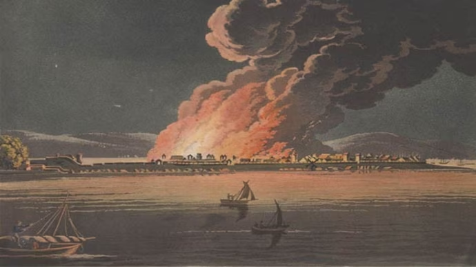
The night of November 4th, 1709, was one long re- membered. A storm blew with terrific violence, and, when day broke, a spectacle of appalling ruin was revealed. The shore from the bunder-head to Mazagon, far as the eye could reach, was piled with wrecks.

Under Hornby's Battery, round the Castle sea face, as far as Fort George, were great heaps so completely dashed to splinters that not a trace could be discovered of any individual ship. The Resolution,, sliip of war, went to pieces under the Castle walls, and more than 100 craft and 500 lives were lost.
In 1802 a young man of the name of Maw arrived by the Scales!) 1/ Castle, and immediately raised an action against Learmonth, the commander, for the hard treatment he had experienced during " Neptune's rites " on crossing the Line, having been soused, and shaved with dirty water, and otherwise tumbled about by the officers and sailors. The captain was fined Rs. 400. Fines like this soon put an end to the custom.
BEGINNINGOn August 12th, 1799, Government ordered that no European should travel without a passport.
But, with or without a pass, four officers, in 1800, crossed over the harbour to Pan well, and proceeded to Chowk, twelve miles. Here a surprise met them. At a turn of the road they beheld six headless men suspended by the legs from a tree — dacoits,

Tantia Bhīl, a famous dacoit.
.suspected of waylaying treasure from Poona. The Peishwa's amuldar had settled the matter by cutting off" their heads ! Without mentioning Matheran, they note that it was " a beautiful country of hill and dale."
Another adventurous individual made his way, the same year, to " Carachee." There he found a population of 10,000, mostly in mud huts, and a fort garrisoned by twenty men, " conspicuous by their poverty and insolence." Think of this, ye Sindians, driving to-day to Clifton, and of the other fact, illustrative of the insecurity of life and property in these dry and sandy regions, " even the shepherd tending his flock is accoutred with his gun, scimitar, shield and dirk."
ONE YEAR TO TRAVEL TO ENGLAND OVER LAND BY BAGDAD On January 1st, 1800, Colonel Dow obtained leave to proceed to Europe " overland," which meant in those days via Bagdad, as Colonel Hartley had done in 1781, taking a year to make the journey. *
BOMBAIA (BOMBAY IN PORTUGUESE)-16TH CENTURY ENGLISH FORT IN BOMBAY


Below:-The Fort, Bombay, Harbour face wall,-GUNS POINTING DOWN
INTO MOAT 1863.--Date: 1863--Photographer: Unknown-


old Mumbai | Window To India
windowtoindia.wordpress.com
FORT BOMBAY WITH FORT WALLS 1850
![BOMBAY FORT MAPS,PHOTOS,PAINTINGS,NEWS.1600 T0 1870 | Bombay Photo Images[ Mumbai]](data:image/jpeg;base64,/9j/4AAQSkZJRgABAQAAAQABAAD/2wCEAAkGBxMSEhUSEhIWFRUXFxUVFRcXGBcVFRcVFxUXFxUVFRUYHSggGBolHRUVITEhJSkrLi4uFx8zODMtNygtLisBCgoKDg0OFRAQFy0dHR0tLS0tLS0rLS0tLS0tLS0tLSstLSstLS0tLS0tLS0tLS0tLS0rLS0tLS0tLS0tLSstLf/AABEIAMABBwMBIgACEQEDEQH/xAAaAAACAwEBAAAAAAAAAAAAAAABAgADBAUG/8QAPBAAAQMCBAMFBgUCBQUAAAAAAQACEQMhBBIxUQVBYRNxgZGhIjJSsdHwBhRCweEV8VNicpKiIyQzQ4L/xAAYAQEBAQEBAAAAAAAAAAAAAAAAAQIDBP/EAB8RAQEBAAICAwEBAAAAAAAAAAABEQISITEDE1FBYf/aAAwDAQACEQMRAD8A94lJTIFed0BFBQICigEwVERhQIwgVRMlhUBBFBBEpRUKilURhBAZRSpgFBAiiAo9shFEBGFRSaQtdRqUhWiQiphhAlGFloFE0KQooIhSFAERFEVEARlBRQMCgoAogoAQITAKLq5lDVITKIFhMoiAgkJkAFY2mSgSEHNWgUlMoCauMrmHZKQtLnpHv6JpinJ0UyJySq3uQEoQgX8lZCikDU4CaEYU0LCj7BOAleyUUlPWStTmyFmLeQWltghC6WARpthWHRKSoqtRNCCipCiiigigRCgQCFIRhGEEAQTtCiIylRHKnp05XVzVowr+yCIAGl1NXCMpz0R7MJyJ+7KSB1Ua8CymEz+irLkIVQHOO6QhWEKQgqLVMqsyqZUFTmrNUbC2PsJWR7STMJEpc1rKykSqja0K91WBZKRdlUhIytPJXwstaSEUUHOhFV1ANVbTEqkNWlrYCUiEoJg1BRQhCEyCAIwma1NCgrhEBFQBFCEYRhGEQAFE4CCCqAOqhqbBAhALbKEkoSo58J6ZBCqEKICd1PmhChiBMAgAnCLgZUCE6EIFIUKj3Qi1wQKQqcSLWWhw20Sv0Qcx6YNTVCgHLTK1jNir6Lt1VRKuqNkTClWGc3ZTIHCVKKtYFGlVKmrgFHJWu5KAVSIKqpnU+ilYzZIwoL2BTLdFg3TDVZUCEESpCgEIowpCKgRAUCMIghREKIMhxUT6KsYieSxvfZIHrtjnrVVqqyi8Fc+UzakKYa7DSo0Lnsrx4q+nXTF1pTNWarVnRBrymGthUjqsTqpQFVMNaarFkqFW1MTZUOKsSi6pCLq9lS8qSlWUrymaEparGNRFrWrXT0VdMK4BZrUBrU6gUcoqqo9ZwVoLZUFLmgpY1Xsp2UATKWkiKBRFRoEVFFBFAojCggTQgiiDCKiKo860oQhnRFRd45AQl6JnFJmQWMKtFTZZy7ZQOQau0VmdY891cSguLlU9yR52SlyBzURc9UErTRAIJIsAe7NyClqyaUlQpSFaxNQzArWtT0WArT2QWdbLTVqDQAi4rOqCjiq3uUpmUVagQoooFATQioooIhFRAAEYRUCIEIwioihCYKIoiBREKKjyx3P3snrUy0lZsPTa4uLy79LWDS9ySANdF0nkGc2p1N58FfsidGHPukOIZujjmezIcGgyBNySNriNF5+pVIt6hXtvpLxx3hiGgFz3ZWzDWj3nHqeQ7lvdhyRJidhy8ea8rg6hIgm3VekZizrLZPKxA253WbbFklAtRkrFw6u8VCx/tZpINjfcdOi2Yt4AGYloJibfNb74z0c7HY0tdFwB93Qp49wgm4VXEsG+M4JLRvM9Vjputc/speX4df13qeKY64mO5aQZEjS/yKwcHrAN9w66hB2Le55AIFiIgwOvf16qTkvVsxmNbTgG5PIa/wAJzxGmyMxMkA5W+0b8p0lU1OHsLYdLnG5cfemOWyw4TDljyHCYFnffNT7IvSvT4Su1wsCDsYn0WiVw6VSDImdUXfiJnJjvQKS6tmO4Skc5UYPE9oJjKdYmTHJXoI0JwlRBQMiklEFRTKBAFRAyiWVAoHCkpVFQ0oyklMEBlEIBFAyCgUWkeE/P1M7Xig/2S6RlMOkEAzHVWcU4jWcW5Kb2j9UA6x3aarUGlsNJuZjrGoVNWtLYBIJOQG9nbFc+0301JccoUa73RlcAebg6Aetle7hTzE5rHbXxRNV8uaagBBvY8xNuiWpWqscxvaWeCQYtYTGmwW5yZ6rMThqhptcWAEZpAGgAEOO/PyXpWvaxrS91nZA0EcyBa3dK846vVax7s4eIg20k63G0q2jVe8BpqBxlrm2Igi9rbJbLFksdGrhXNrh5IjJBOl4ImB3pOK4c1GQCJBm89fqs9LHk5pcJHsmZJBgaQOqd2OIcGudcgkdQI271i3y1jLW4dUdSDZGYEwJgQVh/pFYAlwAjqPDS8rsVMRDJLzFhM3vbnzuuBxzj5bNP2u8kgkzE2ItqrLb6Syf1lxHGC1rqTRc6kzy5RMDvWHAY51NweCbGTeZAXGrVJuDN/G6vw9URe3dOh8e5dLxyMyvQ4z8V1XQLN1uAb7IYfjlUAS6edxr3FcOrTDtJN5EdBrCFCsPddETzjmfKeqx1meDbr1fDMQ6q6DUcL3Ga8TeIK7AwLRUBAkTPTyXhTiXUycoAO9l6HhOPD2xUkv6EadRCvkd+vVeHEtmO/pdUUuLEkAZiSYF/5S4Z1F8jPDhMtJH7hGngadMh7XCeXunW0ysyyeFy3y6tGs7mTfr8kX4l2oNpjULHVqAQRB8UoxI2t+/ms7fbWR12Y74mxy1BTjGCYgz4fVcgYk8h8/qn/MnnEeMpt/DI6NXijGmHZhtYme6E1HiVN3uknwXHrPzASLjTX6qqnUDfdbHifqtS/qY9B+db18kDjW8pXFz71C3pr4/NMKjZ/wDI7nv9FO0Mrs08aIvM9yY4xvVeexdY27N50Mze/LVUNxNXm/u9kadbLUsZuvVDEt6pvzLd15UYur8X/EfRMcfUGrh5D6JsTy9T+Zah+Zb1XmBxJ+7eXIc9E7cfU6eSuw8vTDEt6qLzg4hU6eSibDy8nwjiz87GHKYc4lziZAIAPMaAJnfiJuZzSxuTOSCNR/m6nReeJgzy/sswf8vJavCWpOdj1FfjbMua7jpBt5lZKnHqjgQxu0cyN4XCrVdBI5H0Qo1I8Z8+SfXF+yu9h+PuY3KRJtGul7mNSuhR4yww6HA7CDHcZC81QwFYkxSfH+l3oYWocJr/AKaTztMDXnchS8eJOXJ3XcZp7O74Hrf7hT+t0z8R7wNOl15jF8OxDBmewgaTLTc2EwTC0Yf8PV3XBZ/vBv1ibp04/rXbk9BV4uxzS32xII5c/wD6Xj8dla4hpJ7xH7lbcZSND2XOa5/MNJMd5I9FlfVaTJZPj/C1w4yemeVtY8x5J6bja4/dSBOw84V2K4bUZcDMNQW3tvGq3cZyo6oRoJB+4+9klKo6SddecH+VSatvn/ZW4QgmNJ2JkdVM8GtnbOcJYe8TflzXW/DjXdpmIDRzLgCRcbQufgcGxzsrnEE6ERqvQNflbAY6w2H1XO2fxuRtxvCKVTtajaji4NL4sACG2F284WDhlCliGDtaj2OYIi2UAzESDGhtv3q7D8RcyfYdexlsjylUCowEltFzJiQ1sNtoQ2YHgs7W8b8NwSlM0qz8wBIuLRz93qFzeHYKlVJa+s4PgOke45roILZE8xIK1UMeWElrXSRBlsjWd1nDmh2ZtItMEHK0gcj7s9BoptMjceDMc3KzEOOUOc0SIG820mFk4HRaXXxDmVGjNycwgixaT0cNd/KyhjS0k5HGQWuBaYg68+iopOph2anSe0wRADiOXxE7KzRsq8EGR7mYl5LWuddwAsP1HkFXgKTa4DXYl7H0wGkSMpAtma79Q9fRLSxoGcZHEPGVzS06eBCqpmmw5mU3NtBADiOXxE7JtHRfgHU6dV1LEuechs5zYA3kn2e/osnDqfaNP/c1WvbZ7S4a/wCU8xYoNxgIc0seQ8Q4QRPiCqMPkpkljHibRBIEbTf1U8ju0eDhzZ/NV77OH03WIUxSe2nWq1yTEPbUMGTAluoHiV1eEYk9k0ZHauPIfqJ0JTYjDtqOD3UhIiCXRoZHurPbz5XGTGYc0G5i+pUaDeajmvubXFj5BXMd/wBEVWS4ZS6KhJNhMSDANtitVd5cIcxhGxlw8iAq8zgIBa0cgGwPKVNMZ8HUbWph7W5JMEAgwWmxu3oFmxWKexxGafLZbXl0e+7/AI/Rec4tjgyqWGbZb66tBW5NZrpU+KO5lFcWjiWm4cPG3zUVxlr/ABBwmnSfRc2mA0vc0tiQTkLmyDM+6fNdDhuGpvZmbQptMwfZbqIuLSu1jaDKoh9MuGxa4QdwYEHqCqMNQFMQ1jokm5bz8Z5LF5XHScZqv8qRoGjuCxcZwYfRexzpMFzANS9okBo5m3qus/PBOUdZcf2aseIZSc5rnFvascGsFiB2kXI10BIMj3VOO2lyOTwSs7tDTcTlykwREGRyNxqbLv8AYt+ygGkj3z4BseoPzU7AnVzp3BIHopbvlZAqYNrmubAMgi9xfdcrh3CnUqueo5kZSLHnaDDgFuq16DPfqsG4c8E+RMrK/jOEFu1Z4SfkEmnh5D8UUGjE1MkAeyfZ0ktBJt1krllnUrqcfxbKtdz6ZlpDQDpo0ArnEL1cfUcr7VZOvyXoOEUi6myXujpA/URrEwuGV3eDO9ho+/fKz8no4+3I4pgz2jovJtq46kDx9kqpmHDT7XhBuD1K69XFtBeC9oGadRsP5WTh+GFSqwSMpkn9QgNLt76Kzl4TPK/hOFeXNc8EiJae7Trsu52pE8/mmoU3loLWWItYCfNyR2FqE+47zYPqudrcgtqTz+SD2jUGD3hLWwwyOz+yRGWXNuZE8hyXN7HqPNZ1XVDwdSPBwClSo3k5o8QP3XLNEbhQUh9/2U0dkFsTnbtqPDmk7Rs+83zGq5jcON/kiKITR0O1YObJ3lqTO342+YHyWI0hpI8wiMKnYa21R8TY2n90xrN+Jo8Qsf5VXYfhmeYgxrcCPM9E7DvcI4hTbTg1GAybZhoStD+J0v8AEZ/uC8t+VA/uh2A29VnYa9K7iNM/+xvmgcbT/wARn+4Lzww429Ufyw29Qr2hjuHiFMavafGfkvM8dIqVczbjK2/USOav7AfZTNpgLU54mOU3DHb1Ci7LGff2VFftqY6FWqRzcqjjHD9bvNCuRsslULg1GocSfye7zKWpj6boBZNUVQ4VCBAPZOLQXamIBjS46rndmN3DxSvoA6lxvm5axE6LfCyXV9ui+nlIcyq/O8Q4An2INwSbAdBGmm+GthH1DHaVHXAvLrkSB3wJjZb6XFXtbkDiGxGgk95Ik+K5j8MIEPqAh5qAh1w4iCQYtZXtLfNSyq63By2aThlqj2pJkGmQIsJGs3B3WN/Bn7tPj9V3TVc7UlxHNxk8rdBYW0VfYu2+at+S/wATo4DuFP5t+/BV/wBPdsvSimOY9SicOOQPmtT5adHmHYF43HmEzabwIzW2lekFA7H78FXUwM/oHldX7f1OrhCnU+L1RZTqAyIB3EA3tquwOEj4B5kfuqaWApmDJaCYsSTrGlzHVXsYz06uIymKhAaBbNFiYsOfgq/zFQ6ucfElb+KPw4aKNDN2zanZku9ova8HMbSAGnIMwiRJ0XPfgK45T3EK2Z7JYdtbcfP6LXQqstmsLTc6TflOi5b6VYasd8/kqi941B8v4U6ymu7VxYaYp5HdXf6jppyA+7DVSexw1DT/AKhGhOjjOoA1XlxiCgMQnRdenFVu/wAvqtFTHyAIaAOQ5m9z4LyYxKvZiR19Vn66bHo6nEM1Ps7ZTY2uQReTvJnwCyiq1oA26rl/mx9g/VMMW3f0IUvCrsdFtds/yrO0bsPRc9tZh5j78E3a0/iH34LPSjoiq1MKo6LAG0z+tvmp2DPjCnQbe2G4TGqPiWH8kDo8eqP9MPxD1+ivT/Rqzt3TMc3f1WQcHedC0+aB4RUHL1CvRNdBzxy+aix0+FVNoUU6prbiKolZX1FdWYSTZY6lJ2yx4aiOcdj9+KQEpXNcke07fNXFXByIqd6zieicOcfv+FMNaG1OvzVrMaBzKxEu29P4UyO+H78kw10xj2kRb78EBXHIBYAHD9J9FL7EeH0Q7Ow3iAA931RHEx8K4xJ6+SDnu+wEXs7n9V/yhI/iBP6AuJ2h29EQ8/cq+Ts6Xaj4T9+CBcDuueHnZWZnbH1UprZ2R+/7pTSO/wAlmFZ3VWCudlNPCvEYQO94NPf9VjqcMZs5vdcesrf+Z7x5pXVhz+Ss52ekzjXKdwvZ/mFS7AvHIHuI+S7DWg6T8k3ZO5Fb+2s9XnHSLEQllehrUJEOE94/cFYqnD2HSR3XHqunH5Zfada5mdHOtNThx/S4HvsVmqYR7dR9PNdJy41kc6YVPuFTB2Ukq4L+16DyTNr9FmzFTOUw1up4x2/otNPHu39CuU1ysa7qpeENdluPcefofqouU1/VRZ+uGv/Z)

PHOTO BELOW SHOWS:- THE ORIGINAL CHURCH GATE(GATE NEAR ST.THOMAS CHURCH WHICH CAN BE SEEN IN THE BACK) OF BOMBAY FORT ;LATER CHURCH GATE RAILWAY STATION GOT THIS NAME ;AS IT WAS BUILT NEAR THIS GATE. THE FORT WAS BUILT AGAINST ENEMIES;SUCH AS PORTUGUESE AND SIDDI SHIPS THE GATE HAD A BRIDGE BUILT, OVER A MOAT, FILLED WITH WATER ;TO PREVENT ENEMY SOLDIERS

BELOW PHOTO SHOWS
CHURCH GATE STREET OF BOMBAY FORT
[INSIDE VIEW] THE CHURCH GATE ALSO SEEN IN THE DISTANCE.
THE SECOND SHOP FROM CORNER IS 'BOMBAY TIMES1859: Bombay


Standard and Chronicle of Western India merges into The Bombay Times and Journal of Commerce to form Bombay Times & Standard --NOW KNOWN AS TIMES OF INDIA NEWSPAPER'

[A PALANQUIN IS PARKED IN FRONT OF THE OFFICE ,ALSO A CAPARISONED HORSE
[A PALANQUIN IS PARKED IN FRONT OF THE OFFICE ,ALSO A CAPARISONED HORSE

Scotch Church, Court-House, and entrance to the Dock-Yard [Bombay].--Photographer: Scott, Charles Medium: Photographic print Date: 1850

--THE ICE HOUSE NEXT TO THE CHURCH (DOMED STRUCTURE);WHERE ICE IMPORTED BY SHIP WAS STORED;TILL ICE MAKING WAS DISCOVERED ;NEXT BUILDING IS LAW COURT
Photograph from 'Views in the island of Bombay' by Charles Scott,1850s. This is a view looking north along Apollo Street from the Apollo Gate towards the dockyards entrance on the right. The Scotch Church stands in the left foreground, with Hornby House beyond. The classic Georgian style Saint Andrew's or Scotch Kirk was completed in 1819. Hornby House, which initially began as a residence to the Governor Hornby, served as the Law Court until the late 1870s when it became the Great Western Hotel. Between this building and the church, stands the domed Ice-House, erected by subscription in 1843 for the consignments of ice which were imported regularly and sold to the public. When ice began to be manufactured in Bombay the Ice-House lost its purpose and was used as a godown until it was demolished years later. A PALKHI WALA (PALANQUIN CARRIER)CAN BE SEEN SITTING NEXT TO THE PALKHI ;NEAR CHURCH STEPS.THE ROAD LEADS TO THE 'CHURCH GATE' OF THE BOMBAY FORT WALL


Figure 1. The Esplanade, Bombay 1857.
Please click on this image and later ones for larger images.

Please click on this image and later ones for larger images.
Artist: Lester, John Frederick (1825-1915)
Medium: Watercolour
Date: 1870
Water-colour painting of the Esplanade at Mumbai by John Frederick Lester (1825-1915) in March 1870. This image is from an allum of watercolours made between 1865 and 1877 in Kathiawar, Bombay, Poona, Mahabaleshwar and Savantvadi State.
Originally, Mumbai (Bombay) was composed of seven islands separated by a marshy swamp. Its deep natural harbour led the Portuguese settlers of the 16th Century to call it Bom Bahia (the Good Bay). The British Crown acquired the islands in 1661when Catherine of Braganza married Charles II, as part of her marriage dowry. It was then presented to the East India Company in 1668. The second governor, Gerald Aungier, developed Bombay into a trading port and centre for commerce and inducements were offered to skilled workers and traders to move here. European merchants and shipbuilders from western India were encouraged to settle here and Mumbai soon became a bustling cosmopolitan town.
| ESPLANADE BOMBAY |
![Bombay Photo Images[ Mumbai]: SOME MAPS OF BOMBAY -BEFORE BOMBAY CITY WAS MADE 1588 AND AFTER](data:image/jpeg;base64,/9j/4AAQSkZJRgABAQAAAQABAAD/2wCEAAkGBxMTEhMTEhMWFhUXGRgaGRgYGBsdGhoaGBsaGB8aGB8YHiggHRolGxgaITEhJSkrLi4uGiAzODMsNygtLisBCgoKDg0OGhAQGi0lHyUtLS0tLS0tLS0tLS0tLS0tLS0tLS0tLS0tLS0tLS0tLS0tLS0tLS0tLS0tLS0tLS0tLf/AABEIAMIBAwMBIgACEQEDEQH/xAAbAAACAwEBAQAAAAAAAAAAAAAEBQACAwYBB//EAEEQAAECBAQEBAQFAgUDAwUAAAECEQADITEEEkFRBSJhcRMygZFCobHwI1LB0eEGFBVicoLxM5KyU3OiFkOT0tP/xAAXAQEBAQEAAAAAAAAAAAAAAAAAAQID/8QAIREBAQEAAgMAAgMBAAAAAAAAAAERAhIhMUETUQMiYUL/2gAMAwEAAhEDEQA/AEeElTMQMyxlCLAOCVNWt27Q04dg5qpeWYE5dlBzS1YA4LIUXyTctapJFA/V9I6KYVBIYJmFzqwA+bmOFASvEUgKCQlaQ4Caimzi5FhesaYCXJnBIzAkOWIZRNiVC7P6RhikBMoiWS6Q7AOh6MGPcNFOGYD8VKwFIewAID0fSz7wkG03g6wQuXMo5IKRbe1abQ0xmIW6SVkUc3rRq0trBJkBJKqJKjzF72AA12hXxicQWQWKbvVwQSN9ddPWJSKniUyWgZlBeYnys4Tahep+3i5nZUqWlTpYnLlJOZwwALMWDNuqE+C/EUA7gVOuzt1/aGczFICSZZFA5IahFACN3LBx10jN8KC4LJUueVoUwSSVaFiSyVh7m/pDiXxILX/bzxkWpmYslRL8oO7NTV45sSVoInVDkkNoCbHYbNsY6o8KRipctaiyfNymr0djpWN4j3HcDSopUq+YqJFD9intFcfMW2VCiFsciXFcrHUV0fv6wTxHG+EEoSAS3xE1A0fdnrXsYC/vwZfiiWyk0UknmSFXy0q9Do/0zQPw/jjnLNBSd2ub1Hb6QRxGfLCQooC0lnqczOLBu5NRasUwUiVOQSgl1EldsxYsA70SLgdRB0rCSwjJ8Pe9Xr61h4UNImoWkFCU5SwIDBn3bW9toRzOHTlznSCALEKol9Adbx1RlpQGSmmyQPeFWM4oT/05gEwN+GoAAsagvY5djo8ICBglENMWon8w92szaQBj+GLQy5JyKZmGodyVE307mGqSpSXWAdwk8vZ9e/SF6+ILkzapeV8Sb5LsUktzEXSHtCBlKWVgJUhqByC4c37QDxPhCpuQS2SE/EbBqM1y7v6CGU2fnQCMyCWLOxGvMz+0Y4XGTGSJhSxBc+U9A2/20XwgVOBRh0KKUOWDly6j1bWM8PIWZyVoKsmXmK310AcNoaQTPw00LzJymWEsoLUebqaU7wRw3FpmICsikiwBDaD5aekVQGJ4l4ZZSSUk5aXAsTSjVGv7QQiQmb4c0PSodLXrV9XjbFCXnl5wGKsqSDY6uNgQPeCMXOAQMlU+lQevzh4nlCjiM+YlSVAkoJSCnu/TqPaM1cVlrzSzyKIPms1Our/WB8fMUhRKOZNCQSb6MS+juLWgnB4SUoCYEnMakEuHoz9m+cY8NL4fCploCfMQb/tsA8K+Hz5hmqRLUkDMHSU0SGplZVQQNOtoZYvD87hVwykUOYB9D3vCTEeCVLAB8XMzOxcWZVgG26xYYdYmYoKSUsoF3BBIHXpBmHlsKANplNGvQCl4D4YVGUErqa1BNfW8BpxCsNmYJKVF0pL5huSQNb7xrUxvxGfLIXLUCksySQS71d++nSF3CMSovLmKdNk/mppG+Fk/3RzzEmWxrfm2qbDpB+KmJSLHlDu1Nniha8sU8O1PKTbqIkaTMAVnMmasA2bK3pSPYeBgEJloC5dCzua20a9TrpDHhfEPFBCmTMTcEUpra1xGSiDKzpZiHdQcJarkE/TVoYYLCy0odBDHUNfp16RkUw/Csypi/EZKixCWLkXe7H6Rnj+NiU2VAKRQfx9esY41K5KvESrKFnmSKguwci5PUdo3k4dCkomULGmUPW1t/pC6kFYTHypmQ52INUqLKc2BfTVt2hfx1AXrRLkqAHqAb2EUmYAIYqW1WYnU79SfaMMZJPkd6uwtvzdNW6QvtV+GyFS3My5oLe9NPveA8LKl+M00BCkhrU/MHIDWOu0NeC4GWkqSpTrDOnZ7E9GN4CxIkidknAgJIAyeV1HNmUSXdstKs8TPIY47ACYh5ZCnIc3FSHA62PQA7xp4KES/DQXIzVKfiS51DUOv7weZITKJll2BIygV19XgbA4la5QJlELYOFBh3D6HaLqOfk45SBLEyWouSpKt93S4NCXanpDeT4fMrNmK8uYDzeUIZrhz7PHmKmSVTUS5pcqFBfalKJv9ax7hsCJC1kFGaZVKLVL0GrD96RLYoeelMl1ISi4BSxe4cJrYAHRhTaCMOZS/xm1sfhNA2UUel4B43ilJATcEjNUAKDZsqQ+Ymo+3i3DJ0oqIlqIUQHSRbcOLl/u8SgvCyQmXMyTSrM5ASQAgkUZi4P7Wjm+JywmYpQQQh3Kbga5lEgMS9B0htgsKFTQZU0S1AkKS3MWUpwxodB7m8bIkzZqlS1qSqWksosynGhahoQ5YChiygT+nETCVGWtQQCC2ihax6aw4xqXSoFLu5fqzOAbkCLzESsuRLDKQ+WhT9GpFZExMyWkoIyFNC1fUF694loA4Lm8MkrKpQokKYnvS17aUgvE46W/hL5SctSzEK6izs2kAGanDTgCCULcqpYvyt6DvDVc5JZQQkkeUsHrttC+BhxGVkQTLWQUlBABsEkJoNQ0acM4qZiVZgQXNtrA0/mFPFpiwsTAVApd8hsnc0pb5QZgjLMtJl1DU3Y7v2HtC0xfiU6SpPhHlIc1erairKNTU9esBYFZlByeRiSCXA7MaegiY3AIy5yQ6S4clqVYm9zpXpBS5IxElwxSb/mcValyG+UX34UQlIXU20aFyzmnpTzIUxZSCWygg1AtXfrDThOAQkGV4mZSbpKqpoNLtUbwOhc+UuYEyAUmqVOwADBq1ItXd9IklLR4w6tQVH7qT+0LMZgs1UACYCbWD7u8I+McSWmYXxCgT8L8otRLEPfawN2gjDf1JMZ+VT1FACGd/0p3iyZU094Th5tlpqAOZwyn7aiNp0gF3AKtHs/tCZHG54lsLuWN9uU0Fq/KF6+KTyrMM2YM4BLXqClq27xbM9GmWKxC5IQmYTMa+V09GFa9mhhNlpmpYWIBaoodwPpAErjUrzFCnJ1YGmsFYLFSJszxUqOYDJlIZ2c21vFiaAXwuWkkGYR/3d6MGaJGWKlgrUQpLP+X+YkOwciSFBeUpoAGILCnxD9IEwiV4cKKnKc3TVIqPZoDws7DoxBT4ywoqqz5CT/qdzo79o6BcyUxVnBDMXVRleusE1lIWmalKyAL0IzWDF3FI94MpLEBBSosVUubP8o3loDctQbffaFfFJsxJlLQAGUxBLPej3LvaBpnxHhyZg51kDZ6bQHxInwvwnGUJyqJNW0ObzPZtYJGJBQVTkZUhrl3fo19IrJx0ia4llKlgEDMkkDoenaM6rTh+MSsMBzsCoNq1a2vC6fg/EUpSUEsrKX1rUpOt6mlm7sk4kyZalzEpYEN4YYEFgHfqYAV/VMoCoIUNHDWOvpDfI24gZkoSjKUlASeYrUcpADZQgXOtGqOsZYXjpnApmISCgErBCm3BsWG7xJf9QYaaADMCCDqz/wC0mnrGBxOHRmSieEkuSTXMbFibrpRtzDYCP7JE5SVLyKIzH8NVHJF9bMIB4wtcqYFjw3LctaUAfu3Lm2AgGTikJnhcqaUu5meISQasEgCrAChv2g/ivHPEcIkU/MW5vk4ijLG8USuUnIk+KFApDAhLW0rmST1vDbhOCCUpJl5VXIUpykk9BqD9BCrhuLmoqjDAP5lTFNQO9zTeGk3jspKyHzCgypQdzXM9daRLQqxnBpjrVlAJW4YlspDuHq717mHOClqTLSCQs6klqdGFf1eK/wCMIUsgJUG+IDM4drDmr2jRBUo5iVJD+Vkghju5d+4h7NAf4ilZVLJCFZiATZTEsUkhtIH/AKe4cpMyZRTJNGLJV30f6QZOkoQ34ImKoHWbCla23oBAs7jHhrUkTCAeUZgMktXYDMwZndqiGGjpvD5nihVPDpykqUXFXSBavpFccZiEqWwzcoCbu5Zujv8AvCYY2emZm8YLCh5UkEGjhnU5pb6xZfHZhcTJKmunKAQ4qP8AaSx36xDReIlLWsS1Swp05nSohIIB8zXqfVxtGs7AzJYR4ASHooABtOYvWjanWAJ+PxEyiU+Gkl3UMtnDKALt13HtQcVxPhsJZVTzBnY0zMIuVdHcXkESSCp1XdzXcAB6Np84L4LOySUOllKcFXYsE3Bc+9I5kT53NnzZQ2YKSrIS+uZ3ILNBvDpsxQUlPhPQ6AgFzUAAGv3rFnhLW2LwcwqM4FKDdhykAVcsb8oJO4tA65rDNOKSqYQSvOpXIQR5UijVpr7wSrE4kmhABFAElg2ofQt9YEn4aerL4iEKIfzA22NI17Qsn5QwQsqJzE5UB6bAOH27RSXLSpVErJY3caVoSGr6QSjETkKKUSkB2PKnvQ2JqRezHcxrigSHmCWh6nMTUO7DU6Vpf2YrzO0tuUGlHLigfpUwOqYQwcuwFQ7XqMuvX6w04jw8FKVIkgpKXKhMOV+jlIPaBOGypjqHgBQahID1NwRcdX9TCxGJOcDxEFmqeUAU8wvro2/pqjCrChlmJLuAmgJtVhR2IH7tBicIpQOZBl7h6EaddGvtDXh+ARLfKhOmm3U6+8WTwmkf+GT9JQboREjrkW/j9zEi9YmuVRxiWoAKCwU2UUhi93ygVgGenD5qzpgLuQGazm6hr0h/Lnsov/bkN5coBdswKczAgj6d4EViJhdpUohiKBPK7MU1e5+kZoIwc9GElhWczETGyixAApR6CDMP/UciYnMlSUqBbKq/odoTYOfiWUkALrVil66AOFbWimLnoypM7C5SCW5SH6kC/asSqLxuKnZwFeEUKqCpVMr0PLVm+6RovCyiSUzxLSTZCmp15fntC08PUtKVIkhSSKPcAnuOsFjC8oK5BB1LmgBvQ/bxlW2EwOVTJmzykBTZmyKp5cyCWBdxGqfEFPCTkVQtyqFhyqCbOb9atWDOGSUqQgpICLGXyqyk1PMFF7m+8MZuEGnptcj6iN5ia5XGyhLUpKEqWkgAZwKmxygsUgW6tAAaW5OHqxDZjlrqa/q14ezpqlEy6KBVqvKohmADnprCjEzlfCuWAkWzZqlzqoUJc3MTVV/uSlvDTKRYOFZmJe5JcF31b9fcVPmmsxb6crAUDX7at6xpg8IVutaUJAFAR5mpQirvG6UpzgCWl70vR7bxKMhUZSpQGrLdRbcNYCrPoYPwHCOUD4TdzQvqkaA2fvtCsYnDBYzJ1D1UXuRYuH6frHS8KxaVJygjMijf5dHP+lg+gc9YswXXIEpIWk0BGZ9lMH+9+kMUsQCLGx+/39IEm4lPQ7vqPs//ACO0CzcwQkI8QgnmWCHSA13Z6PvFQRxJCQkuQP32HX0hEcNOJzZRlUpjy85D35ajv1sQIY4ieFKJyqU5HhggMlm5hR31vp75sylTAFmjsSerkh9HPsYo53G4RvMo3BdxcOWdKTS594ogKYBIdNnCx5aC7PpfrBM3h7fBnerguA9nJLCho5j1GDm0fDHKRV+UCrhq9LHeMYochIIymapJcUUO/R6HeLJTUPLn5jTM9CktV9RQa6RY8LWlXNh07cpL7aPp9IYnDrUoJSlSQAwLppqfMXTqKRoAzcItQdayzpGVSCcx6hyN+toZYGQkrQZalJSQ60ZEpYWyWu9He5gpGBCFKIUpQUmtmo3lSNSNYwn47IWyUfV9aB3HUfOGRDdLf8en8fLcx5iFgAqXb/mg3f7uWXSOMP8ACa7F93JGtNOp3pji8WwUDLUWfLmBoWdyG3LV0tcxQLiZk1IUpXhoQr4wXIBoL63t8oWSJ8t1DKqfuvKC3uk8vrp2h3/fzSQ0oZWDhRcU1CdK/SNAmexUcqUMXASGr2PzjKtTilqQUiWJZSkEKWlJBo9tKu1zXekBcP8AFU6zMl9zLCSG3tRjBEqQpioBQT5mckghRJYHQgfP3kvFEoKgmue2YkZblTXpUs2lo3iPcDOSVL8VctUx2GUqqdAX5RWnrByJzMFOlRDsenVLjTSFK8DP5SVSmBqSmvpy9oMGMHleoLOzB/W8JQbKnuAQzegiQIhcwBvFH/an/wDaJF8p4C4vgyUkFMsrceZNAC7EACtusLv8Pl1dMxKg/KS9v077x2QJDl/kB9GMZy0pmB6Bi/KA52d3pGbDXFSMOkLScs1LkOQz/MVrt3jp+HcPIZa583L+VbJ6VI+kEALyBs/MqnKyk/6g3lp7NHqcOLqc01/0vTasJxNeDASlqYrVlSzZZtz6B/nB6peZjnITUZUtlNxUs7130hXjgEpcMKpFOrfvB0q1vl+yID2YpKQlJJ6k3sbxojEJvt+gCvS5jDESgR5a9hp/sgHB4R1A5lNU6crtc3uKU1MMGM1BEwZlpY0SlQSxPT1OtYsrDEIUVJlZnyhWRBIOg8oqDDdTFeSjpAJNAQ9mzJY2NRC8cOQJqSE8rFy9STqwozaxnqukn9p4i3mEKbQJa+jgs1HcB6xrK4chRBypDAkkL10HMHb60h7h0DMWSwCf5i8mWPGU2qRYaim46RcCdaFlWYlDKIDGWSQH+LIXZi4JaL4iSlD5EpSfiyKPMNA5YP8AOrR0JFPv9VwDxgfhqIG7AED9YBZwYCe6lNldsl3aoNRXU+tofSMMhAZKWDk+rufuvpHN/wBNzCkzE0GvuxrTvoYcYvHplgKWb0HUtp9+ogJJQxUgAMLdQdLvckf7r0jyaomob7b5OQeyjCPGcZzB0hYU3a9WND6ke5gU4+aa5Swo5NSe2zP7wXDPFISUfiKBZYLzA4y1ZOUkCwI3FY8nSwU5c6UCkwBCqhKRcUqCGfoYCwuOcELQZiS1CXpcE9buO8FniUt3MtaaM+RJavloDb2iaYupIyqCVFQISg5VPlCQ71bnZvswTwdachbfr+msLp2OQS4QVB3bLlb4SpxckfpaMBxXwwGl5Ek0BJc0sOr7PYw0x1R1uPQwvnAFaXTmDi5A6fFe8IP8fWX5pd+zdK3jPEcVKiAfBU9qpO1noC+9oGOoJBDKSAVEpJSUggAkg3ejCg3jGRhEtlUCwJZ7kO7uDavpCwf1AsJIUkgi6mcdgw21rWCMLxdCgTmd3qAQKJAq9HfalDtF0wx/tEprlJPet6Md4oJ/4RKq6V/a0XlzQavc07Zh+8AYKakoYB6kP69Da9xF0NEYqgGVqfd/3hauYWJQsJqrM1bg3DaEg1bWPcRxWUgHmzHZO/8A4m7RzMzHqSFkJB8QvzGhTQgN0Diju3URTHRk5qzEoATUc7MLu1AK9YrjC+RThiQczv8AvHNTOIzFOc2U3ASAenoaWLRVONm2zLcAgZ0OWLVfMz0/iBjsk5tD/wDJUSOQ/wARxH/qqHTwv4iQ1OrvpsyjVzNQMat6RSQspSKMCC6rN1LtvHq/w5ZJcMFHmehOmovHGYrGzJhdaiBZKAWdv23/AHi6kjtP71AypMwFRsXDmj1bo8J5vGwk5QCWpbW1G9TCT+2WWICegLn5v+kbycKqrhKB0v7msOvKn9R2K4o7gpIcg0ewrr2gtPF1MyZQYE8yiwbS/U/K8ApwAbz+ylX9Y8PD5epc7s59zF/HTtG54otZoUsfygkWu8UPFpiKJUQLDkLJ62v7iN5UpFGr6xqJKOnvF/EdgR45MI86JgIPIZZudDR2bQwGvGzQSpIA/wBEoJ2cUI2bXSHMuSgWSPrHipSdG9zD8Z2J5PHZoJT4iWG9DXuB8oI/xiYHKQlaq1ykgg1arDl6fNomIlIQ6lIJqBSt+0GokS222hP4zswT/USwf/tt/wC3M2tQfvbrSs/+pc1FJQ1PgmDaxZhrG0xEoCqvdowCJRNFD5ROn+nYFIxzKzoUUuS4Ggex6besZzcWtaibmzmwvYb1g+YEJAZNyRpVrtr7gReWpKczJsNwL922MOsXaWnhhXUgvSpJePV8EzXr3JL/ADhxLnhQDUcavrBITrF8fpHPK4I1vrHiuFGtCHqQFGvdo6RN6tGU1ZskVP3WGwc4rBKs666ZlVbd9O8XkcPyORQm/wB7Q8RLAvc3+9o98AExZh5J/AcXNPvWBsXLCRlbM4Jalh37wbxwZUAA6sRbuaaNA0iYcPiBmIGUpfQFC6KYHbMD3ELy/RICEkgZUzFS3+H4T02/WMRJVLPOCjZaTyvYEjQse0fQMfwyXNFQ3VNL1rob6xyvEeHzMPU/iSzR9u+r9NY57K0HkYmZloxDHKX7bUNoGmTVrUE5ioOHSlzR7P8Ao8brSggEoS2lAb2662is6ZXw0BvK7BuUnQ/fvDodgszDkk0GQH4SXzPqoV0YZde7wy/spY5QhL9dO5P01gqZ+FLyAuouASXPUnt+0Gf0/wAPQokqBcczF6pU4CibEllezxbZD2VCQokZUi3woJHSr9IoJyiQBkct8VS9mFDWO5w5SXQEtkOVmAAoDRtGIisydLlu5AIFhdgCaAVsD7GHapjlRh5v5F//AIz+8SOwCX3iRO9PADiaVeGsE0blZyWHc17/AFjlZcshTb19BT77947GbJDEOsljZSvk9HtTvHGYgl0kEjnYeXYnVILsIsuck+GpWlKfSu8BS5mdZSwYXJICRR26m2keYiWQmpO+n7bRODylZFNLBUVO58IqF9FNXKCR2Ma52pxkHSsI7jOgkEUE3di2p1A/5jHFycilAkMhqpULndy5oQ4bUbwZhkTGChh3CSWqhwQ7jQNVSR6XFY2m4NY8IiUl65tUihGUk/CXOn1Lc9rXgm/unKA7KUSBSpqBRn1I94OGFmqBypLhqZ0V073paM5XCVoXMPhiYkWIcOFAmigsBNCOnZng6dh/MV4dhXmSV1dkmxFK+weL2pkLFzCHDsQdWca6UtX0iwws1kqQnMFmgJDmj2o1HMbcQ4YgrlkIBZ/FAzUGQrqVKqTk9XJN6+JnyqS5MspUoMkiuXMwKrnVKSd4dquQsnZ8xRNQSHHKoA1qQWFGpBUhE2YASoBBfKLZgP0s36RhLkp/vClMpVAAzqZXdxY5b7AveHp4gMzqkpNAEtUpBccxUNj6OQawvK4ZAX+FoJRmWoEgqASgkM7nS4oDW561J/8Ap0MrKoKJZgR8nSf0ipxsrMWSsPlAylLMlRUyARYqu96aNAmFxUgqYCaCwZWaWVKAZkteoSaa5pj6xjDQxQqWtlywznlLigP5tRT5ttHuMnyiQpEtIIO5bV+VgOr9I6CUlIQJZQohI+LIf1Ff+Yyk4aUhZKZTLA0IoGZwMxYUvu/WGfV1zk6TMlhClJZ77/7mo7fSHOFxDtXlMacbQFoLultSmg1+z/Mc7LxKwwTXQ1dvWjjuNLxrjf2WOmmTTpX9OpgLETyks/QqYk9yBX0EV4fiklDkKvqlXY2FfnGq1o3L75VfVo6YywkIXOmeGhQJAJ1KSQ2o8oIOutIIClyyAtCknY9LsRQwt5Fl9PLsHbM17MT0g6Xhk6TAP9xt2hEoHiiiW0YqPoAoD9/SGvF+DpxCUTpawksL+Ujc0uP4hfxIAMStJBKbVN9hUd9IClYwylhKlZpZfLWiT2cj17xnnvuLGeEnYhBMuWtVA/LlyEHuDlrpTsIovCYmYl1iYoagzswOvldvRoYBcgZ15nKr6D9NrQNLnTETSpNl1LPpQNck6kt/HPtf03gOUVElBsa7FLU5W1cehB3i/iqScpWoajV6Pfvp2i2JUk4lRRSqyR1pcPu9YuSCUpSHUSAGH7x0+M/T/hn9OpouYpSiWLA0a4r7Q7l4VlqUkgApQnKBYJzFwX/z7aR5wvDFEmWk0IAf6tBBpGYFMrgigUnxSwYlswKlAIGYkKqfw675lA3jbF4cp8c50hEwfF8KsuSh2YCmld6acT4gJUsqo9GG9Y4jFY+ZPUXOYOVZbpQTT1ID0tFg6eXjgkN4ybm6jqSWrVhaJHOJlLAbxFejftHsPxVNjssfOCZalF6A1c0Ltp9Y4jDFS5iUp1KiLfEQM1NgCYff1RMWEAAlioP6v13hLwVRBzJorMQDcAAFIZ9QDFk2nwXiFkBSTcFSfmw/SN+C4IGSvOpQStVCA75QBVhblNDQvA+Nw+UjuH6udYecBI8BGtH9+b0vDkkXRgQAGnLG1xu1i2vqzmtY1kYE1HjKLvRyxBqRQ3v1rRhBASklv+eh9oXJwMxKZYSMuVaibMxmZtKvlJ+jGkZUwThKLSFqsAQahsouDQgt7OLQQcOFBLqJTsS9y9S5pp2cawumImuSAp841T5M6XF/y5vbeGOHQTLSFBjq7OSNab3igXHpTISFJo6gV0JBCiAq+7APCnhfEZaJyEolsVJKTcFOVUwktlq7gdIN4jhsQp2Dh1M4SacuW9y7+j9ICVw5aJeZmnLWQCRcqU+W/lIB2uIzqwxSqWtp4UQpKigvpXKQR3+sYY1aysZapIKSx3sbu3beAcTwiYnylWZ0lSQXSoOkFyPjSBmq4NRV3jfh2JmsjMhmUXIlqP4ZQpaSG+IHKg7nSoh7gvmmSpaUvzJyAgORlB+rDWNsQZi0qYgPlylmI3PePMTjZuRSxLdQmJSElBfKVpGZxRspKn0atjBCZ686E8jKSTYi2UMK6lRp0iYulcwTE+IpKhUBhoCLk93+VoW4v+oCooIR+KhT0tlIKSm+or0IfSGv9RK8NKSkt4hKSkAGrUWBdwzFtxtHNhpaCpjW417DrQOYvHjpoyfNmT1kAnID5mYsS7B9bVMFy+EpdyPc/WBMDh8SxSUv5mNUgAJBeiahyw1PoTGhmT0ENKUVZUqKQpSiAoFgoZfNytQ6xqXil04/tQlNBbb6wBjJuXVqOBuQCW7CL4PHVX4mZPMyQWAYOCDQGpe+javGWIWwUgZOe6qZ2Pwu9RWNypjQTFKSJSU5UBQUoqqpRFbC1fo0MUfP6wuROSkOosBT/jWNMNMXOUUy3SgEBS7Hrl9mcPV7Rb/VPZiU0hXieEpUnLUh3qSdXuax0K8GAmirC5+phHxHF+GKMS7EHQOz73YUB12MNhlKz/TyRXKC25f6mBJmBVLzZTkBplLV/wBJDkXb9IdYrioDUIrVxZIZzfqn3jPiOIlhAmFIJoz0UwIc10F4myqSScCcql5WKhTQt1ex/eNsBOlS1p0YlwSzeptDBWJTkd05qcpJcXqaWDFz/lVtFJBlggqu55WUrtYX/VxEslJv01PFktRBNTRKnLaPURgOMEkjwi76TSwHVyKvA6p+HcZmoPymxYbdR7xVSZSlDIhJDBizVU2UVGu77ROppfiwqcq5PUFTAPZOYl9ns0FyOHpAAqAOp+cbhSk5WQAkrKFHMCygPKkAlyCGO0aHEAzMgagr3NgNLAnsI3xyJdXThR/m94kXRiiqoKQHIYg6EjfpEi9omLcalrmS1UALA6VArSo0rHO8Jm+dtwQO4BjrZwdCeQudAQ4cVZ9hT1jmsVhPCzTJZzSnDtdINvT778+Nzk18G4hebL92gvCJEuQFOxc2OrsPoIHA/ASdSs7WSlfyr7kRjMxIMtKFGxJro3o8TlfJJ4FeMfMCQ7a3b6w7wXEAtWUuCz2u12+R9Y5ZK6JzXAA/4aGmGkFanClIIynexsw0Zh79zeUzDdOMZiJoUyEOMpqRTMymqDuEjTzX2zkY2cVIeVQkhRyl0j4TfUUO143mTlpZ8pctqP1MXzLNlIHoT+oeMgDHT8QJxCAoy80qybJBGcAs5zBT9PDVuIF4tiV4hKEAZSkrUSkHMkywggCtzmIvcCLY7ic9MxKUJCklwVZFBi4td+V+hLWvAmGPhrXMAn/iNTIkl76pygB21cltIiiJGNxNwEk1ceGpvMkOWU9EF26EQTNmTpoVLWhIQyXKXIUWLgZstAoA9QG1LUxaylK1ha3Fw0tg5bmZPbV6xpw7EZksJihenJuT+XUQFZYnhgczBvhS1Etoom4Btv0aqSqWCpU7ILq5eY2JYLTUunKG+E7gGCpoUFD8VVX0Ta+iY8m4ZKkkKKiC4qtWvctAczjMSqeoZ2JBIdPlIH5KAsTUv+xjTA5TMBXVKSzUYFipz2yE+0ZYiWETDlVQHv5t36ge8YYTGJSteYKIsmrc4DdNC3rF/wCD66zDY9Kv8pcgAkOWANNwxhVhPFGJWp0MVBJBWK0J5aea3WnrAmAxkqXLClJJmoISXKnObKnNVwBQU0brWJxsnkUlCgoqBAJUcuYuXAcONhrlGojjJjRlKxEnEI8QpyuwqQDVIWLFiwX7gwFisJLlgfir5jlFEqDkEsQBZkn2igm4QUzMAGFV+UBFHN6JQR2G9Vs/Hyys5ZZKTfMognzCjCnKpXXm0jUlF5fB5ksZprKSKmo6VJvRrdBUw4wxSkcpHpagpb6Qnw+LlP8AkBDZjz+istRfzd96M8SgJTLAYTVFyU/lIU2jMKX2LR1nLPbNmjZ/FMqeYKUKUSCTUgUb+I2KzLQkYZJ5jmKgkBg7lwQA7k0bQ6tCLFKU4TMDJfzpJFtP8r+og3BzJWZuVTaE5lJ9y8XxfR5nimeIxE5SWEk5m8/ZnIZJDm24L0IEUx84lBAkzASSAWdg1yGZ78p6VrBeHwkqjICeqeX/AMWMbKlLTRC1dM/MO1wrXc294EeNBSCUyy4ynKUOSS5Pl0ADk9bUYjSpiErBKVOxempLkCpID+lmJaOiGKUl/EQQPzJdST7DMPZusayZyVKBSQQ1x/HaLphGgJYZpaQSB8IoDYH0IHrAuJkoAyIQkZiAWDP7NUAUcx0OJw4Llu381r3hHxDBBTuHHzEbnmMvUcKmmuVRIcvMW5/21Vf0EYysWHSGckOasw7Ncn6RWThVBIT4kzLUZc5Zjo20aowYdwBoCW2tCSwqk3HISSCgki5CSfpHkNpGBSEgNv8AMvHsS2mFKzPm3UmXYgMoqJIKgxoB5W9IHEsknx1qMsryqGcpbqoCjXDUFQYazZjLYOojmKSQEkcwF93P/b754bD5Q1CT5mtZmD/CLDpGK3w46S4NWUEO5SVJd7gFn9WjUSLKUosLCh6BmDkx7xXAS0ZcksAqU7i9A5Ca9qWqTGkk0zG4sBZI6bnrHTj5npnlMuKCWdbmgGz/AFPX26uuDk8x0tCNcpZehf6PSrdNI6DhKMqAmjh3bcxi3anxpxEskGlCK+ukFpmuAXpr+/brC7iswKQZYUMxFz8I/MTsPnGUl1BgSE6EsFGjuB8HfzdREUXxPH+FLUti1GJG9yEipAHaNDPTkGXn5eUGibUo1B6RhMwstQIUkF7khz3JPX6QPh8ShIYskJoRSjfoYisuJ4lRQUZQEkht3BJ00oIVZyhNCQqvlrc+U+9D0Me4ziAmKol05uX0uT0tGshBIGZt+5NYvDj2S3I9l8dIvkJDfEAbkWNW6v2eMEY8pOZmoQPMb7Cw/XXeNZvDgoldc1nGlujafOLy+DnL51P3106U+erxr8Z2A0o+ZyXVmAbUhmLu/SPDgwqXys6VGz70d78uXrB/+DK/Oq4v0alDqA3/ADBa5Rdjr96Q6TDSKXRJBlKz05gAxAZktQlNLHc3jRWLLuJaEggVKQLtWos4B9BDsYeuoDRF4ajRnpF1zUnBFayeVhqkAU2DWEN5eFCQ1GHSDZeDagEGyMATdhGpJEu1z+JwCSzhiNQIDcynGjcqhdJdwzUI6Gle79YvAdoU4/Cs4IoYtksNsC8SxPIlSihQJLJFXNQQQq7Bqhq+jj4XDHKpYWkKKVcwrldCAxezFAL3tGGGwWVdQ4H7MIa4GdK/6U7leiJlAUkuWURQh7PTSMTji26oVziAZcxhpzqIykggChrS+mYiDMLOnlM3LM/6j5CSTk5lV5hfKRToOrjY7DrlFIUxSoslQo9Ht2GhMZysUlX4b0NyRShDpD1et21jeRNdDhxNzlcxRCMqVNQgKYhSXZ8liNam1oyRiUFJnJCkPQFIDnmIcioOt60MaYIAp8NuVgANgKAQZh2BIAYAARhpXh+MKw0xOVVWBFFJBIChU6MW0f1jWfhgYk+UFirhqgi4O4MYysQtKgiZV3yrAorVlCwU3oa2tFRT+0a4pF5eGGlukFEx4TFESkR5HsSIOY4ipJBdWVYBykFj8rpdr09oKwc0qSlTXAPvA65GYFKQQVAO4cODcm5JoKmwj0iZLKlKKVIF8tFA+pr2p6xGv4+WK8ZmICHWogh8rXJY0H3pCzBrKr3pQfmLMP1jfiagZoBNEIJY9TUj2EDompqUqGhHt9hos9Jzu8nTYaUEpCadfr/PtGOOSkA/DupvknUqb73Xp4wQB8R2b6xliOILmaemg9tesMvxhaZjEipqXcJFSDZ1HVba6WG5Hm8XXUJAt3PyiSuEqV5qDbfvvByMA1qjtSLOF+nYq8SaupWpvUB+gB21MejB3IDb0/c+sPxh0gAt3eLpwhVXKW0H6n9tPprrxibSXh2CNSrtXpv+36w8weEzFvntBGDwBBOYfZhkmWw66UoIXlnpc/YfD4JIFQ/cCCEISNI9Ct4jxjWkptC/D4BlrXMVmJPLQcvmHKbjlIHp1MHvFS0Bn4QiisONI0W0eGCqJlgRo4ipMQQHrwNPkvcAxuI9gEmIwIHl9oWT8Lq1OkdWtDwPNwg9ekWX9s45FUohNlkCoy33YA0ctptHqiLzElnoXqAA9SLCpjo14J3+sCjDhC82XKCQDlDlaik+fl5QGFXhpjPBS58sOgpWkPyhnale92AoNjRm3DMaJilgpUlSSHB+o6RnJwbVKnOUJfVg/VnqatBeGPm7/pGWmc6RNMxJC2QCCQDoAdhVya1sIvxMfhk/lZQo/lIOvb5wQ8C8UP4ah+Zk/wDcoJ/WKgx4hMZvHhMBZ49jHN0iRRwy/wCoCosJejOovq9k3jDET56wVKJUHAYsAylAMAP3jfD4alqdvsQ1weFcNofun7w6SM7S3ClJCc2bOpSkk7M4u9qAa1Osa+GlKUrBKUlgHar9rUr0EdHhsEijpT7Dv/MEScEjLlYEEqPMH85JI7VtFlwvlzYShDlaVFiQTRgzXraoEOpOGA0aDRgJf5E66DW+kbeH1i9qdYGRhxG4ksHUWA+7CLkhIcn+faPEJJIJ9BoP3PX7M1cXlyXLq9Bt1P8Am+kbkxnmiExBZKotmjJBiFUSKtmiuaMjMYObQGri0kUC8x2QCs7MyAawDHNHhVAP+IfllzDf4cv/AJkUin91NNpLW8y0j/xfSCiMVihLSVKtQepLADqSWjPDY5MwzAn4FZSaM4D0Y9dYwM6d/wCnLvrNNm/9veKpmzwP+lL7eKf/AOcAwC48SYCGJm6yQTWiZgPa4EWGLVrJmemQjfRT9IAwqiPAZ4gjULHeWv65WiyeISjaah/9Qfb6wBWaIFRmlYIcEEdP4iFUBcqjNaQb/f3tEJirwFiYGVj0y6FySVM1bECrVZyBY36RqYvhPL7/AFgNsOslCSqiiHI2fS9xaB5is8wAeWXU9VEUHoC/ciKzMQVuJR3BXcJ3b8yulhrsdpMoIDJt8yTUk7kmrwRqpUZKXHijAsuapnzZAGCiAfNUMS5J3b/MKbUEhQiQBMml7k7ljU6u+rvEghYi6BpkJ9d4d4ZIZ2iRIAiSIIREiQFjpHhiRIEU+P0/URqLxIkB4NY9TaJEgKS7xFRIkRXL4E+JiZqZnOkZmSqoDK0BoIfANQUiRIn1WiTEJiRIsFQbekQfvEiQERFjEiQHqtIyWgG4B7xIkIgDF4KWOYS0A7hIe+7Rx6MfNExYE1YD2Ci3m7xIkZ4ex0+FnKIQ6iXFanYQyBiRI61Vkwn4jMOfDpc5VKZSXoQ4uLGJEjA6FCQAwDAUAFgNhHqo8iRZ6ZrFUA4lRTzJodxQ7XiRICyREiRID//Z)
SOME MAPS OF BOMBAY -BEFORE BOMBAY CITY ...
oldphotosbombay.blogspot.com
MAP OF BOMBAY FORT AND BOMBAY 1842 THE FIRST STEAM SHIP TO BOMBAY VIA CAPE OF GOOD HOPE-SOUTH AFRICA (BEFORE SUEZ CANAL WAS MADE) 1936


Panorama of Fort, Bombay--Photographer: Dayal, Deen (1844-1905) Medium: Photographic print Date: 1885

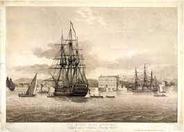
PHOTO SHOWS FORT AND HARBOUR BOMBAY 1850'S ;


LOWER PHOTO LUCKNOW CITY 1850'S


TRAINING THE INDIAN ARMY AT BOMBAY;FOR 'NATIVE INFANTRY REGIMENT'


'NAUTCH' GIRLS BOMBAY

PALKHI WALAS(PALANQUIN CARRIERS),WAITING AT BOMBAY HARBOUR

Grindlay explains that in 1811, the Bombay 'Green' was "an irregular area, surrounded by various public buildings and originally intended for the Garrison-Parade; but occupied during the dry season by vast piles of cotton bales, marine stores, and various bulky articles of merchandise."
![Bombay Photo Images[ Mumbai]: 09/01/2011 - 10/01/2011](https://ogimages.bl.uk/images/019/019XZZ000000400U00001000[SVC2].jpg)
BOMBAY DROMEDARY CORPS(BOMBAY CAMEL CORPS);
 Pin on Victorian

British Colonial Army ...
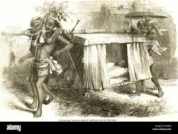
ALSO PICTURE OF A THUG(DACOIT) CHIEF
 Who were the “Thugs of Hindostan”?
THE HORSE RACE AT 'ABOO',BOMBAY

horse races at Aboo, in Bombay
PROVINCE LAUNCH OF SHIP 'MEANEE' WITH 80 GUNS ;AT BOMBAY

INDIA. Launch. Meanee, 80 guns, Mumbai ...

Flat racing on the Indian coast
![Bombay Photo Images[ Mumbai]: Adelphi Hotel BOMBAY 1850](data:image/jpeg;base64,/9j/4AAQSkZJRgABAQAAAQABAAD/2wCEAAkGBwoKCg0KCgoNDQ0NCA0HBwcNDRsIFQcWIB0iIiAdHx8kKCgsJCYlJx8fIjEhJSkrLi4uIyszODMsNygtLisBCgoKDg0OFQ8PFSsZFRkrKysrLSsrLSsrLSstLSstNzctNysrLS0tNy0rLS0rLTc3Ky0tKystLTctKy0tKy0rLf/AABEIAMYA/gMBIgACEQEDEQH/xAAcAAAABwEBAAAAAAAAAAAAAAAAAQIDBQYHBAj/xABREAABAgQCBQMOCwYDCQEBAAACAQMABBESEyEFBiIxQRQyUSNCUlRhcXSBkaGxssHRFRYkMzRTYnKCkpMHQ3PC4fCDoqMXJTVEY2SEs/HSVf/EABgBAQEBAQEAAAAAAAAAAAAAAAABAgME/8QAJREBAAIBBAEEAwEBAAAAAAAAAAECEQMSE1EzITFSgSIyQ0Fx/9oADAMBAAIRAxEAPwDI5eTfmnMJgL1559ZYm6qqu5ImZPVGZcIuUvIyI7AU6tf6KJHZqaFrbzvXE8LHkSvtjWdC6Pl3JZlwmgIiZHbJtD9keTW17Raaw9OnpV2xaWSyWqTY3FMv3j+5AOo+Nd/kjtHV2QG7qF33nC9ipGwBoyWH9w1+knuhwdHS481gOu/dp7o4zq6k/wCukRSP8Y2Or+juulBL/Fc9hQZauaO7W/1T98bKsmz9UH6ae6FjLM/Vh+VIb79yuafFi3xckO1v9U/fCV1bkPqP9UvfG2ow39WP5UhSNt9iP5Yb79p+HxYmmruju1v9U/fCV1b0d9R/qn743BAHsf8ALBoAw3X7M0+LDPi3IfUF+qXvhS6tSH1C/qn743JE+1Ati779mafFh/xWki/5Y/zn74P4pS3azv5z98bfbAshvv2fh8YYf8UZbtR38xwY6oS3akwX4ijbrIOyG+/afh8WIrqax1slMfmP3QE1Mb7RmP8APG3WQVkXffs/D4wxNNSh7RmPynA+JA9ozX5Tja8OBhw337Pw6hi/xHb/AP581+YoMdQx7RmC/EoRs2HAVuJvv2fj1DGv9n//AGUx+pBp+z0u0n/1bPbGyYcFhxd9+z8eoY7/ALOy7Uf/AFk98BP2cudqP/rh7axseHAw4b79pivUMfX9m5drPj/5LcIL9mjn1b4/efbP2RsWHBK3Dkv2Yr0xv/Zi99Yf6ge6El+zF/69R+9Q/QiRsatQg2YnLqdm2vTz9rBqfP6KDHcsNq+zGbLmKq0SqLn6YgxWN114YFyTsIaoT2AYdmiitYxPSMiUo6TRFXPEbcpdiDnT0LHp0dWb+k+7lqae31j2WTVJPkx+GF6oxsuryfIZf+D7VjGdT/mD8ML1RjZ9W/8Ah8v9wvSsebW8ku9fHCTRIXSOadfJtu1v51zYlbt1eKr3ETNe9CZidFlgXLidImRNjZsx92a0TJM04caIirRIQw6qQaJEfpGbERBpxzk+IAvzp4liyo9CKnFVRURU4IS8IdntJty9w4Zuk3bjgyKdQqqIiKqqiVWqUGty1TLOLgdiJARIXSOaZN7ZwWyMSuvMSQM8qIqqtUTfmiKuUMJks3mxK0nBEsEnzu7FMlWu5ESsEBC4IuDzSC8NlQWi9xc08cV3STIi4TZDe64Yg+bYqAga0Rtu7glSQjJVqtUyW6iWFJhlssJx8MUWbzuJAWmVVpwSq+eLtDohB0gsVvm3D1vXJx3eXhEdpMnJh0ZFsiALMfSk0JWKALkgIqZoRZ5puRPtJDAkrYCpDAzsqLgtC6FxGLAAO3nSqJluWiKtF4Iqwbk7LiLpE58wYg/sqe0qIqIlN5LVMkzzTphgyeRICiXWwpIOkTARSDRIUqQKRcBNICpCoTEwAiQLYUkCLgJtgrYUsCGAVsC2DgQwEqkFbCqQImFJUYbMYdhJrEmBVNdk+SB4T/KsY9rWnysPAx9Yo2XXX6IHhg+qsYzrf9LDwQfWKNaH7N6n6JHU5OoH4YXqjGy6tr/u1nrisc2Oz2lyjHNTfmD8ML1RjZNV/wDh7P4/WWM6vkkr44KLR8w9aUw5tGGBNA3SxlvfalUVVUloirxSuSURI6nWJgnQLYIGzGwCJQU1p84tEoqou4d3GqLSnYMLSLDCNLRhFMuuuOCQOW7HG21EUehEVUSu+qVTKqqrUlJEL5CTuKDBk/YLaAhumt1VqqqpCipmq02koiUiYpDbTIt3W3bRk+d281VfYlETuIkaQpfs7UcrCzZNCLgiDv798qGgfdFFzpuzp00XdHZSBBESEm8TgiTdjLDzj4ARIfLTqtFVUqq1VVNVWi1plkqqhnRbhMCLhCJuvCekD55UoqqiLuqqrSvAckrRIlidbErSIbtnYu6VVE8qoqJ3oOCoqW0MTLgO4o3Cb759TyqVERUqu8RRRqta1Xu1ck9Fi2LuMIGRzjr/ADcbJSWla5qVKIq9xN9KrJQcBEaN0IMqLPVbiaZdYvFvAvUlRVJERaISqi1XPetKJRETJyNrotYl4SYX2cxH3izqua1VEW5VXiaKlKRM0hINCN1o23Hef21Xj5k8kMgwutG60Ss27dtK8aLxSDpBrBCQkIkJCQkF4GO2hpwVFgBSBBw22625dhkJWnYdvSm9IBawIEEqQBwKQIKACwVICwFgOHSumpaQKVbmSJOVzg6OlTEVNL13ItM0quXj76x3Rm/7SNLTUvpSVEWgealGQ02zJON3i+4iklVyqqoiZU3Ktd8aHLOOONA440TRuMgZypb5VVRFVFpxRcvFGpjERKRJ2sEqwESBSMqSsJJYXSEHGZVWddU+SB4SPqlGNa3/AEoPBB9Yo2fXP6EHhg+qUYzrf9LDwQfWKLo/vLd/GkdTvmD8ML1RjY9VV/3ez/iessY7qZ8wfhheqMbDqqv+72vvuessY1fJJHihNJC0hAwuNQ5jgQIEUCkck2UxiCLbRENm2YuCGfQqrmiU4iirnwpn2RyNyDY39UIhceJ99gqdXVd9VRKqmSJTdRKLWKiEl0xJkbbzd5S3ZNZ2ZZqtVXNLKiKZ5Kq12lpP8pZutu5zxMbPSiVXycV4bt+UMtyZXYjz99uIAb2bBVarxXNaIlUpREoiJnXi0doxtwSLbtweQyRkWeGm9VSlKkqLlTcnSqqtVJJOS5N4mKFpAZ33WJQVoq58E4ruzhjSMxzmhdFq0Medmrs5Jvp7iruTxrwgz0WyRE4RGRdS65N4kpItKU3ru3bsocLR8uV1wkQuM4BhctDTPNeKrtLnvziDil3eTkLsyJYz9rErKjtrKhVERM137lJa7+mJZY5uQy+Jik3cez1YiU1yVVTOvdX0bodmGG3m8NwRMdnYLdktYghH3m3HTIm7GSZvxxG+9pVW5VolUvUUSq9bVUotY6ZzSxYQ4bDoE5iAB2oagKbyQUVa0qiJwqqIqpWJE2WyvubEr9h+4b0NKUoqLw7kKURLZIRtssstyp0d7uQHCTpE01KDsGQWPmTivKwKKiKl3Elqib61Wtd1ZBlsWxEWxERHmWwEAdnZHZ5mzzOGXRCkigUgUg0gQBQKQcCKgoKDWAiQGY/tOlRLSjLgjtlIBfdtpRCKiU4cVr0okaaa7UZHrHpRzSs7yltomRbAZVgCJDXIlWpCib1quSF5YtP7OtbpnTONLTrAC9LABnNN7CTSKqpVRXctUWqplmmSRu0TiEifVcVgQawVYw0SSw2UOLtQk4zIrWuf0QPCR9VYxnXD6W34IPrFGza4p8kDwxv1SjGtcPpYeCp6xRNH93S/jSOpvzB+El6oxr+qf/D2vvuessZBqb8w74SXqjGvapl8ha++56yxnV8klfFCeGFQkYWkahzCAsHAioECBAiwEuAJCTZc0gID6zJUouaQYAIiIiNoiFgAPWIm5IVAiqEEkHAiSgqQKQcFEUlYCJDE3OS8sN0w6Ife3+RM4i01lZu+jP2fX2pXv2qtUTv59zdVgTsCOKV0tKPWi2+NxfuHOol4kWir4o71SKCg4KBFAgQIEASxUNfZzWCWFktDttOtO/JXmeTFMuMEu5a1oiLuqSIiKiZrXK3wIsThHnCZdnybtecdG0yYeYw+SiCoqCqKqUStVoqEmXGH9V2dPcpem9AtGJtWyk1hWGjaGuQ7dUVKimaVpRFVeMTWtB6OHS8/1dgT5YTdjco5NLTrhXJURVWu5U8UWr9kCtYc8LREYpMtbeByVObuUlSqr3KrkqLxjtNsVy549V60e1MNyzTcy/jPCyPKpq1GUeLjRERERK7u5Tfvh+kKWExwdBQg4cpCSjMqrOt/0IfCW/QsYzrj9Lb8EH1ijatcvog+Et+hYxbXFPlYeDJ6ViaP7ul/GkNS06g74SXqpGu6qD8hD+M56YyPUr5h3wn+VI13VH6CP8Zz0xnV8klfFCeGFwhIXGocwgQcCkVAgQEgRQIOEOOC2NzhCA9mRWJ54jpjT0s2JEJEdvX/ADI/mX2ViqlIQ6622NzjgiPZkVkU7TOurMt85MtM/YuvI07iKlV8QxTZzXV6YcLkUo7MF9eY4KUTiirVV8g7o1FJlnMNPmtPMt3YLZOltbfzIn3Krn5or2lNaybG518GQLYAxIZVD/ES1r3s9+UZ1pCf0u43iTM2MuJGLFjA7WfGqqqp30VIea1aFshdmCxXXDLqzlTLKiZqtarn0xrZEe6ZlbJWcZmCxcUXevvbo8AcMqLn39/erSO5yYbHrv8AKvny9MZO5o9vnE0Jc3zqie2CZJ5u1JcphkCPDDCfIUrXuKka2G5rBq3zSL74F6FSHpV15n6O6YdgAleP5VqlfFGSN6Wm2xuGcmuu23C5T5FKtN8do6f0iyS3Twn9hxoaZ95E9MNhubBL6wTDezMNA6PZj1EvGmaL5olJfTsk5znCaL/rDYn5kqnnjFm9bNJN85ZRQLsasrurvuWmSpwh8dcJkedo8SHr/lK+0Yzxm5ujZi4NzZCQ9mJXp5Ug6RiDeubbZXcmmgLs27Q86EixMSP7Ria2eUq6PYPSzjy+NUSvniccruhq8JWIXVzWH4TaFzkjoCWxyoerNmqb0rkqL3x474m1SM4Vj2vbmHpua++x/wCsd8WT9lJdTnx/7xo/KK+7zRWNfQItPzAiO11L/wBYxYv2VIQu6QEuuZ0e+B8DrieykdJ/VmPdoMJgEQjzit+9AWOTZJLDZLCyhCpGZEBrenyL/wAkPQsYtrl9LDwZPSsbVrgl0l/5Ie2MV1u+lt+Bj6xRNH929TxfaR1KTqDvhP8AKkarqa6WATRCVt5GB8ATLJV6a1jKdTF6g74T/KkadqqEuLYO4gA7ebB7KXPDRFpXevSn9Yzq+WVr4oW4YXDEs+282LrZXAW3f3OnOHgK4bh2h7MY1DmODiC0/rZozRXU5h+57rJJvbM/En/3PdFK0h+0DSc3aElLDLC68MqyZuIBPEq0REyVVzVMqCvljcVmUy0qcnpeWG55wR+xz18iZ+OKjprXyXYuEXAZ+9R5w+8KelLozrSL0y426/NzjrtkyMi9Kt/IkuVK761VKKnTn3M4LRkq3LzM23MNC0DYFyI8PM1quaZLXKnBY6RSIZylJ3XCbmSI2JYi/wC9mSsQO9XcncoMcM2mk3HQbnZx0CdOwGWBwbKoq5rWqJRN13ijpZ0c9MSTUo4wZGJuv49qblJFTNc1Wiom7ucImXpdxwrnnGhtBsLxq8p0RK1TNUWqb6cI16QYVWVkGZfTJaPwAMAnG2HpoqmWYKVVWuWaRNz8mIzLOGQ2Ab94C4ppzkRMk4pVIlm2mxudcI3jI8fqhWIGaLkvRXpTjDzbmGJE22Abbh9mWaoua7lz7nCJNlwhtKyfwmWy2+IcpvAyEZW9aVSirX+/NJuS72LbMYQANvJT5ivqqCqpmtFWuWXRAcccxBHEIR6neA9RQ8kVckom+GRYts6n++7HLhAwrukm5dxouTPiR9TsArd1UrDKskOj2hFsSeCZEwYbb5iIi0WqJmlVXLuQ5LsN9iJbA82hrvTohx6UK7ZaLrdi3MN2VI0iJk5EsA2nmjEdp/HtzrklE3Z5J547ZKWFzShNuNiQGBheRYImtq0Xdlmvmh4WStEsMh53Ww6puWiIunzOZiLwyi5MI6V0WTz5S2HdZdftIG6iLRaJXJO/DWltHudRYERvftBgOBqq0Sq8M1SJIJhy63FIvvFf6awknXNkis2TvA8EagvCi0qkMphGaV0a5KOuti2W1YDOytapmtFTLeqeWOmRknGyLEE7MFi+4VBANURVRehd/lh03nHPnNsh5l3i6KdCeSHm5ibcuLFERvA39+3RUp6IphoOgp+YktBYkrKFNGU+6GALliglFVVqqLWlN0T+rU/NzLB8rkilSae5KAE5jE+iIma5JRa9FYh9WmplzQxYbgm8M4+d7oqaHUVSlBzrnlSO/Q2lsOUB2dIcWZZ+EcCWYcPkoqiVRa1WqLVKrTcuWSxxlpRtcgxNYnRbcJoywgB8d4LhjmkWTU3QZSk6bvLZp26WcM2HHdl81KikooiVWib1rvis69Hdpaacl7SMXmmAeFxQsq2KJRUyrXu5dMOai6SZlNKPcrnjO6QdsB10nluqi2JVaVVEUkQUJVu39Opidqf6uetTulRcabkCYFogvfxK3XIqUpnu3buKR36vuTZSLRTrgHMXuXm2NiZEqIndWiJnlFf1o0qzMSxuy887KOyxj1C1l9H6mKKqqqkiIHFbkQa7W9ItEjKckYRjFN6y7qzttx1JVztQU48ESOc+kNH4NUhKQFWMKgtcRHkP+MHtjEdck+Wh4GPrFG263J8hL+M36YxLXH6W34IPrFE0vI1qeL7SGpnzDvhP8qQ5p6eclZxpxkdsAB9h4hQ7FWqJRPEvmhOpXzDvhP8AKkL1ikOUO4g33dQlTARU7LlJUoiIqkuya0TgiePX9pX+MBL6RfecK1x9JU7ZWatJbARBzUxRKIud1KKg13qiZ2VnWudYkRZtEgaufYfeK906IqrkOWSKipRd6olc6pVZSWLR1jrwk1+8YO1DWdBbkuVKKqKKElFGqpVKZ5xBzk6TjgOkR3EZHzbL1qtFrVarmlV3704JHo2xLhnDSNN6wS83IgQi7ijZjzuIVMQ6CqJVK0VURaClOPGqx7ehR2ycfz5WGm9m58gOiZVSiZUTIq8FXfFNYnJ15/FvbuctlQVxoTRtbURFFFRVFchzGmdOCZTujdNYZIJPiouWsTLGbgsCipagItaIiJTeq9Nd8NuPYicp/ksuN+y6V5ib1xclQ16VEcl3ImfCkONFaQiy2AbG2DbabfDjVeiIY52fIicJwrBnCO/DGptKq2qtBWtUUc8veua0wzhMtlcRCzY8Aip3lVc81SuSold8ZxLWUw88LNpTLhAF+xiV21y3Jx8XDuQBnpcnMASIjFkZrZbXbRVVEzVOlI4DF6a0e024wbIMHec66PJRBN6rUkpSnGqVpHXojR7U2RPyk9JvWshKna+RqFSVaKKIlM0yLjn0QMpVAEsFsv39wAYkgWIiIq5Lmq5UondWEzJ4dw2j+8ANlTXLimdOnfDoaHnScAnJli1r6KDY3qCLRFWqpXdWHR0K4Nrj06TpCd9jY91FVc7UStFTxxnMK4Je4nRuuEez5iGuHXfuXOkR+rpOOMMk5diky0b9xXlmKVVUXNKwue0tJaKdAHpHSJuu2v8AKXBBlOaqUuQiRaJVcqwS6zXVfa0USu4ISrNz5UeFEXf1NKLu3Ku9d3HXqmUQ60TbZE4JDaDd92xZtJvWEyui5YZIW3BMJg8QDw+sRFFFRFWuaIqLu79ImNOPT8uItTcilroXsvtTaaQA7VFVqiiOVF6YqizpPfSGya2wYxrcgpRV5yrTNa7s0VeKIi6j1ZlKEcuy4MzhkZk98iuuNX99chqqomeW5FRUqlEqoZ6WeIXCddEiBtiy6xDJaoi70StelKeyHKUmWxF+WIXXnbmJo2Sx0YRVVKW0og0yJVVUSqpRITNK8ThEN8w7eLBvyzmNkqLVMk6EXJKUWvdRbhMu6eccZ2cU7rBsMRvQMkVUzVct/FfTCXcTqO1848IHcKHv7+7fDMqUpaLb0lPlMbIGYkAZrnShBVEz6Y7Zp+UlyGWm5TSeNLTl5gWG9YqUVErWlO4ntgpnTLTko4TV1wjtgeGh9PHju3R1MNODbcVpHLNv7Ipt7Sp7IROaW0VMltS06BXkd5MNGmaJ9tK7o49KaUl5i0pdsWtu9/ZRnitKKiqu7vbqZ74DU9TNIyjOjSamZloSKcdvYcJK0VETmpw38Ijp1nQjLjRSmkAAG7TCSeYdmhYJEVEUSRKjktM7skSltM87kdNuS4iNt4XkZhlXdRM+/TL/AOxLaP0qzMNXODt9eDQqaAilROCrvVEr3YztXMJSbcHDebZIbBM7wabOyqVWqJalUpRd3R0pFd1Ok5uZ0uzLDYB4zr53CU02yKiqLlVFVKURNpF3Z1iyYg2tEI9SILL8QgUFVaJREyou+tc8t+SpG8rKQ0oL8o6EuQyxgc0VN1a5qtUXd0KsWCWmaO1Wk2CR11tp4xPHbCyxtg1VVUkFVJblVVzIiVEyRUzrMukLYk44QgI88yKxA76rGeyesek59sxc0tLyWGYsdTls30VKoqEVc6b0REpl0xwT+iZdwceb0y/MWneZuMuPYCLvVFVCp5o5zXPuuV5d1n0M3ztIMF/DJXvJRFrEFpP9oMuNw6OlDmC+vc+Sh30TeveVBinm3ojEJtmbIyINiaJpw9pVXJUpXJE35pVUpXNE5SmmW3LSvIW9swbbsI+hFJVSmdM0DivcWLsgyln9OaTn3PlLo2dqtN2AC8F4qvjVYpeuP0tvwQfWKLw1OST0sWG0QTAnZZiC8ltd++vSlaUika4fTG/BB9ZYxp+X6dL+L7SGpnzDvhP8qQ/rFP2lyTaFHAAzeF1QyUlRailEXJFTaXjw3wzqX8w74T/KkPa0NMiTJEAXPgcqc68R2yVKKijZxWpdaSrlRN8Z/tK/xhW5gXnBuvMx683nO4lEz40tXdupTKOxuVecdNqXkX5ghuO/BV8gAapXhSiImXuor8voptlwTmWzdaNkH5WaY2Fmm+kb0RUyRUzRF8UWrVTTGjAIweGwh0e+jzxUoZEbhIiIlVJExlTdwToj0Tb09HnwpLmknHHMJ4TeQHj2MRQR6qUzRUpw30qtV7kOM6NJwRIpmVD7BX7k7qJTzru3xMaxFyvSzxM3GHLOewKvJkiCi1RMskrHLq/peU0RylidkeUvDPyz7DmwdigVVqS1p1q0SqLnXu3Pp6H/AF26JkZ0idGQnQaATbx5oXAYEBVURKESJata5VqtF30ixlqnpW+dxNLzVrGHZ8rPmKq70TJVUct2+IbUuYlinZ7TMwwVnLGtIyobM0YKhqq0Ggoq5qNRpbVcovyaZZmNKTciyJEEzIN4GkB227kRUoqouVEWufFFSMWmYlqIR2itU25UmicdxSm5Cw8X5UhklxoSiYqi0SiUVOmkSKaEl3nZ3REwLRByBqeYtZRnAuI0RUtQUyolM61TvR1acJyU0eLrJNOuyejXA6o5lmCii76rnRab1plVclY1W0q5pF0tJOSxMi7oqWDGLYF9birRejetKrRFTpjGZ91RujtR9EPDMdTPqEyUrfiHWqKlV52fFPHFY09oGUb0ec3IY4GLxBYTi0ojwBXnLXIovMrOOSGlCkXLTanjd0jy0XMpJaKtqqq5bt/dyTopesAC3rATExN40o5LOT0rhktskilcjeyq0WoImVFzTckarM5JR37NtHN6T0kQzGKbTcs7fiFfYSpkqZZKmdN8X5llkdYC0VhuYXwJ8Ih1VKVQ0RdmlUXNdqvcpllWtTGm2ZuSJlg2eouMTT1rjPKnbSWpotEomzRUyqqpFmmjGX1mPSDhCMuGrbrD81z0BbxWmS78t3dhacykexGv8vyaSDBalwl2JYwBi7kXJcxRKLuRM0SmXGKl8XsVg3WXGmhYmJqV2DWZ2m139zJarxRcki6623aX0VdISwzovsngSrlzIzVCFaKqKKpzVXnJuim6SmZiS0gciLgCyUy5NTUqwRBtOKqkikWaKqIlaLTPKnBX2JQWqurrk+5yYZ11maKZYxmdq0GVFDUlVKZoqoqVWhKPjSUldHjJaZHQjZCTIm38qctvNVG9URFRapklR+yi1yhvRE7NyD5OSTRk0xM7Zi2jyAmaIhKm+qVRM0qq5Zw1Mz7k3pItIC0LQu/JQfdFcSSdECSiIi1RVp0Lkixuc5TCy6KMpibNotHmDLYFgTW1YFCTOipSqrXNF8vBnX05ducetdATvx3wF1QWuwlCREWqUJSoqpwXupVB1kw3SdFw3XSBwDmiJAvVaJVKJklETLudyG5vSvwm+87ObLroc+5Gc0pkmyWdKIiZVpSvGEV9cmRNMSzmjXXXp0Amsb5FJCJGtib1VUWiIqqu9F5qZpnEcyy2TeK5j3Y2B8yuHcqKttyVqtKFRURadMSUvPcnb6m2DJXtg+8I8qJ9KLRM1RETJMxzqm9YmdPaRb+C9GynNEmT0rOsNlz6kigtyJvWi1WnGNZRSHbR2RK63r+Z3qJTx+OO/Q0s844DbYiBOPOAE0W2tEGqonQuWSjRaqmaZRNzMtJXBKTDlo2DznFmlYRc1tVELNV6abk3VWFTfwUyRfBmkiwi6yZZcZUCRESqK2KZVRC3ItU41hkwa0e+2Tp6Pem9lgy5KYtqF6JWq5IiqtV3qtVpvhBTEgzMtOTD5ui09ecq3eCmqZolSRaZrVe90rHIWkRbK0tIS5GN22Us49vROkU7i+LNFjnZwycJ/wCFNrs8EjV9aJVdyUz80MGUyxrK5LucpkMUGiN0zYccV68lQcl3IqIqKqZVS9aLuhWmNc9LzAk28+LQH/yrbaW20RUoWarWvT7aRChKuEJPTZ2j8+w3LKa9K0JSTPuw+zM6KFsG2xmHXb7DNxlAE0VcktvLd5d8MQZcUnOEyJlcRC7awdw8Oiq7u/HZoeZkGSdKbF8hcZsBlkQpVa1VaoqZcFoipWOObRu4xEhC4B2Bb59FRfEuW+ClGGy/eFsgWwI3rREVVpmkJISmiBZxRwb7sEzP0J3UyXPu0iK1vX5WHgg+sUSujiZcm2iHZKxzYFtAE9nNclWi5KsRetyfKw8DH1ijjTy/TrfxfaR1M+Yd8JL1UiySs3MNzrPJhEjG587nsFGBRFVVXZJURUqKqiV3Ii5qi1rU35g/DC9VIlplzDfFwZuTZIWbw5SKVrVc0VUyTx9Mcb+WXWvihy6XfbmHSmREAadxTNjDU+8iEqouaqi0REpVfGNTdOlJOk0MsDpO2SrLGJg3kqoiZoJb1om7j4o552c5Q60xc0doEbxyF00ppVK5Ii0374kGgl5J3ElJedB3Z25txmVRtUVFQkFBM0XJNwovej0R7YcJ91sm9bW5aZOUmORlhHZe3iPWIvBUQFVFTj05LuVIoemHpKafl33sJnYCVetdMCZBbUVSRKJvVxdlelFrkidzMsLhETxYrrky4/NTotCavmua5GqL+JRVV3rD8jqsy851aWN0NowNx8ZWxaqqrQUGqVXp70IxBOZSehFlpSZZlmHJYpQWZptkxIjNgkVtVzLNUVaknDNadEWxtxshtbmxP/EQ/bWKw1qXIDtchC28tgnTe8VVqkSMpoGSbK4dGyv4mxeXyqkYnErGUqcu44JNkV4FsPBzxNOhUrmnchxpgmW8JlsAa2eoNt2CFEolERckpwSAwTbfzbAD1my2ge6Oxp37Vv3oyrkZl8NvDFpgRHmALOXe3x0sm43sjYI9gI/1h5XPs/lhKOCXXff2Vp3E/vogEOzTlu0RW/dT3xzuHLzDeG8TToFz2SETTuVRVjpRR2iEbh+z09z++MMIRERXSxc/YusofeVFVd3TSEA2GBbbEZe0AHmMs0ZEO8iLRI55zV2Qm3eUvMCTxf8ANDUCy8ax1tOkX7r7F+InsSHFL+xJT9kMyIH4lSVxkLs0JO/P4b6M3pWtMk3VzgpHVCWknSflJnSIGQWGYvId6VRaZj0pE9jfa/yrDZKyRWk6d32XiBPTSLulMQrq/s/0JtE4w+Vx3nc8u9c+Cw61qTq+3zZZ27s8R4+7wXLxROpLt9k+P+KXvgibb5uKX4iQ/OqRd09mIVwNWpAiNgdGhgiY3zRPkGPStEzWqLRVX37o4ZzVFvZFkWhMjI+S4pzQBsoiKlCFUVLclrnRcotyMj1r5l923h0USGDkyxMTlM0RDcABalvdyti7pMKKupM2LolaNo3X4bZnfWvZuFSncpvzh53Vab5IDGA+R7N58N9ebdRIuSh9l0v4g2eOGTxrdmWAv4hIHjyr6Iu6Uwz8NUJ1l/Ew3bStCwWbOhK3IUKckcErpnlgDshYTi0Nenn9zd3YuZkRfONND2dpX/ywYSjJbWG19/DT0xrdJtZ7MMtvXOMuGOJ1AGCbzNN2W0vTujqGRmG5IJQWCIxO8JrCXsq0VK+LfFvOWbu6mTQ9na2nvhJjh858vyoENxtVAJV4fnNEtO9meGYLWq/bWie6OyWaLat0E0JFsX4qyticapTNPJE2swJF86ReT3Q6s02I3XF68SbLEIlqRFkScckgadHmG1zaeNaxTNcfpoeBj6xRen5nEL7MUTXBflo+CD6xRz0vL9Nanj+0lqf8w74SXqjFna0BKzpY8xcRD1Cwabkz416Vitamp1A/DC9UYusivUiG4Offtd5OEcdWZjVnDrSM6UHpfVrRDY24QdntU2OnhSHh0fowdlthj7GyJ3p4lhrHZbtxHWvtgI5+T+kK5UyRbN338NQ8606O7uixaWJh2AUpzW2wt7C1KedIf+E22x52z2d3pziKdSXcHaYv2P3godnTSqLABuXG3BlmBL7LaexE3RvKYd56Ub+tEvxJ7VhHK+uxB81T7vGGcQrRtEPv5Bu4JmsIGct2XJkPuZexIZTDsxXPtF5Q9CR0NgRdcX9798cTbxOc0rvu1BfZDyOkXNbdIuzy9qwyYSDSEP8Af91h6n2v78UcAoRDtNl+IrPRlDo7PWj+a+xfLEyYdVl3OIoJXG7eb/JfDQgRDtXD90YK0tn/APWUMmHSiiI/3SsGr3W2kX3RU4Yr2Rf5r4QOJbbsl2FtfdDJh1k5s/Z88MPW2/N3fer7YTYJWkRERX7G0tfKlKpCXWxcG3Z59/dhkwMnB5pN3fet9qwSviJD1v4U2E8SQyTY83CaP+IVnmpvg1AR2R2PsCKU8sXJgw/OTN1zYkY/eTYT8q18cLZmJhy64RAftD6CqlfJBI72Nt32i9C//YZfcK7nD5/IlP7pFyYOljXdZb2eJz/INY4ZkCIruUiBc/ZJT7m5VovfpHRdcPY/33VjhcMfrOv7JfQlIsSYc01KkRCRTb4/wxH00ySOZRl2xtx5h4uvxSWa8iUXzRJths7Lf47VNfPD0vLDbc5+P3VjW5MIgpjrW2nbefeQlTzoiRFzTrnOw7B/DtxaX2R2eqfliKekW+xLa6/IPFksItBhAtT2HtFYO31xF7ESHnpl5y20i/Ln5463WRb5ol5/TEcrdzl21s9YMazBg8wZXDcXoir63fTR8DD1iiyoFrodj2HiWKzrd9NHwQPWKMaXk+l1PH9pPU4uoGP/AHhecU90WyXW7nOkI9hdZf5lWM60FpfkTpC4NWnbcY+LNK5onHfui3Naa0YQ3NzjSD2B1ZXyLn445a+nbfMxDppXrNIiZWMVb+sAfxKfj3w08AkWy4NvP5omnkWI1JgS2hISHsxK9PKkOXx590w7bId4tNkNpOkP3XFZ8yQQC2P7277G0fjqqxxI5Bq5F32TjhIibPWuAN3M6nf5K9+HQeZEfn/9PP0REC5AJzmw32OOE6E7L9c4RW9/0URIdXSct9Yf5VivYkFiRN9jjhY/haX7Ivywr4YZ+0P4YrilCROG+xx1WL4bZ7I4C6Zb5tp29fFdVRu2utglcGLvk46rCOlZfsT/ACp74V8Ms9idvi98VzGtgYkN9l44WNvTLIldhld91NvzwZacl7fmz/KnviuI7swROjE32OOqx/DbNtotH+KnmzhHw031zZW+I8vL/dYr4uQZuxd9jjqmy0myX7s/w0hlJ5vrRP7nCIjF+1AJ2G+xx1SRzjZDtNj6/wDfijlZLDLZEbdnY9uSd6Oa/nQtHBi8ljjqlGp9sec3/mSOhNKS/wBWf5kiEvGEo5E32OOqaf0i2W0LRfmjmWYbL93Eeh7UGjow32OOromCFwdm78X9I4ylh64h/L7VhSvD2UIdmP5YsXubKm+SiJYhOkVvMDDQE6N9e/FM1s+mJ4MHpKLmbuzFM1q+mp4KHpWPRoTM29XHWiIr6IdUhNsCBHueFIaJ0y9o/EERFwC2ybXZovTWJBNbHe1x/UX3QUCOWpp1m3rDrXUtFfc4mtr3awfqL7oJNbHu1g/UX3QcCM8VOmuS3YfG5xd0oCf4i+6CTW17tYP1F90CBDip0cluw+Nr3awfqL7oL42vdrB+ovugQIcVOjkt2JdbXu1g/UX3QSa2PdrB+ovugQIcVOjkt2P42PdrB+ovugl1se7WD9RfdAgQ4qdHJbsPjU72sH6i+6E/Gx3tcf1F90CBDip0cluyvjY92sH6i+6CTW13tcc/+ovDxQIEOKnRyW7Gmtj3awfqL7oL41vdrB+ovugQIcVOjkt2Hxre7WD9RfdAHWt7tYP1F90CBDjp0cluxrrY92sH6i+6B8bD7VH9ZfdBQIcVOjkt2Wmtj3aw/rL7oT8bz7VT9X+kFAhx06OS3Y11vPtVP1f6QB1uPtVP1f6QIEOKnRyW7Bdbi7UT9X+kGutpdqJ43bvZAgROKnS8lu3M/rVM9a00Pfq57UiNdmXJlxXXSucJLic3V4bvFAgR206Vj2hx1L2n3l//2Q==)
Adelphi Hotel BOMBAY 1850

byculla hotel and


Morning view from Calliann[KALYAN] near Bombay


The Horniman Circle Gardens in Mumbai, formerly the Elphinstone Circle, were named in his honour.
The Reversing Station, Campoolee, Bombay
 BOMBAY BROKERS AND TRADERS ;DOING SECRET BARGAINING UNDER TOWEL ,BY HAND TOUCH(READ THE NEWS IN SMALL PRINT)
 150-year-old cloth merchants' code ...
COTTON GREEN MARKET
150-year-old cloth merchants' code ...
COTTON GREEN MARKET

Bombay (Mumbai) Cotton Market - 1869 ...

Pic. DPA-JSA-151424 | agefotostock
'NAUTCH' GIRLS BOMBAY
PALKHI WALAS(PALANQUIN CARRIERS),WAITING AT BOMBAY HARBOUR
Grindlay explains that in 1811, the Bombay 'Green' was "an irregular area, surrounded by various public buildings and originally intended for the Garrison-Parade; but occupied during the dry season by vast piles of cotton bales, marine stores, and various bulky articles of merchandise."
Bombay Photo Images[ Mumbai]: 09/01/2011 - 10/01/2011
Images may be s
BOMBAY DROMEDARY CORPS(BOMBAY CAMEL CORPS);
%26mweb_unauth_id%3D%7B%7Bdefault.session%7D%7D%26amp_url%3Dhttps%253A%252F%252Fwww.pinterest.de%252Famp%252Fpin%252F176133035407509866%252F&tbnid=sFuo2gNhq0WxpM&vet=12ahUKEwjK9OqJuJbtAhUQVCsKHTNIAvUQMygFegQIARAy..i&docid=mFp684yP1Zq6vM&w=365&h=616&itg=1&q=BOMBAY%20DROMEDARY%20CORPS(BOMBAY%20CAMEL%20CORPS)&client=ubuntu&ved=2ahUKEwjK9OqJuJbtAhUQVCsKHTNIAvUQMygFegQIARAy)
pinterest.de
INDIA Barras Camel Corps raised in ...
British Colonial Army ...
ALSO PICTURE OF A THUG(DACOIT) CHIEF
jagranjosh.com
THE HORSE RACE AT 'ABOO',BOMBAY
horse races at Aboo, in Bombay
PROVINCE LAUNCH OF SHIP 'MEANEE' WITH 80 GUNS ;AT BOMBAY
INDIA. Launch. Meanee, 80 guns, Mumbai ...
amazon.com
BOMBAY RACES Flat racing on the Indian coast
lot-art.com
HOTEL ADELPHI BOMBAY 19TH CENTURY
Adelphi Hotel BOMBAY 1850
oldphotosbombay.blogspot.com
byculla hotel and
More photos of Bombay
Approach of the Monsoon, Bombay Harbour[VIEW FROM
MALABAR HILL OF BOMBAY]
View of Bombay Harbour
Panoramic view of Bombay taken from Chinchpoogly hill, Parel, looking towards Cumballa hill and Warli
View of Bombay, from Malabar Hills, with the Island of Caranjah and part of the Indian Continent in the Distance
The Stranger's Lines, Esplanade, showing part of the old ramparts of the Fort, Bombay
and guns
Bullock-drawn roller, Bombay
View of Bombay from colaba island in 1773--Artist: Forbes, James Medium: Engraving Date: 1813-- THE FORT WALLS AND THE ST THOMAS CATHEDRAL CAN BE SEEN
'Bombay Esplanade from our(soldier's) Tents. March 1870'.[MALABAR HILL WITH JUST A FEW BUNGALOWS AND GOVERNOR'S BUNGALOW can be seen ]
Figure 1. The Esplanade, Bombay 1857.
Please click on this image and later ones for larger images.

Please click on this image and later ones for larger images.
Morning view from Calliann[KALYAN] near Bombay

Khandalla, Bombay
View of Bombay Harbour. January 1870
View of Bombay Green[ now known as Horniman circle]
The Horniman Circle Gardens in Mumbai, formerly the Elphinstone Circle, were named in his honour.


The Reversing Station, Campoolee, Bombay
 |
 | |||||||||||||||||||||||||||||||||||||||||||||||||||||||||||||||||||||||||||||||||||||||||||||||||||||||||||||||||||||
Matheran.--Photographer: Unknown Medium: Photographic print Date: 1855  'A Sketch in the suburbs of the City of Poonah. September 1871'.--Artist: Lester, John Frederick (1825-1915) Medium: Watercolour Date: 1871  Callian,[KALYAN] Northern Concan--Lithographer: Ackermann, Rudolph (1764-1834) Medium: Lithograph Date: 1820  The
view shows the islands of Bombay, part of the village of Mazagaon, and
the Mahratta mountains in the background. The top of Belvidere House and
Cross Island are on the left; to the right is Fort George. Ships are
pictured at anchor in the harbour  This
is plate 8 from James Wales' 'Bombay Views'. The series was painted for
Sir Charles Malet (1752-1815), the British Resident of Poona, who Wales
met in Bombay in 1791. . Across the water is Chaul and the Kanheri.'  Fortress on a hill.--Artist: Johnson, John (c.1769-1846) Medium: Watercolour Date: 1795  Bhore Ghauts.--Photographer: Unknown Medium: Photographic print Date: 1855[before railways were built]A photograph of a view of the Bhore Ghauts near Bombay from the 'Vibart Collection of Views in South India' taken by by an unknown photographer about 1855. The reversing station on the Bhore Ghat Incline under construction, with the hill known as the Duke's Nose in the distance. The idea of a railway to connect Bombay with Thane, Kalyan and with the Thal and Bhore Ghat inclines first occurred to Mr. George Clark, the Chief Engineer of the Bombay Government, during a visit to Bhandup in 1843. But it was not until 1856 that Bhore Ghat, 15.75 miles in length was begun under the direction of engineer William Frederick Faviell. The work was continued by Solomon Tredwell after Faviell's death in 1859. About 42,000 workers (peak of 1861) including many tribals, 32 different classes of artisans & labourers (10,822 drillers/miners, 2659 masons, buttiwalas to load & fire blasts, storekeepers, timekeepers, interpreters, filemen, platelayers, trumpeters for mustering people, thatchers, harness makers etc worked here. Coolies travelled on an average of 15-20 miles a day and carried an estimated 6,296,061 cubic yards of earthwork on heads. 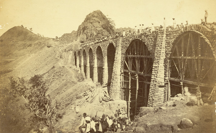 No higher resolution available. Railway_bridge_bhor_ghaut_incline1855.jpg (712 × 438 pixels, file size: 131 KB, MIME type: image/jpeg) Esplanade and Bandstand, Bombay.--Photographer: Unknown Medium: Photographic print Date: 1855 photograph
of the Esplanade and Bandstand, Bombay from the 'Vibart Collection of
Views in South India' taken by an unknown photographer about 1855. After
the fall of the Portuguese fort of Bassein in 1739, an Esplanade and
parade ground was cleared from the walls of the Bombay fort almost upto
present day Crawford Market. People sometimes drove around the esplanade
in the evenings as a form of relaxation or simply sat around relaxing.
In the early part of the 20th century, tents for showing films were
pitched here.-  Basseen(VASAI) Fort'. Captain James Barton's 12 Views of Hill Forts in the Western Ghats near Bombay, London, c.1820. Pl. 6. Ceremony of admitting water to Victoria Dock by Lady Reay [Victoria Dock construction, Bombay].---Photographer: Taurines, E. Medium: Photographic print Date: 1888On
21 February 1888, after work was completed on Victoria Dock, water was
allowed for the first time through the sluices communicating with the
Prince’s Dock. Lady Reay, in the presence of the Governor of Bombay
Richard Temple, the Trustees of the Bombay Port and a few others opened
the first sluice, and the dock was filled with water by the end of that
month. The intention of the Trustees was to formally open the dock with
some ceremony early in April when the direct entrance from the sea would
be available, but the demand for dock accommodation became so urgent
that in the early part of March of the same year, the first steamer, the
St. Regulus, was accordingly admitted through the communications
passage. Entrance via the sea-gates was made available on 3 April..  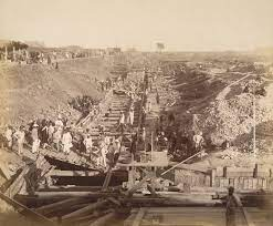  Church Gate Street of bombay fort , --(and Times of India office).Photographer: Unknown Medium: Photographic print Date: 1860 This
view of Churchgate Street, now known as Vir Nariman Road, in the Fort
area of Bombay was taken in the 1860s to form part of an album entitled
'Photographs of India and Overland Route'. Churchgate Street runs from
Horniman Circle at the east end to what was originally named Marine
Drive at the edge of the Back Bay. Churchgate Station, the old General
Post Office (now the Telegraph Office) and the Cathedral Church of St
Thomas, the oldest still-functioning structure in the city, are all
located along its length. However, Churchgate Station and the Post
Office were later additions to the street and would not have been in
existence at the time of this photograph. The Mazagaom Bunder, with a vessel stranded [Bombay].--Photographer: Scott, Charles Medium: Photographic print Date: 1850hotograph
of Mazagaon Bunder, Bombay from 'Views in the island of Bombay' by
Charles Scott,1850s. In the 1770s since Bombay began to trade in cotton
with China and exports of other goods from Bombay increased, the British
decided to build a new dock at Mazagaon, which lay east of the main
island of Bombay. The area developed due to the growth of trade and
subsequent economic prosperity of the town. Land reclamation projects in
the 19th century joint the islands making Mazagaon landlocked and
losing its prosperity to neighbouring areas.  View of Bombay', after the painting by Lambert & Scott. Mezzotint by Elisha Kirkall, c.1735. Printed for T. & J. Bowles. Presented by Sir George Birdwood. Etcher: Kirkall, Elisha (c.1682-1742) Medium: Mezzotint Date: 1735 Mezzotint with etching of a view of Bombay by Elisha Kirkall dated c.1735 after the painting by George Lambert (1710-65) and Samuel Scott (1701/2-72). Inscribed on the front is: 'To the Honourable the Court of Directors of the United-Company of Merchants of England trading to the East-Indies this view of Bombay done after the Painting in the Court Room of the Company house in Leaden Hall Street is most humbly Dedicated by their Honours most obliged and most devoted Servant John Bowles.' The area of Bombay was composed of seven islands separated by a marshy swamp and inhabited by Koli fisherman. Its deep natural harbour led the Portuguese settlers of the 16th century to name the settlement Bom Bahia 'the Good Bay'. The British Crown acquired the islands as part of the marriage dowry of Catherine of Braganza when she married Charles II in 1661. Bombay was then presented to the East India Company in 1668. The East India Company’s navy was founded at the beginning of the 18th century to protect shipping against pirates and the maritime Mahratta states. Ships were built both locally and in Britain and eventually the fleet was sufficiently powerful to be able to go into action anywhere between the Red Sea and China. The second governor of Bombay, Gerald Aungier offered inducements for skilled workers and traders to settle here and the town quickly developed into a thriving trading port and commercial centre Khandalla on the Bhore Ghaut, Bombay.--Photographer: Unknown Medium: Photographic print Date: 1860 his print was taken by an unknown photographer in the 1860s. It shows a view of Khandala, a small hill station in the state of Maharashtra, Bombay Harbor with guns from Apollo Bunder.--Photographer: Unknown Medium: Photographic print Date: 1855 A photograph of a view of Bombay Harbour from Appolo Bundar from the 'Vibart Collection of Views in South India' taken by an unknown photographer about 1855.The East India Company’s navy was founded at the beginning of the 18th Century to protect shipping against pirates and the maritime Mahratta states. Ships were built in Britain and locally and eventually the fleet was sufficiently powerful to be able to go into action anywhere between the Red Sea and China. Angria's Colaba.-Photographer: Unknown Medium: Photographic print Date: 1855A
photograph of the Colaba Fort in Bombay from the 'Vibart Collection of
Views in South India' taken by an unknown photographer about 1855.
Colaba Fort in what is the Konkan region is nine hundred feet long and
three hundred and fifty feet wide and was built by Shivaji Maharaj in
1680. Of the two 'dwars' or gates, the Mahadarwaja to the east is
decorated with tigers, elephants, and peacocks. At high tide the Fort is
inaccessible, while at low tide one can walk across to it. 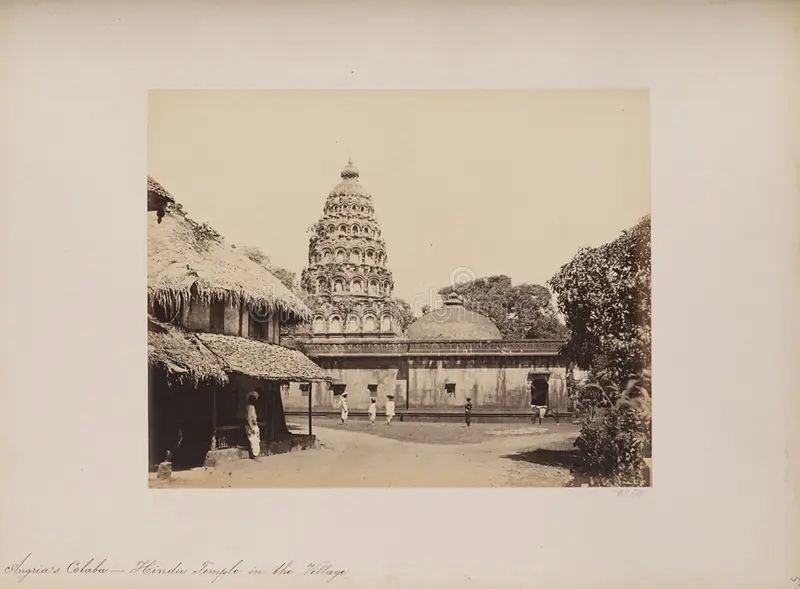 Marine Battalion, Esplanade.-BOMBAY-Artist: Gonsalves, Jose M. (fl. 1826-c.1842) Medium: Lithograph Date: 1826  Lithograph of the Marine Battalion at the Esplanade by Jose M. Gonsalves (fl. 1826-c.1842). Plate 4 from his 'Lithographic Views of Bombay' published in Bombay in 1826. Gonsalves, thought to be of Goan origin, was one of the first artists to practice lithography in Bombay and specialised in topographical views of the city. In 1772, the English feared an attack on Bombay by the French and cleared a semi-circular area of land around the fort to provide a clear line of fire. This area was known as the Esplanade. In the southern section of this area, there was a parade ground known as Marine Lines. This view shows a battalion soldiers on parade with military bungalows in the background. BOMBAY-Back Bay in 1861.-Photographer: Johnson, William Medium: Photographic print Date: 1861 Photograph taken by William Johnson in 1861, of Back Bay in Bombay (Mumbai), Maharashtra, from an album of 40 albumen prints taken in the 1860s. The busy port and industrial hub of Bombay is the capital of Maharashtra. During British rule, it was the administrative capital of the Bombay Presidency. Extending over a peninsula into the Arabian Sea on the west coast of India, Bombay prospered with maritime trade and became the chief commercial centre of the Arabian Sea. Originally a collection of fishing villages of the Koli community built on seven islands, Bombay was by the 14th century controlled by the Gujarat Sultanate who ceded it to the Portuguese in the 16th century. In 1661 it was part of the dowry brought to Charles II of England when he married the Portuguese princess Catherine of Braganza. In the 19th century, Bombay burgeoned with economic activity and grew huge. Land reclamation along Back Bay provided for further development. Back Bay is located at the southeast tip of Bombay, near the fort and central district. In this view local craft are beached in the foreground.   Aquatinter: Clark, J. (fl.1789-1834) Medium: Aquatint, coloured Date: 1813 Coloured aquatint of the Fleet under Convoy of H. M.'s Ship 'Chiffone' Captain Wainwright leaving Bombay in Maharashtra by J. Clark (fl.1789-1834) after an original drawing of September 14th 1809 by Robert Temple (fl.early 1800) of the H. M. 65th Regiment and published in London in 1813. In 1674, Bombay replaced Surat as the headquarters of the English East Company in India. The esplanade, seen in the foreground of this view, provided a clear range of fire from the fort and was added in the 1770s to protect the city from the French. Back Bay, Bombay.--Photographer: Johnson and Henderson Medium: Photographic print Date: 1855  A photograph of the Back Bay in Bombay from the 'Vibart Collection of Views in South India' taken by Johnson & Henderson about 1855. Originally, Bombay was composed of seven islands separated by a marshy swamp. It’s deep natural harbour led the Portuguese settlers of the 16th Century to call it Bom Bahia (the Good Bay). The British Crown acquired the islands in 1661when Catherine of Braganza married Charles II, as part of her marriage dowry. It was then presented to the East India Company in 1668. The second governor, Gerald Aungier, developed Bombay into a trading port and centre for commerce and inducements were offered to skilled workers and traders to move here. Back Bay is located on the southeast tip of the island near the fort, the central business district and the area known as Colaba.The Back Bay Reclamation Project was originally proposed in 1865, started in 1913, sidelined by government regulations until 1922, abandoned in 1930, proposed again in 1950 and finally completed in 1970. Bombay Green of 1862.     Thana Fort on the Island of Salsette seen from the Esplanade. Camels and European figures in the foreground Artist: Heen, A. van der (fl. 1782) Medium: Wash Date: 1752 Wash drawing by A. van der Heen (fl. 1782) of Thana Fort on the Island of Salsette near Bombay in Maharashtra, seen from the Esplanade, with camels and European figures in the foreground, dated 1782. The image is inscribed on the back in ink: 'Tanah fort taken from the Esplanade. A. van der Heen fecit, 1782.' View Of Bombay, From Mazagon Hill.--Artist: Gonsalves, Jose M. (fl. 1826--c. 1842) Medium: Lithograph, coloured Date: 1833 Mazagon hill was an outlying suburb of Bombay and became a fashionable place to live in the 18th century. Bungalows and plantation houses were built by the British and more affluent Indians moving out of the crowded fort area. During the 19th century, Mazagon experienced a decline as residents moved into the fashionable Bycullah area nearby. The docks were reclaimed towards the end of the century and Mazagon was left landlocked; eventually the fumes from the developing mills drove out any remaining affluent residents. Hill Fort, Poorandhur--Artist: Nash, Alexander (fl. 1834-1846) Medium: Pencil on paper Date: 1844  Pencil drawing of Purandhar Fort by Alexander Nash (fl. 1834-1846) between 1844 and 1845 View from Sion Fort --Artist: Wales, James (1747-1795) Medium: Etching, coloured Date: 1800  From the vantage of Sion fort, the view opens out to the island of Mahim, which was occupied by the Portuguese in the 16th century. In the 1670s the convent of Our Lady of Salvation was built on the island, and a Franciscan church constructed in what is now Dadar. In the 17th century, the Englishman John Fryer wrote of a customs house and a guard house on the island. This view is of a street composed of western Indian wooden architecture in a thriving bazaarView from the Esplanade of Fort George Bombay towards Mazagon'--Date: 1828Artist: Miller, William (1795-1836) Medium: Wash   Part of the Fort and fort wall, Bombay, 1863.--Photographer: Unknown Medium: Photographic print Date: 1863 Photograph taken shortly before the demolition of the rampart and moat of the Fort in Bombay (Mumbai), Maharashtra, by an unknown photographer, from an album of 40 prints of the 1860s. The busy port and industrial hub of Bombay is the capital of Maharashtra. During British rule, it was the administrative capital of the Bombay Presidency. Extending over a peninsula into the Arabian Sea on the west coast of India, Bombay prospered with maritime trade and became the chief commercial centre of the Arabian Sea. Originally a collection of fishing villages of the Koli communitybuilt on seven islands, Bombay was by the 14th century controlled by the Gujarat Sultanate who ceded it to the Portuguese in the 16th century. In 1661 it passed to the English as part of the dowry brought to Charles II by the Portuguese princess Catherine of Braganza. The British built up fortifications around Bombay harbour in the 17th century around the original Portuguese settlement. In the 1760s the fortifications were enhanced as the British were engaged in war with France in both Europe and India. By the 19th century the British had established control over India and the fort walls were torn down and the area converted into the central district of Bombay city. Part of the Fort, Bombay in 1864.--Photographer: Unknown Medium: Photographic print Date: 1864 Photograph with a view looking towards a street of private houses at the Fort perimeter, after the removal of the ramparts, in Bombay (Mumbai), Maharashtra, taken by an unknown photographer, from an album of 40 prints of the 1860s. The busy port and industrial hub of Bombay is the capital of Maharashtra. During British rule, it was the administrative capital of the Bombay Presidency. Extending over a peninsula into the Arabian Sea on the west coast of India, Bombay prospered with maritime trade and became the chief commercial centre of the Arabian Sea. Originally a collection of fishing villages of the Koli communitybuilt on seven islands, Bombay was by the 14th century controlled by the Gujarat Sultanate who ceded it to the Portuguese in the 16th century. In 1661 it passed to the English as part of the dowry brought to Charles II by the Portuguese princess Catherine of Braganza. The British built up fortifications around Bombay harbour in the 17th century around the original Portuguese settlement. In the 1760s the fortifications were enhanced as the British were engaged in war with France in both Europe and India. By the 19th century the British had established control over India and the fort walls were torn down and the area converted into the central district of Bombay city. Street in Bombay Fort.--Date: 1860--Photographer: Unknown   Photograph of a street in the Fort area of Bombay (Mumbai), Maharashtra, by an unknown photographer, from an album of 40 prints taken in the 1860s. Bombay, one of the key cities of India, is a major port, busy manufacturing centre and capital of Maharashtra. During British rule, it was the administrative capital of the Bombay Presidency. It extends over a peninsula jutting into the Arabian Sea on the west coast of India. Originally a collection of fishing villages of the Koli community built on seven islands, Bombay was by the 14th century controlled by the Gujarat Sultanate who ceded it to the Portuguese in the 16th century. In 1661 it was part of the dowry brought to Charles II of England when he married the Portuguese princess Catherine of Braganza. The British built up fortifications around Bombay harbour in the 17th century around the original Portuguese settlement. In the 1760s the fortifications were enhanced as the British were engaged in war with France in both Europe and India. By the 19th century the British had established control over India and the fort walls were torn down and the area converted into the central district of Bombay city. The Fort, Bombay, Harbour face wall,- 1863.--Date: 1863--Photographer: Unknown GUNS POINTING DOWN INTO MOAT North-west view of the fort of Bombay--Date: 1826--Artist: Westall, william (1781-1850) This is plate 17 from Robert Melville Grindlay's 'Scenery, Costumes and Architecture chiefly on the Western Side of India'. Grindlay (1786-1877) was only 17 when he arrived in India in 1803. He served with the Bombay Native Infantry from 1804 to 1820 and during this period made a large collection of sketches and drawings. Referring to the fort of Bombay, Grindlay wrote: "The fortifications which were originally commenced by the Portuguese, and subsequently improved by the English, though very strong particularly towards the sea, are too extensive, and require a very large garrison. That part represented in the plate is the north-west extremity, and exhibits a remarkable accumulation of threatening embrasures, commanding the approach from the northern part of the island". By the middle of the 18th century, the fort area had became too congested and setllements moved outside its walls, with the governor moving in 1750 to Parel. Much of the area was gutted in the great fire of 1803, the year Grindlay arrived. Interior of Fort,--Date: 1855-- Bombay.-[before fort walls removed] Also Notes on the life inside Bombay fortA
photograph of the interior of the Fort, Bombay from the 'Vibart
Collection of Views in South India' taken by an unknown photographer
about 1855. 'By the end of the 17th century, Bombay had developed into
an important local port. In 1715 Charles Boone became the Governor of
Bombay. He implemented Aungier's plans for the fortification of the
island, and had walls built from Dongri in the north to Mendham's point
in the south. He established a force of Marines and constructed St.
Thomas' Church, within the fort'. In a count made in 1794, it was found
that there were 1000 houses inside the fort walls and 6500 outside. 1841, February 24th. — Bombay street notes:-  "The Fort is now a second Augean stable — heat suffocating. March 24th. —" We are informed that H. E. has directed that the oval space called Bombay Green, in the centre of which the statue of the Marquis Cornwallis now stands, is to be neatly laid out and railed in as a garden Sir Robert Grant suggested the planting of all the roadsides with trees. Now un fait accompli, well and truly done." October 12th. — " The unhealthy position of the Colaba Barracks is now fully demonstrated." All nonsense. The two Napiers put this all to right. 1849, February 16th. — " Our nuisances are the barking of pariah dogs at night. Ferocious dogs attack people at ChurCH Gate at night." I am afraid they are like the poor, " always with us." 1850, September. — " Eumour that Elephanta is to be turned into a tavern and ball-room." More nonsense. The next fond anticipation has been answered by the custodians 1850:- locking the Elphinstone Garden gates at sundown. " Bombay Green — a swamp in monsoon and a receptacle of stones and dust in fine weather. Shall we ever see fond lovers there, sitting under the shade of umbrageous trees " ? November. — " Children not burned, but buried in the sands of Back Bay." 1851, May. — "The moat round Bombay, 2| miles in length, is now dry from end to end, and was never dry before." 1852, June 18th. — " The Fort is no cleaner nor more savory than it was in your time " (say 1832). 1852, April 11th. — " A monster petition to the Court of Directors, London, from the inhabitants of Bombay, against any building being erected on Bombay Green.Copy sent to every firm or individual in England who knew Bombay." 1853, November 19th. — " Saw a corpse strung by four cords jostled through the streets to its shallow hole in the sands of Back Bay." 1854. — "Hornby Eow is one of the filthiest streets in Bombay." Many letters in the papers on the Main Drain Nuisance. August 19th. — " The Town Hall is now in a very dirty condition ; the stairway the resort of idle gamblers and so forth. November. — " Corpses floating in harbour after the Great Storm. Public notice to abstain from fish, as was done in 1827 and '37." 1856, September 9th. — " Vehar works in progress." 1857, October 20th. — " Dr. Buist proposes to cover the main drain." A most earnest and useful man. Who knows if the seeds of his illness and death were not sown in such foul surroundings ? 1858, May 15th. — " The sanitary condition of Bombay is a disgrace to us all." 1859, May 17th.— " Ditch fearfully foul." 1860, February 29th. — "From Colaba Church to the light- house the stink might be cut with a knife. " May 3rd. — "A (THE BLACK DEATH)[PLAGUE DEATH] Goanese corpse from the Jejeebhoy Hospital was left at Sonapore Churchyard and eaten by vultures and dogs."     Government House, Fort, Bombay--Date: 1826--Artist: Gonsalves, Jose M. (fl. 1826-c.1842) Lithograph of the Government House in the Fort in Bombay by Jose M. Gonsalves (fl. 1826-c.1842). Plate 2 from his 'Lithographic Views of Bombay' published in Bombay in 1826. Gonsalves, thought to be of Goan origin, was one of the first artists to practice lithography in Bombay and specialised in topographical views of the city. This view of the Government House in the fort area of Bombay was taken from Bombay Green. On the right is the monument to Marquis Cornwallis, the Governor-General and Commander in Chief in India from 1786 to 1793. The location of the Government House in Bombay changed several times. Originally, the Government House was located in Bombay Castle. The second Government House, shown in this view, was situated in the fort area on Apollo Street and functioned as the official residence of the Governor until 1829. The third Government House at Parel had already been used as a Country retreat for the Governor from 1719. In the 1880s, the location of the Government House was moved once again to Malabar Point.  Scene in Bombay--Date: 1826--Artist: Grindlay, Robert Melville (1786-1877)st Thomas cathedral seen Grindlay explains that in 1811, the Bombay 'Green' was "an irregular area, surrounded by various public buildings and originally intended for the Garrison-Parade; but occupied during the dry season by vast piles of cotton bales, marine stores, and various bulky articles of merchandise." 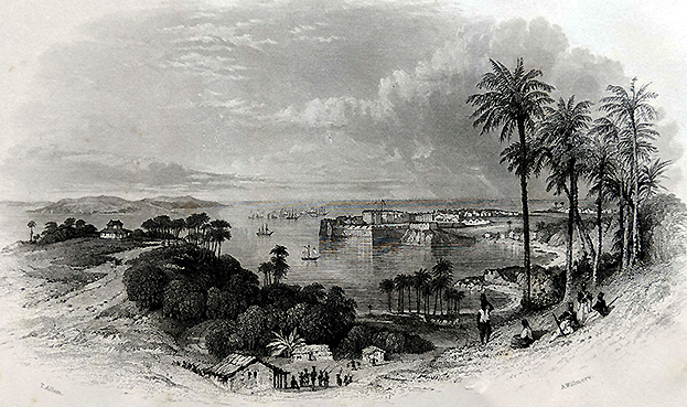 Bombay fort' General view of Bombay. Arthur Willmore --Date: 1840 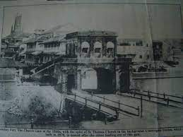 Engraving of a general view of Bombay by Arthur Willmore (1814-88) after Thomas Allom (1804-1872) and dated c.1840. The area of Bombay was originally composed of seven islands. In 1661, these islands were acquired by the British Crown from the Portuguese as part of the marriage dowry of Catherine of Braganza when she married Charles II. From 1668, the East India Company leased the land from the British Crown and developed the area as a trading port. A manor house of the Portuguese, situated on Bombay Island, provided a suitable site for the fort. A custom house, warehouse, quay and fortifications were also built soon after. In the 18th century, the town surrounding the fort was developed. This included the contruction a number of public buildings, the creation of outer fortifications and the clearance of land surrounding this area. In this view, the flagstaff within this area is shown. By the 1860s, the need for military defence lessened and Governor Sir Bartle Frere demolished the fort walls. As a result, Bombay underwent an ambitious phase of building in the Victorian style. 'View in Basseen Fort'. Captain James Barton's 12 Views of Hill Forts in the Western Ghats near Bombay, London, c.1820.Artist: Barton, James, Capt (1793-1829)--Medium: Lithograph Date: 1820   A TEMPLE NEAR TO PORTUGESE CHURCHES IN THE BASSEIN FORT[VASAI FORT]1820 Coloured lithograph of a view in Bassein Fort by Rudolph Ackermann (1764-1834) after Captain James Barton (1793-1829) plate 7 of Barton's 12 Views of Hill Forts in the Western Ghats near Bombay published in London c.1820. Bassein (Vasai) is situated at the mouth of the Ulhas River north of Bombay. In 1534, the Portuguese seized Bassein from Bahadur Shah, the Sultan of Gujarat, and the town remained in their control for just over 200 years. At the height of its prosperity, Bassein had 5 convents and 13 churches. In 1739, Bassein was taken by the Marathas. In 1802, the British secured the Treaty of Bassein with Peshwa Baji Rao II, which allowed British forces to be stationed in Maratha territory. Sewri Fort, Bombay, looking across to Trombay Island. An officer, probably a self portrait, is shown sketching   Date: 1828--Artist: Miller, William (1795-1836)  Pen and ink drawing of Sewri Fort in Bombay looking across to Trombay Island by William Miller (1795-1836) in 1828.The image is inscribed: 'Suree from below the Band hill. Bandalah. W.M. December 1828'. Sewri Fort was located on the eastern shore of Parel Island and constructed in 1770. Parel Island, along with Trombay, was one of seven that originally made up the area of Bombay. The artist, William Miller, had a house at Parel. It was located at Vadalla between the towns of Sewri and Matunga. In this view an officer is shown sketching on the left. This figure is probably a self portrait of the artist.
 Photograph of Kalbadevi, Bombay from 'Views in the island of Bombay' by Charles Scott,1850s. The area of Kalbadevi was named after the shrine dedicated to the goddess Kali in this area. In the 18th and 19th century, Hindu immigrants from Gujarat, Kathiawar, Kutch and Marwar moved to Bombay to escape famine and drought in their homelands and settle in Bombay, where there was economic growth and prosperity. Kalbadevi was one of the areas where they settled. Some of the houses drew inspiration from Gujarat or Rajasthan, the areas where the residents came from. Kalbadevi was also a busy commercial centre with the Gujarati and Marwari Jewellers conducting their business and as a centre for trade in cotton and metals. Cotton stores, Bombay.-Date: 1855-Photographer: Johnson and Henderson  
A photograph of a view of a cotton warehouse, Bombay from the 'Vibart
Collection of Views in South India' taken by an unknown photographer
about 1855.Before the mid 19th Century, India used to export cotton to
Britain, and then reimport cloth. The impetus towards the founding of a
cotton industry came from Indian entrepreneurs; the first mill, ‘The
Bombay Spinning Mill’, was opened in 1854 in Bombay by Cowasji Nanabhai
Davar. Opposition from the Lancashire mill owners was eventually offset
by the support of the British manufacturers of textile machinery. Cotton
exports from India took off during the American Civil War, when
supplies from the USA were interrupted. Bombay, from Malabar Hill-date: 1855--Photographer: Johnson and Henderson  
A photograph of a view of Bombay from Malabar Hill from the 'Vibart
Collection of Views in South India' taken by an unknown photographer
about 1855. Originally, Bombay was composed of seven islands separated
by a marshy swamp. It’s deep natural harbour led the Portuguese settlers
of the 16th Century to call it Bom Bahia (the Good Bay). The British
Crown acquired the islands in 1661when Catherine of Braganza married
Charles II, as part of her marriage dowry. It was then presented to the
East India Company in 1668. The second governor, Gerald Aungier,
developed Bombay into a trading port and centre for commerce and
inducements were offered to skilled workers and traders to move here. please note:- The second governor, Gerald Aungier, developed Bombay into a trading port and centre for commerce and inducements were offered to skilled workers and traders to move here.  BOMBAY-1850-MALABAR HILL -Photographer: Scott, Charles Photograph looking at the eastern part of Malabar Hill, Bombay from 'Views in the island of Bombay' by Charles Scott,1850s. Malabar Hill, the highest point in Bombay, is where the Silhara Kings (r.810-1260) founded the original Walkeshwar Temple. The temple was destroyed by the Portuguese and rebuilt in 1715 by Rama Kamath. By 1860, the temple attracted many people and there were 10 to 20 other temples around it and 50 dharamshalas. Fairs were held near the temple. Mountstuart Elphinstone built the first Bungalow in Malabar Hill during his governorship from 1818 to 1827. After this many more people built houses here and the area became a posh locality which it still remains.  WILD ANIMALS INCLUDING TIGERS WERE REPORTED ON MALABAR HILL 1850 .
Malabar Hill was named so in the early days of British rule as it housed
a military battery to foil a fleet of pirates operating from Malabar
who would lie in wait to attack commercial vessels. .
The Malabar-Cumbala Hills were tropical forests, which had a good
population of wild animals like snakes, pythons, monkeys and the elusive
tiger.  Bombay 1881-VIEW FROM MALABAR HILL was possibly taken looking east from Cumbala Hill. BASSEN FORT(VASAI FORT) BOMBAY-1780 The British Library says that it is a "Pen-and-ink and wash drawing of the Fort of Bassein in Maharashtra by Charles Reynolds (c.1756-1819) in 1780. BOMBAY-1675-PEOPLE AND BUSINESSIn
1661, the islands of Bombay passed to the British Crown, when Charles
II married Catherine of Braganza. However, the Portuguese garrison in
Bassein refused to part with the islands of Salsette, Parel, Worli
and Mazagaon. 
This list does not exhaust all the islands that have merged into the modern city of Bombay. In particular,Salsette, the large northern island which remained under Portuguese control till 1739, is not counted among these seven. British soldiers captured these islands only in 1665, and a treaty was signed in the manor house on the island of Bombay. The
British East India Company received it from the crown in 1668 for the
sum of 10 pounds a year, payable every September 30. Sir George Oxenden,
then President of the factory in Surat, became the first Governor of
Bombay. The Company immediately set about the task of opening up the
islands by constructing a quay and warehouses. A customs house was also
built. Fortifications were made around the manor house, now renamed
Bombay Castle. A Judge-Advocate was appointed for the purpose of civil
administration. Sir George died in 1669. Gerald
Aungier was appointed the President of the Surat factory and Governor
of Bombay in 1672, and remained at this post till 1675. He offered
various inducement to skilled workers and traders to set up business in
the new township. As a result, a large number of Parsis, Armenian,
Bohras, Jews, Gujarati banias from Surat and Diu and Brahmins from
Salsette came to Bombay. The population of Bombay was estimated to have
risen from 10,000 in 1661 to 60,000 in 1675. The first four governors held Bombay for the Crown:-
Gerald
Aungier established the first mint in Bombay. In 1670 the Parsi
businessman Bhimjee Parikh imported the first printing press into
Bombay.  Aungier planned extensive fortifications from Dongri in the north to Mendham's Point (near present day Lion Gate) in the south. However, these walls were only built in the beginning of the 18th century. The harbour was also developed, with space for the berthing of 20 ships. In 1686, the Company shifted its main holdings from Surat to Bombay. During
the Portuguese occupation, Bombay exported only coir and coconuts. With
the coming of many Indian and British merchants, Bombay's trade
developed. Soon it was trading in salt, rice, ivory, cloth, lead and
sword blades with many Indian ports as well as with Mecca and Basra. Life India-- Elephants Stable--in Hampi Bullock powered Mill---Bullock cart -- Hill Fort of Mhowle-Lithographer: Ackermann, Rudolph (1764-1834) Medium: Lithograph Date: 1820 Coloured lithograph of the Hill Fort of Mhowle in the Western Ghats in Maharashtra by Rudolph Ackermann (1764-1834) after an original drawing by Captain James Barton (1793-1829). Plate 8 of 'Captain James Barton's 12 Views of Hill Forts in the Western Ghats near Bombay' published in London c.1820. The Western Ghats are a range of hills that reach from the state of Maharashtra to Tamil Nadu and separate Bombay, on the western coast, from central India. This view shows a British encampment in front of a large outcrop of rock at Mowle. The artist, Captain James Barton, was an artillery officer who served in the third Anglo-Maratha war in 1817-19.  Hill Fort on the Island of Caranjah-near BOMBAY-Artist: Forbes, James Medium: Engraving Date: 1813From Salsette near Bombay, Forbes(1749-1819) sailed to Karanja and landed about two miles from the principal town, situated between two lofty mountains, on the west. He observed that it was: 'nothing more than a large Mahratta village, with low-straggling houses, near a tank covered with wild ducks and water-fowls, hitherto unmolested by Europeans. On its bank a small fort, a Portuguese church and a Hindoo temple embellished the view. It commands a western view of the town and harbour of Bombay, Salsette and all the adjacent islands, and to the east the mountains of the continent, and nearer plains of Caranjah; abounding in rice-fields, coco-nut, palmyra, mango and tamarind trees, filled with monkeys, parrots, owls, and singing-birds of various kinds'. The Fort of Visiadroog - Southern Koncan. One of a series of Views in India and in the vicinity of Bombay  Lithographer: Spreat, William (fl. mid-19th century)Medium: LithographDate: 1850 Lithograph of the
Fort at Vijayadurg by William Spreat after an original sketch by Robert
Pouget and one of a series of 'Views in India and in the vicinity of
Bombay' dated c.1850 and published in London. The
Fort at Vijayadurg is located at the mouth of the Vaghotan creek on the
western coast of India between Goa and Bombay. The fort, built by the
Adil Shahi dynasty of Bijapur, was strengthened and enlarged by the
Maratha ruler Shivaji from 1669. While main entrance to the fort on the
landward side was protected by outworks and a moat, the inner circuit of
walls include 20 towers and rise to the height of 36m. 1858-BOMBAY FORT Commencement of the Reservoir, in the Valley of Vehar, Island of Salsette," Illustrated London News, 1856* 1770-BOMBAY The Strait Between the Islands of Bombay and Salsette(before mahim causeway/bridge was made) by William Carpenter (1818-99). Watercolour on paper.
A general view of a British station Date: 1860. Image from Mary Evans - Prints Online BELOW;-Lord Hastings' flotilla on the river, with many pinnace budgerows--Artist: Sita Ram (fl. c.1810-1822) Medium: Watercolour Date: 1814  A View of Black Wall with part of the Yard--Artist: Dodd, R Medium: Engraving Date: 1789Dodd,
the artist, explained: "This view was taken at the launch of the Bombay
Castle, a 74-gun ship built at the expence of the Hon[ora]ble East
India Company and presented by them to His Majesty. Blackwall is the
most eminent place on the river Thames for building and equipping ships
for the service of the Honb.le East India Company. The Dockyard has been
considered as the East India Yard from the year 1608 and at this time
more capacious than any other private yard in the Kingdom or probably in
the world…"
1908-RIOT OUTSIDE ESPLANADE COURT ;BEFORE TRIAL OF CONGRESS LEADER B.G.TILAK A Hindoo Fair, a wood engraving from the Illustrated London News, 1858 | |||||||||||||||||||||||||||||||||||||||||||||||||||||||||||||||||||||||||||||||||||||||||||||||||||||||||||||||||||||
 - HMS 'Shannon' Taking USS 'Chesapeake', 1 June 1813 - BHC0601 - Royal Museums Greenwich")
 - HMS 'Shannon' Taking USS 'Chesapeake', 1 June 1813 - BHC0602 - Royal Museums Greenwich")
 underway on 17 June 1963 (NH 97620)")
 underway at sea on 17 June 1963 (NH 97621)")


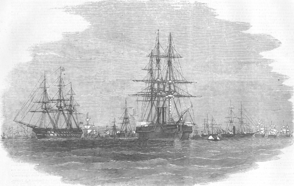
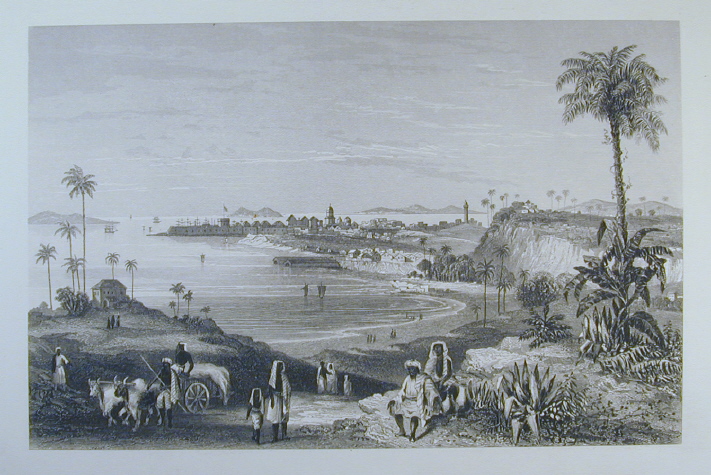
Bombay (Mumbai) Cotton Market - 1869 ...
in.pinterest.com
AND BELOW PICTURE SHOWS RELIGIOUS SERVICE OF 'JAINS' IN BOMBAY
agefotostock.com
2 comments:
wonderful
Amazing blog post and loved going through it
Thanks
Rgds
TR
Chennai
Post a Comment