Saturday, December 19, 2020


"General Sir Charles Napier, of Sind, called by the natives Satan's Brother," a sketch by Isabel Burton, from her book 'Arabia, Egypt, India: A Narrative of Travel', 1879

*A view of Hyderabad in the Scinde. Sir Charles Napier in the foreground followed by his escort of Scinde horse. Lithograph by Capt. Sir Augustine Fitzgerald, c.1850* (BL)


"The Battle of Meeanee" (1843), a steel engraving by Armitage and Allen, 1855


The newly-founded "Punch" published a cartoon in which Napier claimed his victory by saying "PECCAVI" (in Latin, "I have sinned"). More discussion: *VictorianWeb*


"Launch of the 'Meanee', 80 guns, at Bombay," from the Illustrated London News, 1849


"Entrance of Sir William Mansfield into Jacobabad, Scinde," from the Illustrated London News, 1865


== Indian Routes index == Indian Routes sitemap == Glossary == FWP's main page ==


"Launch of the 'Meanee', 80 guns, at Bombay," from the Illustrated London News, 1849


Thursday, December 17, 2020


BOMBAY, the "Bom Bahia," 1534 onwards


*MAP*
Section 10, on the coast-- you really can't miss it
Some early maps of the area; it's now of course called "Mumbai"
The fort at Bassein, to the north of Bombay proper, was the Portuguese headquarters from 1534 until the Marathas overpowered it in 1739
By the late 1600's, the British East India Company in Bombay was minting its own coins; in 1687, Bombay became the new Company headquarters (replacing Surat)
Parsis too have always been prominent in Bombay history
Bombay as it looked in early paintings and engravings
Street life in Bombay: some lively drawings from the later 1800's
In the 1800's Bombay acquired some monumental civic architecture
The remarkable Municipal Corporation building
Victoria Terminus, the great railway station, was in a class by itself
Flora Fountain, another of the city's famous landmarks
Bombay was not immune from the famines of the late 1800's
Street life in Bombay in photographs, later 1800's and early 1900's
The Gateway of India, quintessential symbol of Bombay, was completed in 1924
Modern downtown Mumbai-- a spectacular panoramic view


**Maps of the Gulf of Cambay area**


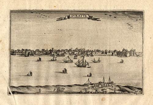
"Logie van Suratte," the headquarters building of the Dutch East India Company, from 'Pieter van den Broecke's Voyages to West Africa and Asia 1605-1630' by Isaac Commelin, Amsterdam, 1646; with *a very large scan of this engraving*; also: *"Suratte"*

Source: ebay, Aug. 2010


A coastal map for pilots from 'Le petit flambeau de la mer', 1650's

Source: ebay, Apr. 2009


*"Surat," from 'Asia: the first part... The Vast Empire of the Great Mogol and Other Parts of India...' by John Ogilby, London, 1673*

Source: ebay, Mar. 2013

"Surate ou Suratte," from *MALLET*, first German edition, 1685 (with later hand reprints)

Source: ebay, May 2006


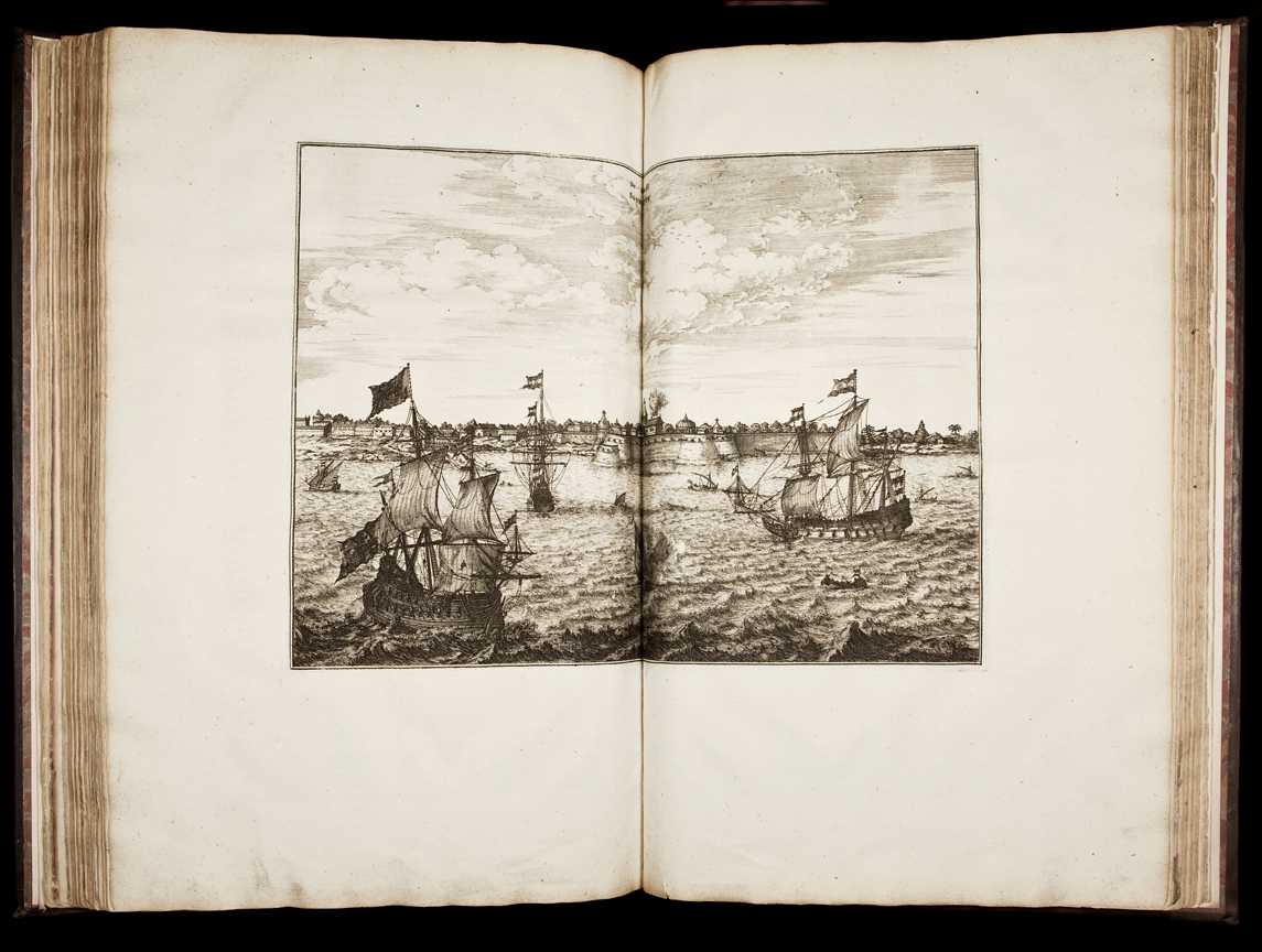
A depiction of the British factory in Surat, after the English had supplanted the Dutch (compare the Dutch "logie" above); a French engraving, c.1725; and here's *a page with a very large scan of this engraving*

Source: ebay, May 2007


A view from Henri Abraham Chatelain's 'Atlas Historique', c.1720

Source: ebay, Jan. 2007


*La Ville de Suratte, dans l'Empire du Mogol; by Pieter Boudewin van der Aa, 1720* (BL)


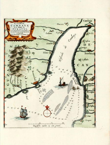
"The Gulf of Cambay and the Road of Surat,"a navigation map by Pieter van der Aa from 'La Galerie Agreable du Monde (...).Tome premier des Indes Orientales.', published by P. van der Aa, Leyden, c. 1725.

Source: ebay, Feb. 2012


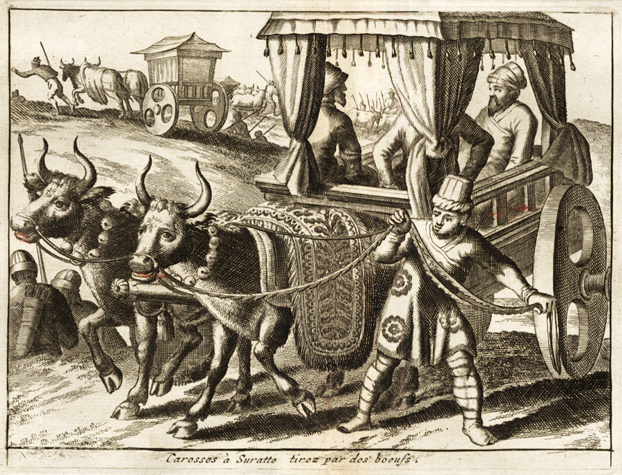
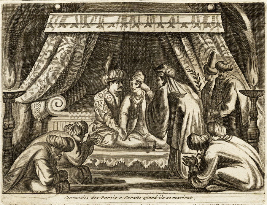
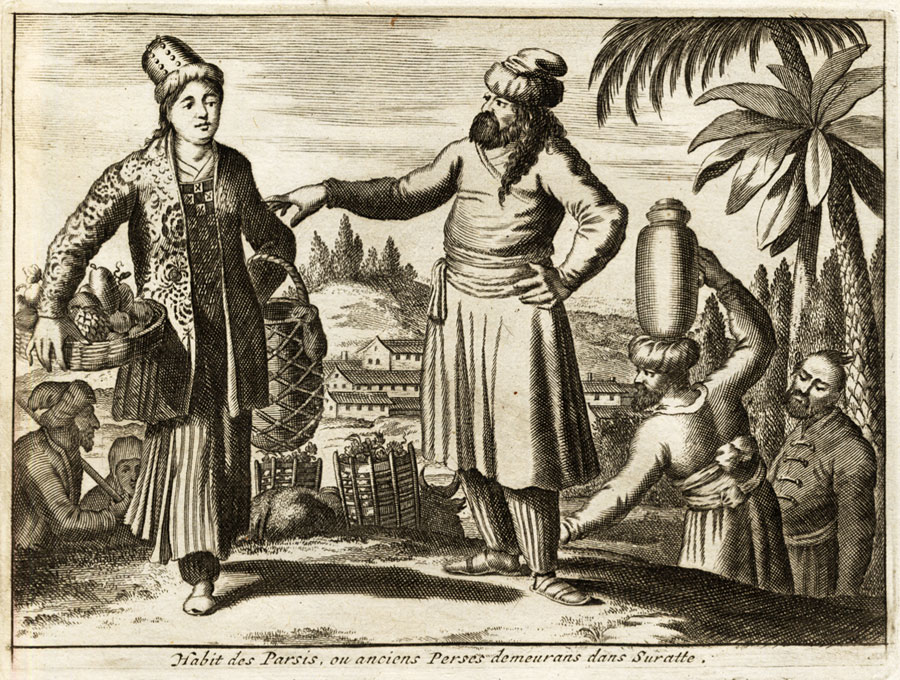
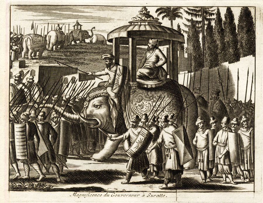
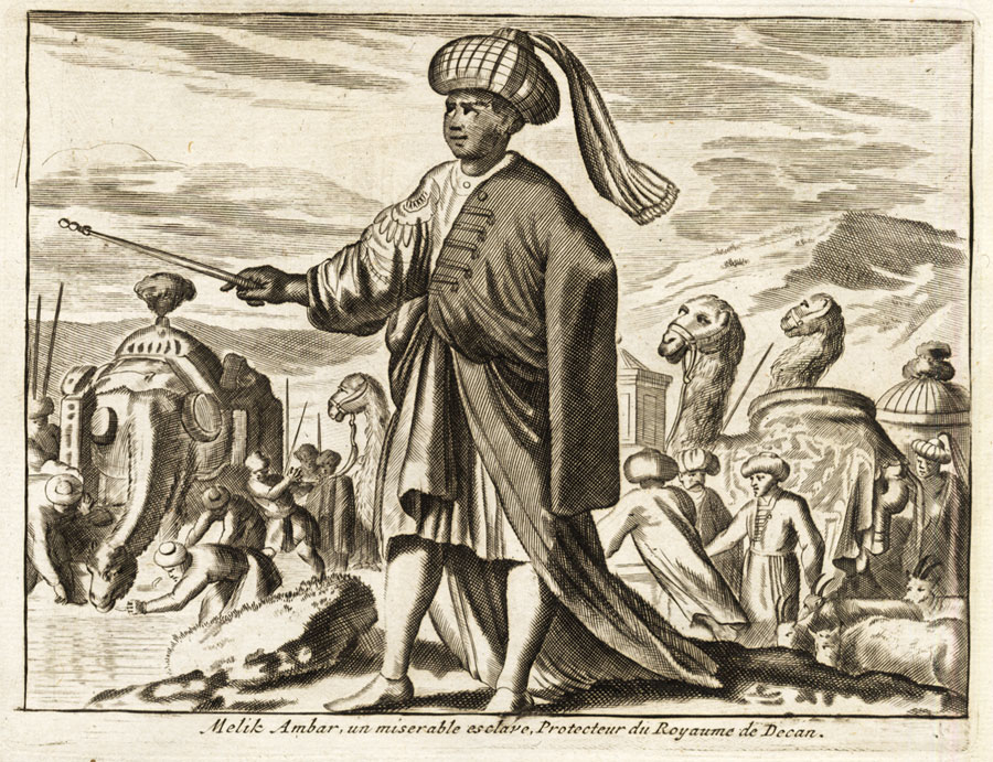
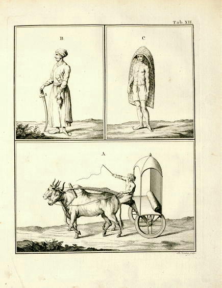
Two residents of Surat, with the city in the background; by van der Aa, from 'La Galerie Agreable du Monde (...).Tome premier des Indes Orientales.', Leyden, c. 1725; also:
*"Carosses a Suratte, tirez par des boeufs"*;;
*"Ceremonies des Parzis a Suratte quand ils se marient"*;
*"Habit des Parsis, ou anciens Perses demeurans dans Suratta"*;
*"Magnificence du Gouverneur a Suratte"*;
*"Malik Ambar, un miserable esclave, Protecteur du Royaume du Deccan"*

Source: ebay, Feb. 2012

"Magnificence of the Governor at Surat," from 'Voyages Celebres et Remarquables faits de Perse etc., by Jean Albert de Mandelslo,' 1727

Source: ebay, Nov. 2007


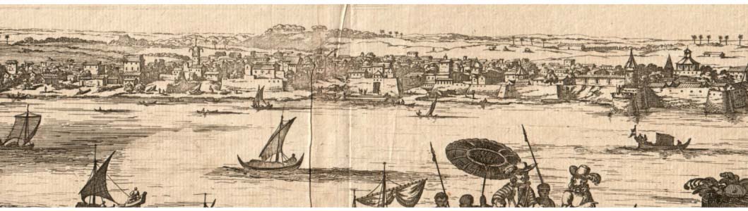
A view by Philip Baldaeus, from 'A True and Exact Description of the most Celebrated East-India Coasts of Malabar and Coromandel; as also of the Isle of Ceylon', London, 1744; *a closer view of the town itself*

Source: ebay, Sept. 2005


*"View of Surat from the bank of the river," by Bellin, c.1751*, from *PREVOST*

Source: ebay, Nov. 2011


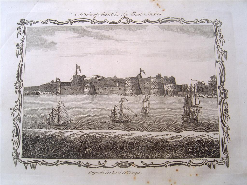
*"A View of Surat," in a copper engraving by Edward Rooker, c. 1770*

Source: ebay, Dec. 2005


*From: 'A New Universal Collection of Voyages and Travels, from the Earliest Accounts to the present time', by Edward Cavendish Drake (London: Cooke, 1771)*

Source: ebay, July 2006


*Inhabitants of Surat; a view from 'Description of Arabia' by Carsten Niebuhr, 1776*; also: *Surat and the Gulf of Cambay*

Source: ebay, Sept. 2007


Surat in its setting, from a map by Louis Brion de la Tour, from 'Histoire Universelle depuis le Commencement du Monde', c.1780


A view of the fort from about 1780, with modern hand coloring: *more information (BL)*

Source: http://www.antiqueprints.com/Prints/india_prints.html
(downloaded Feb. 2002)


From a Surat-to-Bombay map by Benard, from Pierre de Pagès' 'Voyages Autour Du Monde', Paris, 1782

Source: ebay, Nov. 2007


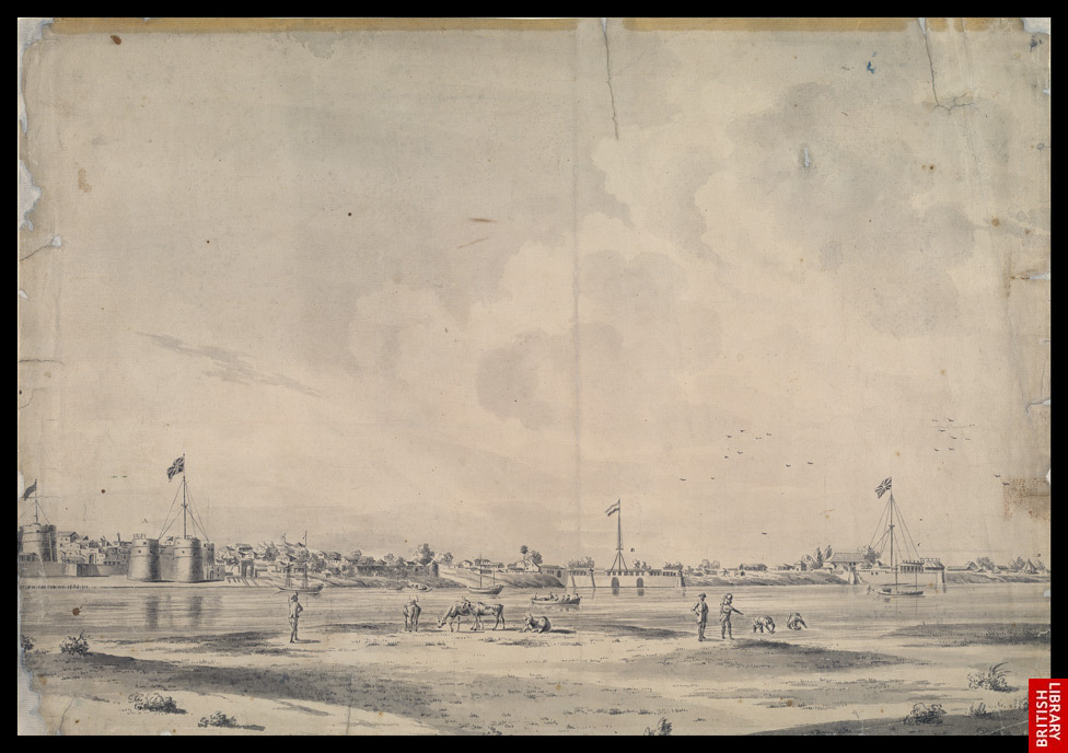
*View of Surat from across the River Tapti; by A. van der Heen, 1782* (BL); [*van der Heen, 1782*]


*"Surat in the East Indies," an engraving, 1814*

Source: ebay, May 2007


*Panorama of Surat, a colored aquatint by Alfred Robert Freebairn, 1830* (BL)


"Surat on the Banks of the Tappee," an engraving from 1834

Source: ebay, Feb. 2009

Click &read:- The Pirates of Malabar,

 The Pirates of Malabar,

by John Biddulph   (1907)
=========== 

== *Introduction by FWP*
== *Views of the Malabar Coast*
== *Author's preface*

*Chapter I: The Rise of European Piracy in the East*

Portuguese pirates--

From the Gulf of Cambay on down the Malabar Coast, c.1700's-1850's: ports (with forts)


MAPS of the Malabar Coast during this period; *maps of the Gulf of Cambay region*
Nieuhoff's early depictions of Malabarians, 1703
On a promontory in southern Gujarat was the Portuguese fort of DIU
SURAT had been the Mughals' chief port, but it was gradually supplanted by colonial-period ports to the south of it (including, over time, Bombay)
South of Surat was the Portuguese fort of DAMAN
*BOM-
BAY*
Bombay, on the "good bay" that the British had acquired from the Portuguese, was growing rapidly, protected by its Bassein Fort

Just a bit south of Bombay was the Siddis' island fort of JANJIRA, which lived on piracy and was never conquered by any Indian or colonial power
Then, as we move further southward, came DABUL
Next the small fort that Bellin calls "Andarajapour," that seems to be RAJAPUR
Then came GERIAH, at the heart of what was sometimes called the "Pirate Coast"; for a vivid account see *The Pirates of Malabar*
The small port of VENGURLA was an early Dutch settlement (1638)
*GOA*
Next came the Portuguese stronghold of Goa
Just to the south of it was ONORE (modern Honavar), an English fort besieged by Tipu Sultan in 1784
BARCELORE was one of the smaller port towns
MANGALORE came next
A bit further to the south was CANANORE
TELLICHERRY was an early English spice trading center, from 1638 until 1794
Next came the small French fort of MAHÉ
Then there was CALICUT (modern Kozhikode), a longstanding and important trading center, though by this time on the decline
Then came CRANGANORE [Kodungallor]; near it once lay *Muziris*, an important Roman trading port
COCHIN was, like Goa, Daman, and Diu, an early Portuguese trading center
QUILON was one of the last links in the chain, before Cape Comorin
Finally came ANJENGO, another early English trading center like Tellicherry (1684)