
WALES, James (1747-1795)
View from Sion Fort
Used with permission from the Peter Anker Collection held in the Kulturhistorisk Museum at the University of Oslo, Norway.
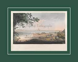
Plate 10: View from Sion Fort, 1791-1792.
James Wales prepared two views of Bombay and its environs from within the walls of Sion Fort. In this first Plate [No. 10] there is a panoramic view over the islands and saltpans of the Bombay archipelago. The view looks down from the Sion Fort gate to Bombay and the Neat's Tongue, bounded by the Mahratta Mountains. James Wales infuses the scene with strong domestic setting, depicting a squatting Indian sepoy (possibly smoking a bhang pipe), with his wife nursing a baby, a small child, dog, and two bullocks (for pulling a two-wheel carriage) in a courtyard outside their modest dwelling beside the fort ramparts. The coastline and horizon are barely distinguishable in the suffused light, though in the middle distance the scene is punctured by the distinctive silhouettes of the coconut palms.
The original Sion Fort was built between 1669 and 1677 by the second British governor of Bombay, Gerard Aungier (c1635-1677), on top of a conical hillock, and it marked the northeast boundary between the British-held Parel Island and Portuguese-held Salsette Island.
Macquarie Connection
Lachlan Macquarie recorded in his journal on 5 October 1789 that he had visited Sion:
Lachlan Macquarie recorded in his journal on 5 October 1789 that he had visited Sion:
I went upon a very pleasant Party today, along with Col. and Mrs. Stirling, and Mr. and Mrs. Herring, and a number of Gentlemen, to Meham, [sic] and Sion Fort, where we dined and spent a very agreeable day; From the Fort on Sion Hill, which commands a most extensive view, we had a most charming Prospect of every part of the Island of Bombay, the neighbouring Islands, and Continent, which along with the variety of breaks of water intervening, forms a most beautiful and very Picturesque Scene; Sion Fort is Nine Measured Miles from Bombay Fort and is one of the Extremities of the Island, – being divided only by a very narrow channel from the large Island of Salcet, [sic] belonging also to the Presidency of Bombay. —
I travelled to Sion in a Palanquin, having Eight Bearers – a very easy and comfortable mode of Travelling in this Country. — We all returned in the Evening to Bombay. —"
WALES, James (1747-1795)
View from Sion Fort


Used with permission from the Peter Anker Collection held in the Kulturhistorisk Museum at the University of Oslo, Norway.
Plate 11: View from Sion Fort, 1791-1792.
In this second Plate [No. 11] James Wales provides an alternative panoramic view from the Sion Fort. From the vantage of Sion Fort, the view opens out to the island of Mahim. In this scene the walls of the fort dominate the foreground, with the curving line of the ramparts and an imposing cannon mounted in the battlement wall. The rising staircase and buildings behind the gun carriage are surmounted by a flagstaff asserting British sovereignty over the island. In other versions of this Plate there is no flag suspended on the flagstaff, so its inclusion here is an intriguing anomaly [cf: coloured etching held by Yale Center for British Art, listed as Plate 11, dated 1800, London].
The figures descending the stairs provide an ironic yet humorous counterpoint to the scene. There is the stout portly figure of an English military official whose waist is bursting from his red uniform, clearly the figure of a buffoon. He is accompanied by a European woman whose hand he holds; behind them follow two figures, one of whom is a woman carrying a small child. The status of these other women is unclear. The companion is clearly a figure of affection, while the woman in blue is presumably a nanny or wetnurse to the child. A one-legged, one-armed sepoy veteran stands waiting to greet the group, thereby highlighting the additional use of the fort as a sepoy hospital or hospice for military veterans. Once again the flat lands below the fort stretch into the indeterminate distance under a wide dominating sky. There are buildings and plantation areas with associated coconut palms in the middle distance, as well as thick clusters of native trees. On the far right of the picture, though significantly trimmed in this versio, is a pagoda, tomb or sati pavilion.
References:
Oxford Dictionary of National Biography. [See entry: 'Gerald Aungier (c1635-1677)'].
de ALMEIDA, Hermione and GILPIN, George H. Indian Renaissance: British Romantic Art and the Prospect of India. Ashgate, 2005 pp.130-131.
Oxford Dictionary of National Biography. [See entry: 'Gerald Aungier (c1635-1677)'].
de ALMEIDA, Hermione and GILPIN, George H. Indian Renaissance: British Romantic Art and the Prospect of India. Ashgate, 2005 pp.130-131.
WALES, James (1747-1795)
View From the Island of Elephanta

Used with permission from the Peter Anker Collection held in the Kulturhistorisk Museum at the University of Oslo, Norway.
Plate 12: View From the Island of Elephanta, 1791-1792.
Plate 12 is the final view in the posthumous series of works by James Wales. In this scene Bombay and its adjoining islands are barely discernible. They float in the middle distance, almost invisible, upon a smooth calm sea, under a high canopy of cloud and blue sky. The foreground is dominated by the well-known black rock elephant sculpture at that time located outside the entrance to the namesake Elephanta cave-temple. This massive elephant towers over the scene, though intriguingly, along with the temple pagoda depicted in Plate 11, it represents the only other example of Indian antiquity depicted by Wales in his perspectives of Bombay and its islands. This absence, or artistic restraint, is noteworthy when compared to other contemporary artists who often embellished their landscapes with exotic cultural examples to enhance their works. The number and variety of monuments and artefacts available throughout the region was quite significant so we must assume that Wales' interest was directed towards other modes of representation. It was not a case that he lacked interest in architectural drawings, for he spent the years 1793-1794 visiting and sketching monumental sites of interest throughout the Poona and Ellora districts, as well as on the island of Salsette. And it was on a visit to the caves and antiquities of Salsette in October 1795 that Wales caught the fever from which he eventually died on 18 November 1795.
The caves and rock-cut temple are the focal point of Gharapuri Island, and subsequently renamed Elephanta Island by the Portuguese. The island is located in the inlet formed between the original outer islands of Bombay and the mainland. It is approximately five miles in circumference and the smallest, but also purportedly, the oldest of the cave-temples of western India. [see: de Almeida and Gilpin, G. Indian Renaissance pp.47-55 and Note 32]. The temple site covers an area of approximately 60,000 sq ft (5,600 sq. m.) and contains reliefs, sculptures, and a sanctuary dedicated to the Hindu god Siva, and dated to the sixth century AD. It consists of a main chamber, two lateral ones, courtyards and subsidiary shrines. However none of this is visible in this work by James Wales. It is the remoteness, antiquity, and the spiritual richness of the sculptures at Elephanta, compared to those visible at Kanheri on Salsette island and at Ellora on the mainland, that drew Wales back here on regular field trips.
Although the large sculpture of an elephant with a tiger on its back was located near the main portico of the temple complex and Wales' depiction does not include this detail in his rendering of the scene. Even in the time of his artistic predecessor, James Forbes (1745-1819), the sculpture had suffered from exposure and damage, and in 1864 it was relocated to Victoria Gardens, Bombay.
The figure of the elephant was an important artistic as well as archaeological object and an important account was recorded by historian and orientalist William Erskine (1773-1852) in the Transactions of the Bombay Literary Society in 1819. The description replicates almost exactly the viewpoint presented in the engraving by James Wales:
"...The celebrated caves of Elephanta are situated in the beautiful island of that name, which is called by the natives Gara-pori: it lies in the bay of Bombay, about seven miles from Bombay Castle and five miles from the Mahratta shore. It is nearly six miles in circumference, and is composed of two long hills with a narrow valley between them. The usual landing-place is towards the south, where the valley is broadest.
About two hundred and fifty yards to the right of the landing-place, on the rising side of one of the hills not far from a ruined Portuguese edifice, stands a large and clumsy elephant cut out of an insulated black rock; –– from this the island has taken its present name. The elephant has a fissure running through its back, which is separated so that the back has sunk a little downward upon the fore-flank. Captain Pyke, in his account of the Caves, written in 1712,* [see: Archaeologia Vol. vii. p.323] mentions that this elephant had a smaller one on its back. An engraving of both as they stood at that time may be found in Archaeologia; from which it appears that even then the fissure had begun to appear, and had nearly reached upwards to the top of the back. Anquetil ** [see: Zendavesta, Ouvrage de Zoroastre &c. Vol. i. p.423] describes the young elephant as existing in 1760, when he visited Elephanta. Niebuhr [see: Voyages de Niebuhr. Vol. ii. p.33] observes, that the large elephant had on its back something which age had worn so much that it was impossible to distinguish what it was, and that the large elephant was split, and even then (1764) expected to fall to pieces. The figure is poorly sculptured but at a distance and seen through the brushwood may easily be mistaken for a real elephant.
In September 1814 (after the above was written) the head and neck of the elephant at last dropped off, and the body of the elephant has since sunk down and threatens to fall. I had however, in the November preceding, taken an accurate measurement of all its dimensions in company with Captain Basil Hall of the Royal Navy, to whose friendship I owe the annexed very accurate drawing of its appearance at that time (Plate I). It seems to have been formed of a detached mass of blackish rock, which is unconnected with any stratum below. By applying a ladder we mounted the back of the elephant, for the purpose of observing if any traces remained of the young elephant, said by Pyke and Anquetil to have been placed on it. The remains of its four paws, as well as the marks of the juncture of its belly with the back of a larger animal, were perfectly distinct; and the appearance it offered in the annexed drawing made by Captain Hall (Plate II), who from its present appearance conjectures that it must have been a tiger rather than a young elephant; an idea in which I feel disposed to agree … as well on account of the sprawling appearance of the animal, as because the back of the mother is a very unnatural situation for a young elephant; and because the supposition of its being a tiger would correspond much better with the popular legends of the Hindus..."
Erskine, William. 'Account of the Cave-Temple of Elephanta, with a Plan and Drawings of the Principal Figures'. Transactions of the Bombay Literary Society. pp. 198-250 [see: pp.207-208].
A second point of interest in the engraving by Wales appears in the centre of the picture where there is a mixed group of European visitors and a large company of Indian servants. A military officer in a red jacket, accompanied by a European woman and a small child are walking towards the Caves, sheltering from the sun under a large parasol held over them by an Indian attendant. The possibility has been raised by Dorothea Hysing [2002] that these figures are in fact Major-General Peter Anker (1744-1832), the Danish governor of Tranquebar, accompanied by his companion, the British widow Mrs Mallard and her son. Anker remained at this post from 1788 until 1805. The engraving may have been produced by Wales as a tribute to their relationship. Mrs. Mallard died in May 1791 two months prior to the arrival of Wales in Bombay; however Hysing speculates that Wales may have known Mrs. Mallard in London and/or alternatively Anker during the time when he was the Danish Consul-General for Britain [1783-1786]. (See: p.88) Wales and his wife and children had moved to London by 1783, where he is known to have exhibited two portraits at the Society of Artists.
Behind the trio of Europeans can be seen two palanquins whose bearers are standing and squatting on the ground, relaxing from their recent labours. Near the shoreline a boat has recently disembarked more visitors. They can be seen walking along a rocky promontory, assisted by local Indians who carry various chairs and accoutrements for their outing to Elephanta. As with the other views by Wales the scene is punctuated in the foreground and middle distance by an assortment of native vegetation and coconut palms. Wales wrote that this image was: "Taken from the Landing-Place of this celebrated Island, exhibiting the colossal statue of the Elephant whence it is named, including the little island of Butcher on the right." The rock-cut temples dating to some 6th century AD on this island are dedicated to the Hindu deity Shiva in the form of Mahadeva.
Macquarie Connection
Macquarie visited the island of Elephanta on 9 October 1790, ten months prior to Wales' arrival in India, though it is unclear whether this was his first visit to the island:
Macquarie visited the island of Elephanta on 9 October 1790, ten months prior to Wales' arrival in India, though it is unclear whether this was his first visit to the island:
Saturday. I spent a very pleasant Day on an Excursion to Elephanta Caves, along with Col. Balfour and some other Brother Officers.
Source:
Twelve Views of Bombay and its Vicinity. London: R. Cribb, 1800.
Twelve Views of Bombay and its Vicinity. London: R. Cribb, 1800.
WALES, James (1747-1795)
View from Belmont
Used with permission from the Peter Anker Collection held in the Kulturhistorisk Museum at the University of Oslo, Norway.
Plate 8: View from Belmont, 1791-1792.
[Mazagaon, Bombay, to the south]
In the distance can be seen the flagstaff at Bombay Fort. The dockyard and Harbour are barely discernible, though ships can be seen moored in the Harbour. The view shows the islands of Bombay, part of the village of Mazagaon, and the Mahratta mountains in the background. The top of Belvidere House and Cross Island are on the left, to the right is Fort George, and across the water lay Chaul and Kanheri.
Source:
Twelve Views of Bombay and its Vicinity. London: R. Cribb, 1800.
Twelve Views of Bombay and its Vicinity. London: R. Cribb, 1800.
Unfortunately, the related Plate 9. View from Belmont, 1791-1792. [Mazagaon, Bombay, to the north] is NOT held in the University of Oslo. Kulturhistorisk Museum. Peter Anker Collection.
WALES, James (1747-1795)
View from Belmont

Used with permission from the Peter Anker Collection held in the Kulturhistorisk Museum at the University of Oslo, Norway.
Plate 7: View from Belmont, 1791-1792.
[Mazagaon, Bombay, to the east]
James Wales prepared three views from Belmont or Mazagoan Hill. This Plate and its associated views are dominated by numerous spindley coconut trees in the foreground and middle distance, reaffirming Bombay's local reputation as the 'Isle of Palms'. The view in Plate 7 is looking eastward towards distant mountains on the mainland. Below the hill can be seen an assortment of buildings and warehouses and paddy fields. In the foreground a figure is halfway up the trunk of a coconut palm collecting coconuts, while below another man is carrying a cluster of harvested coconuts that are suspended from his shoulder on a pole. The island in the middle distance is probably Butcher's Island, behind which, obscured from sight, lay the island of Elephanta.
The view shows "Belmont toward the beach of the Harbour, including part of the village of Mazagon, the islands of Carranjar, Elephanta and Butcher, bounded by the hills". At this time Mazagaon was an outlying suburb of Bombay, and a fashionable place to live in the late 18th century. The crowded Fort area encouraged the British - and more affluent Indians such as the Wadias - to build bungalows and plantation houses here in a location where they could enjoy the fresh, cooler air and a higher vista over the landscape.
Source:
Twelve Views of Bombay and its Vicinity. London: R. Cribb, 1800.
Twelve Views of Bombay and its Vicinity. London: R. Cribb, 1800.
WALES, James (1747-1795)
View of the Breach Causeway

Used with permission from the Peter Anker Collection held in the Kulturhistorisk Museum at the University of Oslo, Norway.
Plate 5: View of the Breach Causeway.
The Breach Causeway at Mahalaxmi provides a picture of rural tranquillity set beside a flat sandy beach and a circle of calm water amidst the necklace of tidal islands that formed Bombay in the late C18th. The reclamation of the tidal flats would consolidate the area into unified whole in the C19th, but at the time of Wales' rendering of the scene there is a sense of idyllic simplicity.
In the immediate foreground, on the left of the picture, a massive Indian banyan tree rises to frame the picture and provides a commanding reference point. At the right edge of the picture there is a procession of small Indian and English figures moving along the road. In the foreground are three examples of local methods of transportation: a palanquin, a 'Bengal chair', and a myanna (or small litter suspended from a bamboo pole). The palanquin is being carried towards a long causeway at the centre of the picture. Among the dwellings, adjoining the village well and small sandy beach, Indian figures can be seen moving about their daily tasks. A man on horseback is riding towards the causeway.
Two canopied carriages, one of which is horsedrawn, can be seen moving along the roadway embankment. One is heading along Parel Road towards the ancient Mahalakshmi temple, a Hindu and Parsi shrine well known to the inhabitants of the Bombay islands, but not shown in Wales' landscape. The other carriage drawn by two bullocks and is approaching the village to the right of the picture. A small boat in a circle of calm water provides an offset focus to the centre of the image, while beyond, under a pale blue sky, the north-eastern horizon is punctured by the outline of the distant mountains.
This causeway or vellard, north of Cumballa Hill, was commenced in 1782 and completed in 1784 and became known as the Hornby's Vellard. It was one of the first major engineering projects aimed at transforming the original seven islands of Bombay into a single island with a deep natural harbour. The project was started by William Hornby (d.1803) during his governorship of Bombay from 1771-1784. The initiative was carried out against the wishes of the Directors of the Honourable East India Company (HEIC), but to great acclaim by the local inhabitants as it transformed the geography of the islands by opening up the marshy areas of Mahalaxmi and Kamathipura for habitation.
The primary purpose of the causeway was to block the Worli creek and prevent the low-lying areas of Bombay from being flooded by the sea. The causeway formed a crucial connection between north and south Bombay, thereby consolidating the central portion of the island thereby uniting the land north between Mahim and West Parel with the area south of Worli which was normally flooded at high tide.
The word vellard appears to be a local corruption of the Portuguese word vallado meaning 'barrier' or 'embankment'. All the Bombay islands were finally linked by 1838.
Macquarie Connection:
Lachlan Macquarie was familiar with the Breach area and in his journal on the 15 May 1790 he noted that:
Lachlan Macquarie was familiar with the Breach area and in his journal on the 15 May 1790 he noted that:
"I spent this day very agreeably in a Party given by Mr. Page on the Breach water on board of a jung-Gaur, in which we dined and had a Concert."
References:
de ALMEIDA, Hermione and GILPIN, George H. Indian Renaissance: British romantic art and the prospect of India. Ashgate, 2005 pp.128-130.
DWIVEDI, Sharada and MEHROTRA, Rahul. Bombay: the cities within. Bombay: Eminence Designs, 2001 p.28.
YULE, Henry and Burnell, A.C. Hobson-Jobson: a glossary of colloquial Anglo-Indian words and phrases, and of kindred terms, etymological, historical, geographical and discursive. [See entries for: 'vellard' and 'jangar'].
WALES, James (1747-1795)
View of the Breach from Love Grove

Used with permission from the Peter Anker Collection held in the Kulturhistorisk Museum at the University of Oslo, Norway.
Plate 6: View of the Breach from Love Grove.
The island of Worli was connected to the main island of Bombay in 1784, with the completion of the Hornby Vellard. Prior to this, Worli is known to have contained a mosque, the Haji Ali dargah, on a rock in the sea, connected at low-tide to the island by a natural causeway. There was also a fort and a fishing village to the north, close to the island of Mahim. This view shows the perspective from Love Grove Hill on the southern extremity of Worli looking towards the pinnacled Hindu temple at Mahalaksmi. This area became known as the Byculla Flats.
There is a romantic Muslim legend attached to Love Grove, on the right of the view. It concerns two drowned lovers, who today are commemorated in Hadji Ali's mosque.
Source:
Twelve Views of Bombay and its Vicinity. London: R. Cribb, 1800.
Twelve Views of Bombay and its Vicinity. London: R. Cribb, 1800.
WALES, James (1747-1795)
View from Malabar Hill

Used with permission from the Peter Anker Collection held in the Kulturhistorisk Museum at the University of Oslo, Norway.
Plate 3: View from Malabar Hill
[Bombay: part of panorama with Plate 4].
This image forms the left hand side of a two-part panorama. The foreground is dominated by the rocky outcrop at the top of Malabar Hill. In the middle distance can seen the outline of Bombay Fort and the associated town. The islands of Karanja and Elephanta are pictured in the distance, with the Mahratta Mountains in the background.
The sweep of the shoreline of Back Bay and the tidal flats are just visible, though there is no indication of the European burial ground at Sonapur or the recently completed Belassis Road that linked Malabar Hill to Bombay. The buildings in the foreground may include 'Randall Lodge', the country residence of Major-General John Bellasis (1744-1808) HEIC, Commander of the Forces and Colonel of Artillery at Bombay. It was located on the promontory leading to Malabar Point.
What is intriguing about this version is that the thick vegetation overhanging the rock on the left, and the palm leaves on the right, do not appear in the completed two-plate version held in the British Library, or elsewhere. These are embellishments or adornments added by the colourist of this individual Plate, possibly Peter Anker.
Source:
Twelve Views of Bombay and its Vicinity. London: R. Cribb, 1800.
Note: Plate 4: View from Malabar Hill [Bombay, part panorama with 3] is not held in the University of Oslo, Kulturhistorisk Museum, Peter Anker Collection]. The remainder of the panoramic view extends across the western half of Back Bay, and includes Old Woman's Island, the lighthouse, Mendham's Point, and the Flag Staff at Malabar Point.
View of Bombay harbour. View of Bombay harbour as seen from the quayside near the Custom...

- Image number
- BL3308470
- Image title
- View of Bombay harbour. View of Bombay harbour as seen from the quayside near the Custom House; boats in the water; figures on the docks. Etched 'No2' in lower right-hand corner below image. This plate and plate No1 form a panorama.
- Location
- British Library, London, UK
- Image description
[Bombay Views. Twelve Views of the Island of Bombay and its Vicinity: taken in the years 1791 and 1792]: [designed and engraved on the spot by James Wales; and brought to this country by Sir Charles Warre Malet]. Author: Wales, James / Illustrator: Wales, James [London]: [Published by R. Cribb], [1800] Source/Shelfmark: Maps 7 TAB.20. no.2
- Photo credit
- From the British Library archive