volcano (geology) :: Hot springs and geysers -- Encyclopedia ...
www.britannica.com/EBchecked/topic/632130/.../Hot-springs-and-geyse...
Hot springs and geysers also are manifestations of volcanic activity. ... Yellowstone National Park in the United States is one of the most famous areas of hot springs and geysers in ... Hot springs and geysers · Volcanism and tectonic activity.
......................................................................................................................................

Youth drowns in hot water springs lake in Manor
MUMBAI: A youngster drowned in a natural hot water springs lake in
Sativali of Manor after he suffered an epilepsy attack on Monday
evening.
The charred body was found on Tuesday.
Deepak Gaikar (20) a resident of Lokmanya Nagar in Thane entered the hot springs lake in Varai village in Sativali, around 95km from Mumbai. In the water he suffered an epilepsy attack and drowned.
.....................................................................................................................................

Geysers are hot springs that intermittently spout a column of hot water and steam into the air. This action is caused by the water in deep conduits beneath a geyser approaching or reaching the boiling point. At 300 metres (about 1,000 feet) below the surface, the boiling point of water increases to approximately 230 °C (450 °F) because of the increased pressure of the overlying water. As bubbles of steam or dissolved gas begin to form, rise, and expand, hot water spills from the geyser’s vent, lowering the pressure on the water column below. Water at depth then momentarily exceeds its boiling point and flashes into steam, forcing additional water from the vent. This chain reaction continues until the geyser exhausts its supply of boiling water.
After a geyser stops spouting, the conduits at depth refill with groundwater, and reheating begins again. In geysers such as Yellowstone’s Old Faithful, the spouting and recharge period is quite regular. This famous geyser has gushed to heights of 30 to 55 metres (100 to 180 feet) about every 90 minutes for more than 100 years. If Old Faithful’s eruption lasts only a minute or two, the next interval will be shorter than average, while a four-minute eruption will be followed by a longer interval. Other geysers have much more erratic recharge times.
The charred body was found on Tuesday.
Deepak Gaikar (20) a resident of Lokmanya Nagar in Thane entered the hot springs lake in Varai village in Sativali, around 95km from Mumbai. In the water he suffered an epilepsy attack and drowned.
.....................................................................................................................................
Deccan Traps - Wikipedia, the free encyclopedia
en.wikipedia.org/wiki/Deccan_Traps
The bulk of the volcanic eruption occurred at the Western Ghats (near Mumbai) some 65 million years ago. This series of eruptions may have lasted less than ...Geysers are hot springs that intermittently spout a column of hot water and steam into the air. This action is caused by the water in deep conduits beneath a geyser approaching or reaching the boiling point. At 300 metres (about 1,000 feet) below the surface, the boiling point of water increases to approximately 230 °C (450 °F) because of the increased pressure of the overlying water. As bubbles of steam or dissolved gas begin to form, rise, and expand, hot water spills from the geyser’s vent, lowering the pressure on the water column below. Water at depth then momentarily exceeds its boiling point and flashes into steam, forcing additional water from the vent. This chain reaction continues until the geyser exhausts its supply of boiling water.
After a geyser stops spouting, the conduits at depth refill with groundwater, and reheating begins again. In geysers such as Yellowstone’s Old Faithful, the spouting and recharge period is quite regular. This famous geyser has gushed to heights of 30 to 55 metres (100 to 180 feet) about every 90 minutes for more than 100 years. If Old Faithful’s eruption lasts only a minute or two, the next interval will be shorter than average, while a four-minute eruption will be followed by a longer interval. Other geysers have much more erratic recharge times.
It was no volcanic activity on Sunday in Baramati, say experts
Thursday, May 15, 2008, 3:06 IST
The
mystery behind the geological eruption at the Murti village in Baramati
taluka on Sunday remained unsolved, even as a three-member geologists'
team from Pune visited the place.
Witnesses say a lava-like substance was oozing out from the six-inch radius hole
BARAMATI: The mystery behind the geological eruption at the Murti village in Baramati taluka on Sunday remained unsolved, even as a three-member geologists' team from Pune visited the place on Wednesday and ruled out any volcanic activity.
The team from Deccan Volcanological Society (DVS) was led by its president Anant Phadke.
After inspecting the spot thoroughly, Phadke said, "The eruption is neither a volcano nor an earthquake. Villagers need not worry."
"Onlookers have stepped on the spot and have destroyed vital clues. We should have visited the spot much early. We have taken a few samples of the solidified matter," Phadke said.
When asked why the area was not cordoning off to keep it safe from public interference, police sub-inspector Rajendra Kale said he had informed the higher authorities about the incidence. "Tehsildar Sameer Shingte visited the place on Monday," he said.
Confirming that it was not a natural phenomenon, DVS secretary Sampada Joshi said, "The melting of rock-like substances had taken place at the electricity pole. It later solidified in the form of hard matter."
Explaining a possibility, she said since the eruption occurred at the bottom of an iron electricity pole, perhaps it has to do with electricity. The molten lava-like fluid may have taken place due to residual current under the earth surface.
According to witnesses, a lava-like substance was oozing out from the six-inch radius hole.
Akbar Pathan, who was among the first to visit the spot after the eruption, said initially there was hot, brown fluid and vapour was continuously
coming out.
Sunil Nalawade, in whose field the incident took place, said that he saw the eruption of a red-hot fluid.
"The government authorities will decide their next course of action after studying the geologists' report," said Sub-divisional officer Nandkumar Katkar.
|
Volcanic Eruption Articles By Date
INDIA
October 20, 2013 |
IMPHAL:
A suspected volcano-like eruption has been reported in a remote village
of Manipur near the India-Myanmar border which forced locals to
evacuate the area, official sources said on Sunday. According to
locals in Tusom village in Ukhrul district of Manipur, a deafening sound
was followed by the rolling down of a huge boulder from a nearby
hilltop which then released a lava-like liquid that charred trees and
plants on the hill slopes. Although the incident...
Volcanoes in India, not meteorite, killed dinosaurs: Study - Economic ...
articles.economictimes.indiatimes.com › Collections
Dec 9, 2012 - NEW YORK: Volcanic activity in the Deccan Traps near modern-day Mumbai, and not an asteroid, may have killed the dinosaurs about ...Volcanoes in India, not meteorite, killed dinosaurs: Study - Economic ...
articles.economictimes.indiatimes.com › Collections
Dec 9, 2012 - NEW YORK: Volcanic activity in the Deccan Traps near modern-day Mumbai, and not an asteroid, may have killed the dinosaurs about ...
Coastal ecosystem responses to late stage Deccan Trap volcanism:
the post K–T boundary (Danian) palynofacies of Mumbai
(Bombay), west India
J.A. Cripps
a,
*
, M. Widdowson
b
, R.A. Spicer
b
, D.W. Jolley
c
a
School of Earth Sciences and Geography, Kingston University, Kingston-upon-Thames, KT1 2EE, United Kingdom
b
Department of Earth Sciences, The Open University, Milton Keynes, MK7 6AA, United Kingdom
c
Centre for Palynology, University of Sheffield, Sheffield, S3 7HF, United Kingdom
Received 24 March 2004; received in revised form 23 August 2004; accepted 12 November 2004
Abstract
The Deccan Trap continental flood basalt eruptions of India occurred c. 67–63 Ma, thus spanning the Cretaceous–Tertiary
boundary (65 Ma). Deccan eruptions were coeval with an interval of profound global environmental and climatic changes and
widespread extinctions, and this timing has sparked controversy regarding the relative influence of Deccan volcanism upon end-
Cretaceous catastrophic events. If Deccan Trap activity was capable of affecting global ecosystems, evidence should be present
in proximal Indian sedimentary facies and their palaeontological contents. The impact of late stage Deccan volcanism upon
biota inhabiting Mumbai (Bombay) Island’s post K–T boundary lagoonal systems is documented here. Sediments (or
b
intertrappeans
Q
) which accumulated within these lagoons are preserved between Trap lavas that characterise the closing stages
of this flood basalt episode.
Mumbai Island Formation intertrappean faunal and floral communities are conspicuously distinct from those common to
many pre K–T boundary, late Maastrichtian intertrappeans across the Deccan province. The latter sedimentary intercalations
mostly developed in cognate semiarid, palustrine ecosystems; by contrast, those around Mumbai evolved in sheltered,
peripheral marine settings, within subsiding continental margin basins unique to this late Deccan stage, and under an
increasingly humid Danian climate. Geochemical analyses reveal that Mumbai sedimentation and diagenesis were intimately
related to local explosive volcanic and regional intrusive activity at c. 65–63 Ma. Although tectonic and igneous events
imprinted their signatures throughout these sedimentary formations, organisms usually sensitive to environmental perturbations,
including frogs and turtles, thrived. Critically, palynofacies data demonstrate that, whilst plant material deposition was
responsive to environmental shifts, there were no palpable declines in floral productivity following Mumbai pyroclastic
discharges. Therefore, it is implausible that this late stage explosive volcanism influenced major ecosystem collapses globally.
D
2004 Elsevier B.V. All rights reserved
Volume 172, Issues 1–2, 10 May 2008, Pages 3–19
Physical Volcanology of Large Igneous Provinces

Research paper
Correlation of the Deccan and Rajahmundry Trap lavas: Are these the longest and largest lava flows on Earth?
Choose an option to locate/access this article:
Check if you have access through your login credentials or your institution
Check accessAbstract
We propose that the Rajahmundry Trap lavas, found near the east coast of peninsular India,
are remnants of the longest lava flows yet recognized on Earth
(∼ 1000 km long). These outlying Deccan-like lavas are shown to belong
to the main Deccan Traps. Several previous studies have already
suggested this correlation, but have not demonstrated it categorically.
The exposed Rajahmundry lavas are interpreted to be the distal parts of
two very-large-volume pāhoehoe flow fields, one each from the Ambenali
and Mahabaleshwar Formations of the Wai Sub-group in the Deccan Basalt
Group. Eruptive conditions required to emplace such long flows are met
by plausible values for cooling and eruption rates, and this is shown by
applying a model for the formation of inflated pāhoehoe sheet flow
lobes. The model predicts flow lobe thicknesses similar to those
observed in the Rajahmundry lavas. For the last 400 km of flow, the lava
flows were confined to the pre-existing Krishna valley drainage system
that existed in the basement beyond the edge of the gradually expanding
Deccan lava field, allowing the flows to extend across the subcontinent
to the eastern margin where they were emplaced into a littoral and/or
shallow marine environment. These lavas and other individual flow fields
in the Wai Sub-group may exceed eruptive volumes of 5000 km3, which would place them amongst the largest magnitude effusive eruptive units yet known.
We
suggest that the length of flood basalt lava flows on Earth is
restricted mainly by the size of land masses and topography. In the case
of the Rajahmundry lavas, the flows reached estuaries and the sea,
where their advance was perhaps effectively terminated by cooling and/or
disruption. However, it is only during large igneous province basaltic
volcanism that such huge volumes of lava are erupted in single events,
and when the magma supply rate is sufficiently high and maintained to
allow the formation of very long lava flows. The Rajahmundry lava fields
were emplaced around 65 Ma during the later times of Deccan volcanism,
probably just after the K/T environmental crisis. However, many
lava-forming eruptions of similar magnitude and style straddled the K/T
boundary.
Keywords
Figures and tables from this article:
Copyright © 2007 Elsevier B.V. All rights reserved.
Deccan Volcano - John Seach
|


 |
Roadmap | Home |
|
|
Deccan traps |
|


Why the Deccan Traps are Important!
 The
timing of when the bulk of the eruptions occurred, 65 million years
ago, is interesting because this is at the same time as what is known as
the K-T boundary. Found in the rock at the K-T boundary is the presence
of enriched iridium, an element rare in Earth's crust but abundant in
meteorites. An impact event now identified at what is named Chicxulub Crater
is widely believed to have caused the extinction of the dinosaurs.
There is strong evidence though that this could not have been the only
factor though. So scientists are now looking at the Deccan Traps as a
contributing factor perhaps in the extinction of the dinosaurs.
The
timing of when the bulk of the eruptions occurred, 65 million years
ago, is interesting because this is at the same time as what is known as
the K-T boundary. Found in the rock at the K-T boundary is the presence
of enriched iridium, an element rare in Earth's crust but abundant in
meteorites. An impact event now identified at what is named Chicxulub Crater
is widely believed to have caused the extinction of the dinosaurs.
There is strong evidence though that this could not have been the only
factor though. So scientists are now looking at the Deccan Traps as a
contributing factor perhaps in the extinction of the dinosaurs. The impact of the meteorite at Chicxulub Crater would have caused massive damage around the Earth and triggered an impact winter. The Deccan Traps would have contributed a further global 2°C drop in temperature and the realease of massive amounts of sulphuric gasses into the atmosphere. There is data supporting a killing off of foraminifera with the main eruptions at the Deccan Traps.
| Find the Deccan Traps and so many more features on our Satellite World Map. |  |
 |
|
| Check it out NOW! |
|
||||
|
||||
| Click here to
go to Discussion of this page
|
||||
|
1.
Impetus for this
contribution
The Deccan volcanic
province (DVP) is one of the world's largest LIPs
and perhaps the best studied continental flood basalt
(CFB). However, its genesis and evolution are still
poorly understood.
Recently, Sheth
(1999) convincingly refuted the plume model as a basis
for the genesis of the DVP (see The
Deccan beyond the plume hypothesis). However,
his suggestion that the DVP and Laccadive-Chagos ridge
formed as a consequence of southward crack propagation
along the Vishnu fracture zone is not consistent with
data concerning the geomagmatic and tectonic history
of the Indian peninsular plate. The current status
of knowledge thus represents a shortfall of understanding.
The need to fill this gap in our knowledge, and to
establish a genetic model for the DVP based on the
vast volumes of existing scientific data, was the
impetus for the present contribution.
2.
Introduction
The DVP is one of the
Earth's giant continental flood basalts and has a
total exposed area of about half a million square
kilometers, between latitudes 16° -
24° N and longitudes 70° - 77° E.
In the northwestern, central and southern Indian peninsula,
the approximate volume of the DVP is about 2 x 10⁶
km3 and its estimated age is 64-65 Ma.
It is generally believed that the DVP originated during
Gondwanaland breakup as part of the Seychelles-India
separation event. Another important belief concerning
this CFB is that it is the “head” of a
plume which is currently active as Reunion volcanism,
with the “tail” consisting of the rather
irregular chain of volcanic islands extending from
Reunion to and along the Laccadive-Maldive-Chagos
ridges. The latter model has been refuted convincingly,
as mentioned above. However, a viable alternative
model has not yet been proposed. In this contribution
we attempt to provide an alternative hypothesis based
on existing geological information about the DVP.
3.
The Deccan volcanic province:
existing scientific data
The DVP erupted on the
Archean-Proterozoic shield areas of south, north-west
and central India and the adjoining offshore area
off the west coast (Figure 1) (Devey & Stephens,
1991). The volcanics cover two cratonic areas –
the Dharwar craton of the south Indian shield and
the central Indian craton. Apart from this, the DVP
is associated with four major rift zones of peninsular
India (Figure 1). It is juxtaposed with the east-west-running
Narmada-Satpura-Tapi rift which is a horst-and-graben-type
rift zone that trends ENE-WSW for > 1600 km along
central India (Mishra, 1977). In northwest
India, the DVP is in contact with the Cambay, Kutch
and West Coast rifts.

Figure 1: Geological map showing
the location of the Deccan volcanic province and its
relationship with the geo-tectonic features of the
region. Modified after Sheth (2005).
To evaluate the causes
of DVP genesis, it is essential to understand the
geological context of its hosts. Therefore, to interpret
the data from the Deccan volcanics, we first review
the nature of the hosts.
Along the West Coast
rift, the south Indian shield witnessed several
prior phases of magmatism before it hosted the Deccan
volcanics. The first recorded event occurred at 678
Ma when gabbro, granophyre and anorthosite magmatism
occurred (Nair & Vidyadharan, 1982). This
was followed by granitic plutonism, almost 128 My
later, i.e., at 550 Ma (Soman et al.,
1983). Subsequently, the region hosted pegmatitic
intrusions at 460 Ma (Soman et al., 1982).
These pegmatites mark the end of the major phases
of the magmatic episode because there was then a complete
hiatus of magmatic events in the region until 93 Ma
(date averaged from six differing K-Ar dates), i.e.,
for more than 350 My! At 93 Ma, the West Coast region
again experienced magmatism, this time involving rhyolitic
and dacitic volcanics (Valsangkar et al., 1980).
This was followed by vast mafic volcanism and plutonism
which resulted in the DVP and associated dyke swarms
during the period 64-65 Ma, and covered the huge area
mentioned above.
Along the Narmada-Tapi
rift zone, prior to the Deccan episode, no major
magmatic event is reported. Instead, the horst (Satpura)
and grabens (Narmada and Tapi) paved the way for enormous
sedimentation, which gave rise to the Mahakoshal group
of rocks (Chanda & Bhattacharya, 1966).
These metasediments recorded several phases of shearing
implying that the Narmada – Tapi rift is associated
with intense shear deformation along an east-west
trend. These metasediments are followed by Jurassic-early
Cretaceous sediments on top of which the Deccan volcanics
lie (Chanda & Bhattacharya, op.cit).
The tectonics of
the northwest Indian peninsula and the offshore region
are inter-related. The summary of the tectonic
history of this region given here is based on the
studies of several workers (Glennie, 1932;
Qureshy, 1971; Owen, 1976; Kaila
et al., 1979; 1981; Biswas, 1982; 1987;
Harbison & Bassinger, 1973; Gupta et
al., 1998). As shown in Figure 1, four major rift
zones are in contact with the Deccan volcanics, the
Narmada-Tapi rift, the West Coast rift, the Cambay
rift and the Kutch rift. Kutch rifting occurred in
the late Triassic to early Jurrasic followed by early
Cretaceous Cambay rifting. The Narmada-Tapi and West
Coast rifts were reactivated in the late Cretaceous.
The Narmada-Tapi rift zone is believed to be extending
along its trend into the offshore area of the Indian
west coast.
Concerning geophysics
(Chandrasekharam, 1985), the Bouguer gravity
anomaly pattern and seismic profiles along the West
Coast rift indicate:
Deep Seismic Sounding
(DSS) investigations have been carried out in the
Indian peninsula (Reddy et al., 1999). This
study indicates that the crust seems to become thinner
(24 km) towards the northern parts of the west coast,
that is north of 15°N. The west coast was also
characterized by upwarp of the Moho during the late
Cretaceous period.
Vertical crustal movements
are recognized along the West Coast rift, and shear
displacement along the Narmada-Tapi rift zone and
its extension into the offshore areas (Biswas,
1982).
4.
The new proposed hypothesis: an effort to bridge the
gap in knowledge
4.A:
The first phase of magmatism, 678 to 460 Ma: Of
the four rifts, only the West Coast rift exclusively
hosts magmatic rocks older than the Deccan volcanic
event at 64-65 Ma. These magmatic rocks, which formed
at 678-460 Ma, show a clear trend of fractional melting
(gabbro-rhyolite to pegmatites). This implies the
presence of a magma chamber beneath the Indian lithosphere
under the west coast. In this magma chamber, magma
could have remained stored and preserved its primary
chemistry. The primary magma could have risen from
its depth of segregation which was beneath or within
the west coast lithosphere, but certainly not deeper
than 200 km because the first magmatic event was gabbroic.
The hiatus in igneous activity from 460 Ma
to 93 Ma along the West Coast rift indicates that
during this period the magma pressure in the chamber
was less than lithospheric, and/or the temperature
was too low for magma to cross the liquidus of its
compositions. By 93 Ma, that is 350 My later, this
problem was removed.
4.B The
beginning of the second phase of igneous activity,
at 93 Ma: This phase, along the West Coast rift,
is marked by a magmatic event which was not plutonic,
like previous ones, but rather volcanic. Unlike the
previous episode, it began with magma of felsic composition
– the rhyolites. It is relevant to note that
Madagascar-Indian plate breakup took place at around
93 Ma. This breakup also occurred along the western
continental margin of India. Obviously, such a megascale
rifting event will leave its signature in the form
of volcanic, not plutonic activity, which can explain
the simultaneous rhyolitic volcanism. The composition,
felsic instead of mafic, probably indicates that the
temperature was too low to melt mafic components in
the magma chamber beneath the West Coast region, but
elevated enough to produce the rhyolitic melts, i.e.,
it was around 1000°C.
4.C The
Deccan volcanism, at 64-65 Ma: The second event
of this phase is the Deccan volcanism which occurred
after a hiatus of 30 Ma. Also, after exactly the same
hiatus, and at the same time of 64-65 Ma, the Indian
plate experienced breakup from yet another partner
at Gondwanaland time – the Seychelles. This
probably indicates that the second stage of magmatism,
which began at 93 Ma, was controlled by the breakup
events between Gondwanaland microplates and the Indian
plate. Also, it shows that the breakup process was
a gradual and progressive phenomenon, starting with
Madagascar-India separation and, after another 30
My, Seychelles-India separation. Since this process
controlled West Coast magmatism, which tectonism is
expected to do, we deduce that the magmatism was also
progressive. Thus, we conclude that (i) the rhyolitic
volcanism at 93 Ma resulted from Madagascar-India
breakup, and (ii) that this breakup event was a continuous
process which led to Seychelles-India breakup after
another 30 My and to Deccan volcanism at the same
time. The progressive chemical trend of the volcanics,
i.e., from rhyolite to basalt, indicates
gradual progressive increase in temperature and/or
gradual progressive lowering of the liquidus in the
magma chamber as a result of gradual progressive rifting/breakup
of the Indian plate with Madagascar and the Seychelles
respectively.
The shift from plutonism
during first phase to volcanism during the
second phase perhaps indicates the presence of direct,
uninterrupted conduits from the magma chamber to the
surface of the continental crust during the second
phase. This is what is expected during extensive rifting
events such as Madagascar-India and Seychelles-India
separation which did not occur during the first phase.
The large volume
of the Deccan volcanics and the high rate
of volcanism during the Deccan episode indicate:
Considering that the
West Coast and Narmada-Tapi rift zones were reactivated
at the time of Deccan volcanism and the Cambay and Kutch
rifts were also available as direct conduits for the
upward movement of melt, we infer that the presence
of these four rifts and geophysical evidence of lithosphere
thinning beneath the westen coast explains the size,
volume and eruption rate of the Deccan volcanics.
The geochemical
variation within the Deccan volcanics, as mentioned
above, perhaps indicates differences in the chemistry
of the host rocks. For example, along the Narmada-Tapi
rift zone the magmatic melt must have interacted with
the host sediments, which are Mahakoshal Jurassics
along with Archean metamorphics. Similarly along the
West Coast, Cambay and Kutch rifts, the melt would
have interacted with Archean-Precambrian metamorphics.
Consequential changes in the chemistry would be reflected
in the geochemistry of the DVP volcanics.
4.D
Post Deccan
4.D.1: 61 Ma:
The rifting which had started at 93 Ma resulted in
the opening of the Carlsberg ridge at about 61 Ma.
Deccan volcanism also continued, as suggested by the
age of DVP rocks from the Bombay area (Sheth &
Ray, 2002). This is the time when the Laccadive
ridge also experienced Deccan volcanism.
4.D.2: 55-50 Ma:
Sea-floor spreading along the Carlsberg ridge resulted
in the emplacement of ocean floor between the ridge
and the continental margin of the Indian West Coast.
Deccan volcanism along the West Coast rift produced
the Maldive ridge at around 55 Ma and the Chagos ridge
at around 50 Ma. Clearly, the Maldive and Chagos ridges
formed by interaction of the West Coast rift magma
with Carlsberg ridge mantle magma because the Laccadive
ridge, at 61 Ma, is characterised by melt with the
same chemistry as melt from the magma chamber beneath
the western continental crust of India.
The locations of these
ridges mark the position of India at a given point
in time. At this time, the Indian plate was moving
northwards at a velocity of 18-19 cm/year. Thus, the
position of Indian plate was controlled by (a) its
own velocity in a northerly direction, and (b) the
speed of Carlsberg ridge propagation.
4.D.3: 45-35 Ma:
By this time, the northward movement of India had
slowed considerably because the Indian plate had collided
with the Eurasian plate. As a result, intraplate tectonics
were solely responsible for deformational events.
Along the West Coast rift, two types of forces were
important (Figure 2), the north-south-trending West
Coast and Cambay rift forces and the east-west-trending
Narmada-Tapi rift force. The net vector force of these
two combined resulted in shearing and stretching along
the West Coast rift zone (Figure 2). Simultaneously,
isostatic balancing forces resulting from the emplacement
of a huge volume of volcanics resulted in vertical
movements along the west coast. These conclusions
are based on the fact that the West Coast rift is
bounded by intersecting sets of faults and fractures
which extend up to the Laccadive ridge (Figure 2).
The fracture system north of 16°N formed during
the late Cretaceous whereas the systems to the south
of 16°N formed during the middle to late Tertiary.
This indicates that deformation along the coast had
started in the late Cretaceous and gradually progressed
southwards during the late Tertiary. Probably, the
combined outcome of these forces resulted in Laccadive
ridge separation (due to stretching), southward displacement
(due to shearing) and subsidence (due to isostatic
balancing) during the late Tertiary.

Figure 2: Diagrammatic representation
of the proposed hypothesis described herein for the
geological history of the Indian plate from 65 Ma
onwards. The major stress directions along western
continental margin of India 45-35 Ma are indicated
by red arrows.
Summary
We propose that
a magma chamber underlies the West Coast rift of the
Indian peninsular. In support of this idea, we point
to evidence for continuous magmatism along the west
coast at 678 – 460 Ma, which shows a continuous
trend of fractional melting. This was followed by
a lull in magmatism for almost 350 My. Magmatism started
again at around 93 Ma when Madagascar broke away from
the Indian plate. Since that rifting took place along
the west continental margin of India (i.e. today’s
western coast), we conclude that the associated magmatism
along the western continental margin of the Indian
plate was related to Madagascar-India break up. Rifting
led to decompression which in turn led to partial
melting in the magma chamber beneath the western continental
margin of India. This is supported by the fact that
magmatism during this phase started with felsic volcanism
and not mafic.
As rifting proceeded
along the western margin of the Indian plate, the
rate of partial melting in the magma chamber increased
proportionately leading to the mafic Deccan volcanism.
The high rate of Deccan volcanism was due to the fact
that along with the West Coast rift, three other deep
crustal rifts were activated simultaneously. This
could have been due to continuous rifting along the
west coast from 93 Ma onwards. We propose that the
high volume of Deccan volcanism was because:
We envisage the
magma chamber process to be as follows. A huge magma
chamber progressively accumulates melt, first from
the underlying mantle and eventually from both mantle
and continental crust (by delamination). The molten
material solidifies with time and remains in the chamber
during the period 460-93 Ma. When continental breakup
of greater India starts (including Madagascar rifting
away) the solified magma begins to melt. Since the
melting point of felsic components is lowest, these
are melted first and rhyolites typically comprise
the first phase of volcanics. Alkaline magma is not
initially formed because it has a higher melting point.
Following Deccan volcanism, the Carlsberg
ridge formed and the Indian plate continued to move
north. The systematic time progression of volcanism
between the Carlsberg ridge and the Indian plate is
due to sea floor spreading and not to plate
movement above hotspot.
When the Indian plate collided with
the Eurasian plate, its velocity decreased considerably
and intraplate forces started to play a lead role.
The main forces were then an EW force along the
Narmada-Tapi rift and a NS force along the West
Coast rift. The combined affect of these forces
led to rifting and shearing along the West Coast
rift and resulted in subsidence, pull-apart and
en echelon deformation along the Laccadive
ridge.
To reiterate, the proposition that
~ 106 km3 of Deccan basalts
was erupted from a magma chamber in which it was
stored is radical. However, there are several strong
points that support this suggestion:
We offer these ideas
for further work and discussion.
Acknowledgments
The authors appreciate the continuous
encouragement, valuable discussions and critical
comments of Dr. Harsh K. Gupta, Secretary, Department
of Ocean Development, Government of India and Dr.
P.C. Pandey, Director, NCAOR. The authors are thankful
to Prof. John J. Mahoney who very kindly provided
his critical comments which helped us to improve
the manuscript. We were inspired to work on the
Deccan by the thought-provoking arguments and iconoclastic
views of Dr. H. C. Sheth. We thank our colleagues
at NCAOR for their remarkable contribution all through
the brainstorming sessions and discussions of the
Deccan.
|
Dinosaur Deaths Outsourced to India?
Boulder, CO, USA - A series of monumental volcanic eruptions in India may have killed the dinosaurs 65 million years ago, not a meteor impact in the Gulf of Mexico. The eruptions, which created the gigantic Deccan Traps lava beds of India, are now the prime suspect in the most famous and persistent paleontological murder mystery, say scientists who have conducted a slew of new investigations honing down eruption timing."It's the first time we can directly link the main phase of the Deccan Traps to the mass extinction," said Princeton University paleontologist Gerta Keller. The main phase of the Deccan eruptions spewed 80 percent of the lava which spread out for hundreds of miles. It is calculated to have released ten times more climate altering gases into the atmosphere than the nearly concurrent Chicxulub meteor impact, according to volcanologist Vincent Courtillot from the Physique du Globe de Paris.
Keller's crucial link between the eruption and the mass extinction comes in the form of microscopic marine fossils that are known to have evolved immediately after the mysterious mass extinction event. The same telltale fossilized planktonic foraminifera were found at Rajahmundry near the Bay of Bengal, about 1000 kilometers from the center of the Deccan Traps near Mumbai. At Rajahmundry there are two lava "traps" containing four layers of lava each. Between the traps are about nine meters of marine sediments. Those sediments just above the lower trap, which was the mammoth main phase, contain the incriminating microfossils.
Keller and her collaborator Thierry Adatte from the University of Neuchatel, Switzerland, are scheduled to present the new findings on Tuesday, 30 October, at the annual meeting of the Geological Society of America in Denver. They will also display a poster on the matter at the meeting on Wednesday, 31 October.
Previous work had first narrowed the Deccan eruption timing to within 800,000 years of the extinction event using paleomagnetic signatures of Earth's changing magnetic field frozen in minerals that crystallized from the cooling lava. Then radiometric dating of argon and potassium isotopes in minerals narrowed the age to within 300,000 years of the 65-million-year-old Cretaceous-Tertiary (a.k.a. Cretaceous-Paleogene) boundary, sometimes called the K-T boundary.
The microfossils are far more specific, however, because they demonstrate directly that the biggest phase of the eruption ended right when the aftermath of the mass extinction event began. That sort of clear-cut timing has been a lot tougher to pin down with Chicxulub-related sediments, which predate the mass extinction.
"Our results are consistent and mutually supportive with a number of new studies, including Chenet, Courtillot and others (in press) and Jay and Widdowson (in press), that reveal a very short time for the main Deccan eruptions at or near the K-T boundary and the massive carbon dioxide and sulfur dioxide output of each major eruption that dwarfs the output of Chicxulub," explained Keller. "Our K-T age control combined with these results strongly points to Deccan volcanism as the likely leading contender in the K-T mass extinction." Keller's study was funded by the National Science Foundation.
The Deccan Traps also provide an answer to a question on which Chicxulub was silent: Why did it take about 300,000 years for marine species to recover from the extinction event? The solution is in the upper, later Deccan Traps eruptions.
"It's been an enigma," Keller said. "The very last one was Early Danian, 280,000 years after the mass extinction, which coincides with the delayed recovery."
Keller and her colleagues are planning to explore the onset of the main phase of Deccan volcanism, that is, the rocks directly beneath the main phase lavas at Rajahmundry. That will require drilling into the Rajahmundry Traps, a project now slated for December-January 2007/2008.
WHEN & WHERE
Main Deccan Volcanism Phase Ends at K-T Mass Extinction: Evidence from the Krishna-Godavari Basin, SE IndiaColorado Convention Center Room 506
Tuesday, October 30, 11:00 a.m. - 11:15 a.m.
[ view abstract ]
Paleoenvironment After Main Deccan Volcanism Ended at K-T Mass Extinction: Evidence From The Krishna-Godavari Basin, SE India.
Colorado Convention Center Room 407
Tuesday, October 30, 11:15 a.m. - 11:30 a.m.
[ view abstract ]
Age and Paleoenvironment of Deccan Volcanism and the K-T Mass Extinction
Colorado Convention Center Exhibit Hall E/F
Wednesday, October 31, 8:00 a.m. - 12:00 p.m.
[ view abstract ]
CONTACT INFORMATION
Gerta KellerProfessor, Dept. of Geosciences
Princeton University, Guyot Hall, Princeton, NJ 08544, USA
Email: gkeller@princeton.edu
Telephone: 609-258-4117
Thierry Adatte
Professor, Geological Institute
University of Neuchatel, Neuchatel, CH-2007, Switzerland.
Email: Thierry.Adatte@unine.ch
Telephone: 41 32 726-2617
Cell phone: 41 79 371-2715
Sunil Bajpai
Professor, Department of Earth Sciences
Indian Institute of Technology, Roorkee 247 667, Uttarakhand, India
Email: sunilbajpai2001@yahoo.com
For information and assistance during the GSA Annual Meeting, 27-31 October, contact Ann Cairns in the onsite newsroom, Colorado Convention Center Room 604, +1-303-228-8486, acairns@geosociety.org.
ADDITIONAL SOURCES
1) Regarding the dating of 80 percent of the Deccan Traps to within 300,000 years of the K-T boundary and the greenhouse gas releasesAnne-Lise Chenet
Cambridge University, UK
Email: alc69@cam.ac.uk
Vincent Courtillot
Director, Institut de Physique du Globe de Paris
Université Paris 7, et Institut Universitaire de France, Paris.
Email: courtil@ipgp.jussieu.fr
Telephone: 0033(0)14427-3908
Frederic Fluteau
Professor, Institut de Physique du Globe de Paris
Université Paris 7, et Institut Universitaire de France, Paris.
Email: fluteau@ipgp.jussieu.fr


Most popular articles
History Carved Out of the Deccan Traps
Ancient cave temples carved out of the Deccan basalts are some of the best places to view both the world-renowned Deccan Traps and the Indian mythology narrated on these rocks.
 This statue of Shiva depicts four faces representing Mahadeva (the calm “great lord,” central figure), Aghora (the frightful or destructive aspect of Shiva, on the left), Uma (the beautiful feminine aspect, on the right), and Nandin (the sacred bull as the mouth or doorkeeper of Shiva, not visible). This sculpture is in Cave No. 1 on Elephanta Island. Photo: Rasoul Sorkhabi |
The Deccan Traps, one of the Earth’s largest igneous provinces, cover over 500,000 km2 of west-central India. Erupted about 66 million years during the extinction of the dinosaurs, these flood basalts, in cooperation with the sea, rains and rivers, have shaped the landscape of west-central India. Ancient cave temples have been carved out of the Deccan basalts in many places and the Elephanta Caves located on a small island offshore Mumbai (Bombay) is one such place.
Flood Basalts in Central India
The triangular peninsula of India is largely a Precambrian shield, with a central flat area, the so-called Deccan Plateau, surrounded by the mountain ranges of the Eastern and Western Ghats. The name Deccan is derived from the Sanskrit word ‘dâkshin’, meaning “south.” The west-central parts of the Indian peninsula are dominated by flood basalts which form a prominent terraced landscape; this form of flood basalt is called ‘trap’, after the Dutch-Swedish word ‘trappa’, meaning ‘stairs’.A large number of geochronological data have been reported from the Deccan Traps over the past four decades, and the data cluster between 69 and 63 Ma (corresponding to the magnetic polarity epochs of 31 Reverse and 28 Normal) suggests that the main phase of eruption was at 66.9 ±0.2 Ma, shortly before the Cretaceous-Tertiary (K-T) boundary at 65.5 ±0.2 Ma. This age range is also consistent with paleontological data from the interbedded sediments. Aside from terraces, the Deccan basalts also form numerous dikes, some of which represent the youngest phase of the volcanic activity. While some scientists support a several million year duration, others have argued that the eruption occurred within a million years at the K-T boundary.
The original extent of the Deccan Traps has been estimated as 1.5 million km3, but the latter is highly imprecise as erosion on land and undersea subsidence on the western Indian margin have altered the rock volume accessible to us. The Deccan Traps are thickest on the Western Ghat Range (over 2,000 km thick) or in fault-bounded grabens in west-central India, but become thinner (less than 100 m) close to the margin of the trap province. Over 95% of these lavas are tholeiitic basalts (tholeiite, named after Tholey, Germany is a type of basalt rich in silica). Mantle xenoliths in the Deccan Traps have been reported from a few places.
Most scientists believe that the Deccan Traps poured out as the Indian plate, on its northward journey after the Gondwana breakup, passed over the Reunion hotspot, a still active volcanic island located in the south-west Indian Ocean. Coeval with (or probably as a result of) this event, there was also a continental rift-drift between India and the Seychelles Islands. Indeed, flood basalts of similar age also occur on the Seychelles. (For Seychelles see the article “An Oil Prone Frontier Basin,” GEO ExPro, Vol. 4, No. 3). The occurrence of petroleum reservoirs below the Deccan Traps remains unexplored.
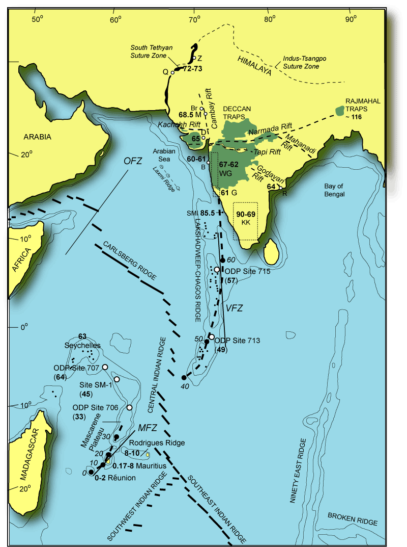
 Distribution of the Deccan Traps in India and their linkage in space and through time to the Reunion Hotspot. Inset: A simple paleotectonic sketch map showing the outpouring of the Deccan basalts at 66 Ma (K-T boundary) related to the impingement of Reunion plume beneath the Indian continental plate, and subsequent rifting between Seychelles and India. Image: Rasoul Sorkhabi |
 A view of two of the caves on Elephanta Island. The Deccan basalts are prominently seen in the photo. Photo: Rasoul Sorkhabi |
Cave Temples in Deccan Traps
One can see exposures of the Deccan Traps in the Indian states of Gujarat, Madhya Pradesh, and Maharashtra in India, but vegetation, soil cover, and land development often mask these rocks. Cliffs of lavas on the Western Ghats and hill caves in Maharashtra perhaps provide the best outcrops to examine these formations. The hill caves are particularly important as many of these are also ancient Hindu or Buddhist temples, centuries old and portraying the Indian myths on rocks.Some of the best known Deccan Trap caves are close to Mumbai (Bombay), including Ajanta (perhaps the oldest one dating back to 200 B.C.), Mandapesvara Caves, Kanheri Caves, Jogeshwari Caves, Mahakali Caves, and of course, the Elephanta Caves, which are our subject here.
 Cave No. 1 or the Great Cave is the largest and most celebrated of all the Elephanta caves. This cave temple (restored in the 1970s) contains many statutes and sculptures of Lord Shiva and his life stories in Hindu mythology. Photo: Rasoul Sorkhabi |
 |
Elephanta Island
The Elephanta Caves are located on Elephanta Island, offshore Mumbai, precisely 11 km north-west of Apollo Bunder near the Gateway of India, where numerous ferries take visitors to the island daily. The entire island, about 2.5 km long and 7 km in circumference, is made up of the Deccan basalts, covered with trees and bushes. Three villages on the island house a few thousand people engaged in farming, fishing, and tourism.Through centuries, the island has come under the rule of various Indian dynasties. In 1534, the Portuguese occupied it. In 1661, when Charles II of England married Catherine of Braganza, daughter of King John IV of Portugal, Elephanta Island was given to the British royal court as a marriage dowry, thus beginning British control of the island until 1947, when India gained independence.
The native name for the island is “Gharapuri” – the “town of Ghari priests (those priests belonging to the Shudra or laborer and artisan class, and devoted to Lord Shiva). But the Portuguese called it Fontis (Elephanta) after a huge elephant statute that once stood on the island.
There are seven temple caves. The first five, on the western part of the island, are Hindu temples dedicated to Shiva, a deity which along with Brahma (‘creator’) and Vishnu (‘preserver’) forms the supreme Hindu pantheon. Shiva - literally the ‘Auspicious One’- is often translated as the ‘lord of destruction’ but as one observes his various sculptures in Elephanta Caves he plays a far more varied role in Hindu mythology. The rock architecture of these Hindu caves has been dated between the 5th and 8th centuries.
The other two caves are Buddhist temples dating back to the 3rd century or even older and are not open to visitors. The Buddhist Stupa on the eastern part of the island is the highest point of the island; it is called the Stupa Hill and is about 173m in elevation.
The Elephanta Caves were originally colour-painted but today only traces remain on the bare rock. Much damage has been done to the caves through centuries of weathering but also by the Portuguese soldiers who fired shots into the caves (to test the echo of their big guns), thus breaking some sculptures and pillars. In 1909, the Elephanta Caves came under the authority of the Archaeological Survey of India, and in 1987 UNESCO included it in the World Heritage list.
A trip to Mumbai is not complete without a visit to the amazing Elephanta Islands, where a portion of India’s ancient history and mythology are preserved and displayed by the Deccan basalts – a fine sight, especially for geologists.
 The stepped nature of the layered basalts of the Deccan Traps is clearly seen inland at Matheran, 90 km from Mumbai Photo: Nichalp, via Wikimedia Commons |

Get This Document Now


Deccan plume, lithosphere rifting, and volcanism in Kutch, India
- a Florida International University, Miami, FL 33199, USA
- b Department of Geological Sciences, University of South Carolina, Columbia, SC 29208, USA
- c Presidency College, Kolkata, India
Choose an option to locate/access this article:
Check if you have access through your login credentials or your institution
Check accessAbstract
Kutch
(northwest India) experienced lithospheric thinning due to rifting and
tholeiitic and alkalic volcanism related to the Deccan Traps K/T
boundary event. Alkalic lavas, containing mantle xenoliths, form
plug-like bodies that are aligned along broadly east–west rift faults.
The mantle xenoliths are dominantly spinel wehrlite with fewer spinel
lherzolite. Wehrlites are inferred to have formed by reaction between
transient carbonatite melts and lherzolite forming the lithosphere. The
alkalic lavas are primitive (Mg# = 64–72) relative to the tholeiites
(Mg# = 38–54), and are enriched in incompatible trace elements. Isotope
and trace element compositions of the tholeiites are similar to what are
believed to be the crustally contaminated Deccan tholeiites from
elsewhere in India. In terms of Hf, Nd, Sr, and Pb isotope ratios, all
except two alkalic basalts plot in a tight cluster that largely overlap
the Indian Ridge basalts and only slightly overlap the field of Reunion
lavas. This suggests that the alkalic magmas came largely from the
asthenosphere mixed with Reunion-like source that welled up beneath the
rifted lithosphere. The two alkalic outliers have an affinity toward
Group I kimberlites and may have come from an old enriched
(metasomatized) asthenosphere. We present a new model for the
metasomatism and rifting of the Kutch lithosphere, and magma generation
from a CO2-rich lherzolite mantle. In this model the earliest
melts are carbonatite, which locally metasomatized the lithosphere.
Further partial melting of CO2-rich lherzolite at about
2–2.5 GPa from a mixed source of asthenosphere and Reunion-like plume
material produced the alkalic melts. Such melts ascended along deep
lithospheric rift faults, while devolatilizing and exploding their way
up through the lithosphere. Tholeiites may have been generated from the
main plume head further south of Kutch.
Keywords
- Deccan Traps;
- mantle xenoliths;
- plume;
- volcanism;
- rifting;
- lithosphere;
- Kutch
Figures and tables from this article:
- Fig. 1.Simplified geological map of Kutch (bottom; Biswas 2005). Our area of study is around Bhuj. There are several major roughly E–W faults (KHF: Kutch Highland fault, KMF — Kutch Mainland fault, NPF — Nagar Parker fault, IPF — Island Belt fault) that slice up the geology. The xenolith-bearing alkalic bodies occur as plugs inside shallow marine Mesozoic sediments at Bhuj and along a WNW trending belt south of the KMF. The inset shows the location of Bhuj in India.
- Fig. 2.(a) Composition of olivines in Kutch wehrlite and lherzolite xenoliths are compared. Filled circles — this study; and unfilled circles — Krishnamurthy et al. (1989). Also shown is a calculated equilibrium melting residue trend from a hypothetical source (circle with cross). The field for olivine phenocrysts in Deccan picrites from the northwest (Source: Krishnamurthy et al., 2000) is shown for comparison purpose. This plot suggests that primitive Deccan picrites, considered by many to be the parental magma to the tholeiites, may have been derived by about 10% partial melting of lherzolite. (b) Clinopyroxenes in the wehrlite and lherzolite xenoliths from Kutch are compared (our data). Increased partial melting should result in strong depletion in Na2O with increasing Mg# (i.e., Mg/Mg + Fe) in the residual clinopyroxenes. The lack of such correlation in Kutch cinopyroxenes suggests that these are not simple products of partial fusion, and metasomatic enrichment in Na2O is offered as an explanation. See text for further discussion.
- Fig. 3.Primitive mantle (McDonough and Sun, 1995) normalized trace element patterns in Kutch volcanics (our data). The alkalic rocks show prominent negative Pb anomaly whereas tholeiites clearly show a positive Pb spike that is similar to the basalts from Saurashtra area, which is further south of our study area. The Saurashtra data are from Melluso et al. (1995).
- Fig. 4.(a). Initial Nd–Sr isotope compositions of Kutch basalts are compared with Deccan basalts from northwestern India and some select formations (Ambenali, Mahabaleshwar, Thakurvadi) from the Western Ghats (11, 30, 49 and 51). Reunion hot spot generated lavas and Central Indian Ocean Ridge basalts data are also shown for comparison (source of data: GEOROC). Initial ɛSr is calculated using present day bulk earth 87Sr/86Sr = 0.7047 and 87Rb/86Sr = 0.08168, and ɛNd using chondritic earth with 143Nd/144Nd = 0.512638 and 147Sm/144Nd = 0.1967. (b). Pb vs Sr isotope plot for the Kutch volcanics compared with other basalts. (c). Initial ɛHf–ɛNd diagram comparing the Kutch volcanics with Indian MORB, Reunion and Mauritius lavas, and Group 1 kimberlites. Kutch tholeiites plot over a wide area that covers much of the Indian MORB field and Deccan basalts from other areas (not shown). Two alkalic basalts plot inside the kimberlite field and perhaps represent very small degrees of melts from an enriched sublithospheric source. Other alkalic basalts plot between Indian MORB and Reunion lavas, suggesting that they were derived from a mixed source of depleted asthenosphere and the Reunion plume. Data sources: Reunion: Bosch et al. (2008); Indian MORB: Meyzen et al. (2007) and the GEOROC database; Mauritius: Paul et al. (2005); G1 kimberlites: Nowell et al. (2004).
- Fig. 5.Schematic block diagram showing inferred geological relationships between the main structural elements of Kutch rift zone and Deccan volcanism (the structural elements are mostly based on 4 and 5). The subsurface Deccan Trap ridge at the center of the diagram is based on gravity data interpretations (Chandrasekhar and Mishra, 2002). We consider the lithosphere to be about 90–100 km thick on either side of this paleo-rift zone, and under such conditions it should have a garnet peridotite lower layer. Such a layer is missing in beneath the rift zone as evident from the absence of garnet peridotite xenoliths in the alkalic basalts. Therefore, we suggest that the rift was already extended and thinned during prior Late Triassic–Jurassic rifting. Isotope data suggest that the alkalic basalts were produced from a mixed asthenospheric (Indian MORB-like) and plume (Reunion-like) source (this is shown as black “blobs”).
- Fig. 6.A geodynamic model of magma generation in Kutch is presented based on peridotite-CO2 melting relations (Presnall and Gudfinnsson, in press). In all three figures the bottom diagram shows a schematic geological cross-section (north is approximately to the right and south is to the left), and the top shows magma production in pressure–temperature phase diagrams. In all three figures volatile free (gray) and CO2-saturated (black) lherzolite solidi are shown as solid lines and geothermal gradient is shown as a dashed curve. The position of the geotherm changes in response to rifting and later on due to arrival of deeper, hotter, Reunion-like bodies. Magma generation is shown in three stages (I, II, and III) as initial rifting (stage I), arrival and melting of CO2-rich peridotitic blobs (stage II, alkalic melt production), and generation of tholeiitic picrites from the main plume head (stage III). Lithospheric thinning due to rifting causes CO2-bearing asthenosphere to rise and cross the volatile bearing peridotite solidus, generating carbonatitic melt. As these melts rise through the lithosphere they freeze, releasing CO2-rich vapor. These melts and associated vapor metasomatizes the lithosphere, converting spinel lherzolite wall rock to spinel wehrlite along veins used by such fluids. Stage II shows the arrival of Reunion-like bodies that break off the leading edge of main Deccan plume head and begin to melt once their solidus is crossed around ∼ 75–90 km. In this stage the geotherm rises higher and produces alkalic magmas, which ascend along pathways created by deep lithospheric rift faults and erupt to form small bodies distributed along the strike of major east–west fault systems. In the lowermost diagram the plume head is shown as thermally zoned with a hot core that produces tholeiitic magmas and a cooler rim, which feeds the alkalic magmas. The thick arrow shows direction of plate movement. Stage III represents production of picritic tholeiite magmas from the hotter core of the plume head as the volatile-free solidus is crossed by the hot plume geotherm. It is speculated that the tholeiite magmas were not generated at Kutch but the lavas arrived from elsewhere further south.
- Table 1. Trace elements in Kutch volcanics
- View Within Article
- Table 2. Isotopic composition of Kutch volcanic rocks
- Strontium, Nd and Pb isotope compositions were determined on a Finnigan MAT 262 TIMS at FSU. Sr isotope ratios were corrected for fractionation using 86Sr/88Sr = 0.1194 and are reported against the measured value of the E&A standard: 87Sr/86Sr = 0.708000 ± 14 (2SD, n = 11). Nd isotope ratios are corrected for fractionation using 146Nd/144Nd = 0.7219, and are reported against the measured value of the La Jolla standard: 143Nd/144Nd = 0.511846 ± 11 (2SD, n = 8). The NBS-981 Pb standard was measured at 206Pb/204Pb = 16.90 ± 0.02, 207Pb/204Pb = 15.45 ± 0.02, 208Pb/204Pb = 36.60 ± 0.04 (n = 18) and the reported Pb isotope ratios are corrected for fractionation relative to the NBS-981 values reported by Todt et al. (1996). The JMC 475 Hf standard was measured at 176Hf/177Hf = 0.282185 ± 19 (2SD, n = 11) and the Hf isotope compositions are reported relative to the widely accepted JMC value of 176Hf/177Hf = 0.282160. Initial (in.) isotope ratios, and ɛNd and ɛHf values are calculated at 65 Ma, using the Rb/Sr, Sm/Nd and Lu/Hf ratios from the trace element data, and present day values for CHUR: 143Nd/144Nd = 0.512638, 147Sm/144Nd = 0.1967, 176Hf/177Hf = 0.282772, 176Lu/177Hf = 0.0332.
- View Within Article
- Corresponding author.