View from Sion Fort-1770'S
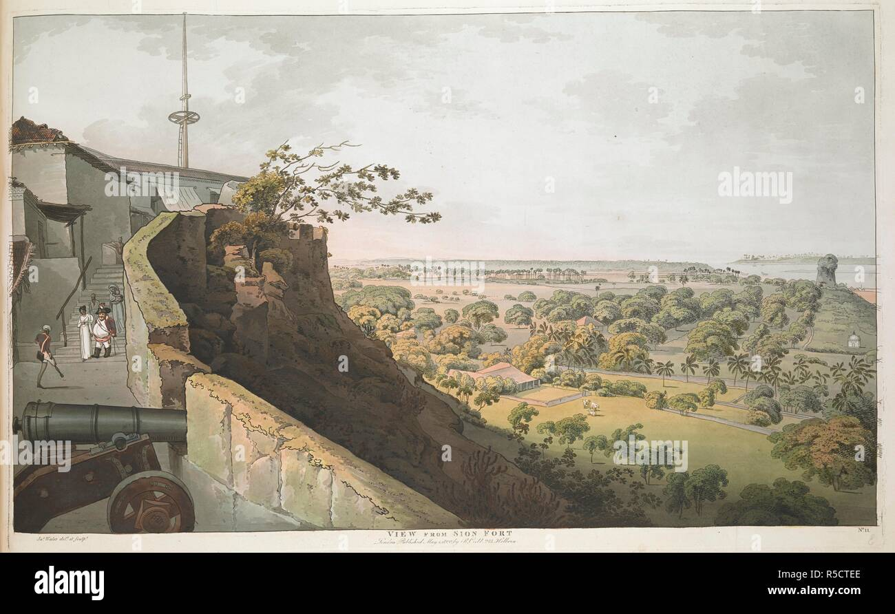
View from Sion fort. Some figures within the fort walls, one amputee can be seen. A view across tress and houses towards the sea. [Bombay Views. Twelve Views of the Island of Bombay and its Vicinity : taken in the years 1791 and 1792] : [designed and engraved on the spot by James Wales ; and brought to this country by Sir Charles Warre Malet]. [London] : [Published by R. Cribb], [1800]. Source: Maps 7 TAB.20. no.11.
View from Sion Fort
From the vantage of Sion Fort, the view opens out to the island of Mahim. In this scene the walls of the fort dominate the foreground, with the curving line of the ramparts and an imposing cannon mounted in the battlement wall. The rising staircase and buildings behind the gun carriage are surmounted by a flagstaff asserting British sovereignty over the island.The figures descending the stairs provide an ironic yet humorous counterpoint to the scene. There is the stout portly figure of an English military official whose waist is bursting from his red uniform, clearly the figure of a buffoon. He is accompanied by a European woman whose hand he holds; behind them follow two figures, one of whom is a woman carrying a small child. The status of these other women is unclear. The companion is clearly a figure of affection, while the woman in blue is presumably a nanny or wetnurse to the child. A one-legged, one-armed sepoy veteran stands waiting to greet the group, thereby highlighting the additional use of the fort as a sepoy hospital or hospice for military veterans. Once again the flat lands below the fort stretch into the indeterminate distance under a wide dominating sky. There are buildings and plantation areas with associated coconut palms in the middle distance, as well as thick clusters of native trees. On the far right of the picture, though significantly trimmed in this version, is a pagoda, or pavilion.
 |
| About LEMA | Find | Projects | Documents | Research | Gallery |
WALES, James (1747-1795)
View from Sion Fort
![[Sion Fort 1]](https://www.mq.edu.au/macquarie-archive/lema/gallery/wales/sionfort1.jpg)
Used with permission from the Peter Anker Collection held in the Kulturhistorisk Museum at the University of Oslo, Norway.
Plate 10: View from Sion Fort, 1791-1792.
James Wales prepared two views of Bombay and its environs from within the walls of Sion Fort. In this first Plate [No. 10] there is a panoramic view over the islands and saltpans of the Bombay archipelago. The view looks down from the Sion Fort gate to Bombay and the Neat's Tongue, bounded by the Mahratta Mountains. James Wales infuses the scene with strong domestic setting, depicting a squatting Indian sepoy (possibly smoking a bhang pipe), with his wife nursing a baby, a small child, dog, and two bullocks (for pulling a two-wheel carriage) in a courtyard outside their modest dwelling beside the fort ramparts. The coastline and horizon are barely distinguishable in the suffused light, though in the middle distance the scene is punctured by the distinctive silhouettes of the coconut palms.
The original Sion Fort was built between 1669 and 1677 by the second British governor of Bombay, Gerard Aungier (c1635-1677), on top of a conical hillock, and it marked the northeast boundary between the British-held Parel Island and Portuguese-held Salsette Island.
Macquarie Connection
Lachlan Macquarie recorded in his journal on 5 October 1789 that he had visited Sion:
I went upon a very pleasant Party today, along with Col. and Mrs. Stirling, and Mr. and Mrs. Herring, and a number of Gentlemen, to Meham, [sic] and Sion Fort, where we dined and spent a very agreeable day; From the Fort on Sion Hill, which commands a most extensive view, we had a most charming Prospect of every part of the Island of Bombay, the neighbouring Islands, and Continent, which along with the variety of breaks of water intervening, forms a most beautiful and very Picturesque Scene; Sion Fort is Nine Measured Miles from Bombay Fort and is one of the Extremities of the Island, – being divided only by a very narrow channel from the large Island of Salcet, [sic] belonging also to the Presidency of Bombay. —
I travelled to Sion in a Palanquin, having Eight Bearers – a very easy and comfortable mode of Travelling in this Country. — We all returned in the Evening to Bombay. —"
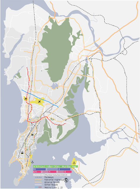
As this map recreated from an old 17th-18th century map[1] of north Bombay island indicates, Sion Fort was located at the tip of the Bombay island, close to the Sion Causeway. The Sion Fort was constructed in 1669/77 by the Governor of Bombay, General Gerald Aungier and it commanded the passage from Bombay to the neighbouring island of Salsette. The fort was of great importance to the British because Salsette was under the control of the Marathas[2]
Today, the gap between Salsette island and the island of Bombay is no more
– with mangroves of Mahim creek on one end and the mangroves of Mankhurd on the other end being the only sign of the old water body. The causeway has been taken over by the Eastern Express Highway. Sion fort is now located in a garden just off the highway, in a lane near the junction of the highway and the Sion Bandra link road leading to Sion Station.
.............................................................................................................................................................

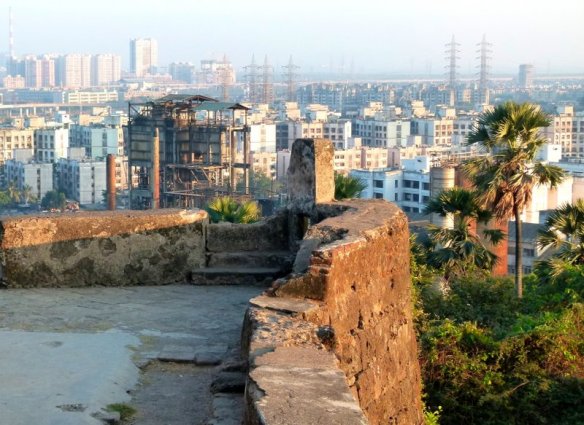
The present view from the fort
-------------------------------------------------------------------------------------------------------------------------
The fort itself is in quite a ruined state. There are steps leading up to the structure at the top. These steps can also be seen in James Wales picture above.
sole remaining cannon in the fort
only walls remaining with doors
steps to go down to the road

The Sion Fort has been restored,15 years back ;Except in patches, most of the original features of the Fort appear to have been lost: for example, a cannon and a portion of the rampart are clearly original, some parts look suspect, while most parts are clearly new.
Sion Hillock Fort


The Sion Hillock Fort is a fort in Mumbai (Bombay), India. It was built under the regime of the English East India Company, between 1669 and 1677, atop a conical hillock when Gerard Aungier was the Governor of Bombay. It was notified in 1925 as a Grade I Heritage structure.[1] When it was built, the fort marked the boundary between British-held Parel island and the Portuguese held Salsette Island that lay to the north across the creek.[2]
The hillock is situated 500 metres from the Sion railway station.[3] At the base of the hill is the Mumbai Circle office of the Archaeological Survey of India,[4] and a garden – the Pandit Jawaharlal Nehru Udyan. Nearby forts include the Riwa Fort and Sewri Fort.
The fort is dilapidated and a collection of broken stone steps, scattered walls and ruins, overrun by trees and ground cover. The fort wall has a small room on top. A series of pathways lead to it. The fort offers a panoramic view, overlooking the salt pans in the Thane Creek. However vandalism and apathy have taken their toll on the structure. Restoration of the fort had begun in 2009 but was stopped mid-way due to paucity of funds.[2]


