

Plate one from J M Gonsalves' "Views at Bombay". Mazagon hill was an outlying suburb of Bombay and became a fashionable place to live in the 18th century. Bungalows and plantation houses were built by the British and more affluent Indians moving out of the crowded fort area. During the 19th century, Mazagon experienced a decline as residents moved into the fashionable Bycullah area nearby. The docks were reclaimed towards the end of the century and Mazagon was left landlocked; eventually the fumes from the developing mills drove out any remaining affluent residents.

View Of Bombay, From Mazagon Hill.and other views of Bombay -18th ,19th century


Mezzotint with etching of a view of Bombay by Elisha Kirkall dated c.1735 after the painting by George Lambert (1710-65) and Samuel Scott (1701/2-72). Inscribed on the front is: 'To the Honourable the Court of Directors of the United-Company of Merchants of England trading to the East-Indies this view of Bombay done after the Painting in the Court Room of the Company house in Leaden Hall Street is most humbly Dedicated by their Honours most obliged and most devoted Servant John Bowles.'
The area of Bombay was composed of seven islands separated by a marshy swamp and inhabited by Koli fisherman. Its deep natural harbour led the Portuguese settlers of the 16th century to name the settlement Bom Bahia 'the Good Bay'. The British Crown acquired the islands as part of the marriage dowry of Catherine of Braganza when she married Charles II in 1661. Bombay was then presented to the East India Company in 1668. The East India Company’s navy was founded at the beginning of the 18th century to protect shipping against pirates and the maritime Mahratta states. Ships were built both locally and in Britain and eventually the fleet was sufficiently powerful to be able to go into action anywhere between the Red Sea and China. The second governor of Bombay, Gerald Aungier offered inducements for skilled workers and traders to settle here and the town quickly developed into a thriving trading port and commercial centre


Plate twenty-one from the first volume of James Forbes'"Oriental Memoirs". Forbes(1749-1819)had arrived in Bombay in 1766 and spent eighteen years of his working-life in this region. 'This view contains the general face of the town towards the harbour; commencing with the Dock-yard, and including the Admiralty, Marine-House, English Church, Pier, Bunder, Castle, Dungaree Fort, or Fort George, and other conspicuous buildings, taken from the shipping opposite Bunder Pier.'
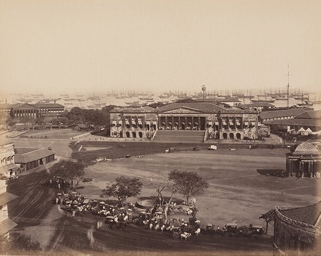
[Bombay Harbour] Docks 1870
 Photograph of ships in the harbour at Bombay from the 'Lee-Warner Collection: 'Bombay Presidency. William Lee Warner C.S.' taken by an unknown photographer in the 1870s. Originally Bombay was composed of seven islands separated by a marshy swamp. Its deep natural harbour led the Portuguese settlers of the 16th century to name it Bom Bahia 'the Good Bay'. In 1661, Bombay was ceded to England as part of the marriage dowry of Catherine of Braganza and was transferred to the East India Company in 1668. Spices and finely woven cloth were two of the main exports that helped Bombay to develop into an internationally significant port. Today, Bombay is one of India's major industrial centres and the capital of Maharashtra.
Water-colour painting of Mumbai Harbour by Nicholas Chevalier (1828-1902) in January 1870. Inscribed on the back in pencil is: 'Bombay.'
Originally, Mumbai (Bombay) was composed of seven islands separated by a marshy swamp. Its deep natural harbour led the Portuguese settlers of the 16th century to call it Bom Bahia (the Good Bay). The British Crown acquired the islands in 1661 when Catherine of Braganza married Charles II, as part of her marriage dowry. It was then presented to the East India Company in 1668. The second governor, Gerald Aungier, developed Bombay into a trading port and centre for commerce and inducements were offered to skilled workers and traders to move here. European merchants and shipbuilders from western India were encouraged to settle here and Mumbai soon became a bustling cosmopolitan town.


Coloured lithograph of a view in Bassein Fort by Rudolph Ackermann (1764-1834) after Captain James Barton (1793-1829) plate 7 of Barton's 12 Views of Hill Forts in the Western Ghats near Bombay published in London c.1820. Bassein (Vasai) is situated at the mouth of the Ulhas River north of Bombay. In 1534, the Portuguese seized Bassein from Bahadur Shah, the Sultan of Gujarat, and the town remained in their control for just over 200 years. At the height of its prosperity, Bassein had 5 convents and 13 churches. In 1739, Bassein was taken by the Marathas. In 1802, the British secured the Treaty of Bassein with Peshwa Baji Rao II, which allowed British forces to be stationed in Maratha territory.
Click on image for details.

his is plate 10 from Robert Melville Grindlay's 'Scenery, Costumes and Architecture chiefly on the Western Side of India'. Grindlay (1786-1877) was only 17 when he arrived in India in 1803. He served with the Bombay Native Infantry from 1804 to 1820 and during this period made a large collection of sketches and drawings.
The Bhor (or Bhore) Ghat is the northern part of today's Maharashtra state and is the main pass over the Western Ghats and the primary means of communication between the coast and the Deccan. Bhor was a native state of India in the Poona Political Agency, situated among the highest peaks of the Western Ghats. Grindlay quotes Lord Valentia's description of the Ghat: "Towards day I came to a turn in the road, where an opening showed me the lofty mountains I had been descending, covered with forests to nearly their summits. We had passed several rivulets; here they had joined and formed a small stream. I was now able to perceive the rich vegetation around me ... the most conspicuous was the dracontium pertusum, which perfectly covered the gigantic stem of the ficus Bengalensis with its leaves.

This is plate 9 from Robert Melville Grindlay's
'Scenery, Costumes and Architecture chiefly on the Western Side of
India'. Grindlay (1786-1877) was only 17 when he arrived in India in
1803. He served with the Bombay Native Infantry from 1804 to 1820 and
during this period made a large collection of sketches and drawings.
The Bhor (or Bhore) Ghat is the northern part of today's Maharashtra state. It is the main pass over the Western Ghats and the primary means of communication between the coast and the Deccan. Bhor was a native state of India in the Poona Political Agency, situated among the highest peaks of the Western Ghats. Grindlay quotes Lord Valentia to describe the difficulties of travelling here: "The road has been formed ... out of a bed of loose rock, over which the torrents in winter had run with such force as to wash away all the softer parts ... to get the palanquin over these was a tedious and difficult business ... the boys were obliged to use sticks ... to prevent themselves being thrown forward ... though I walked the whole way, not only to relieve them, but to admire the sublimity of the scenery."
The Bhor (or Bhore) Ghat is the northern part of today's Maharashtra state. It is the main pass over the Western Ghats and the primary means of communication between the coast and the Deccan. Bhor was a native state of India in the Poona Political Agency, situated among the highest peaks of the Western Ghats. Grindlay quotes Lord Valentia to describe the difficulties of travelling here: "The road has been formed ... out of a bed of loose rock, over which the torrents in winter had run with such force as to wash away all the softer parts ... to get the palanquin over these was a tedious and difficult business ... the boys were obliged to use sticks ... to prevent themselves being thrown forward ... though I walked the whole way, not only to relieve them, but to admire the sublimity of the scenery."

This is plate 12 from James Wales' 'Bombay Views'. The series was painted for Sir Charles Malet (1752-1815), the British Resident of Poona, who met Wales in Bombay in 1791.
Wales wrote that this image was: "Taken from the Landing-Place of this celebrated Island, exhibiting the colossal statue of the Elephant whence it is named, including the little island of Butcher on the right." The rock-cut temples dating to some 6th century AD on this island are dedicated to the Hindu deity Shiva in the form of Mahadeva.


This is plate 3 from James Wales' 'Bombay Views'. The series was painted for Sir Charles Malet (1752-1815), the British Resident of Poona, who Wales met in Bombay in 1791.
The panoramic view (continued on plate 4) was taken across the Back Bay and includes the Flag Staff at Malabar Point, part of Old Woman's Island, the light house, Mendham's Point and Bombay. The islands of Karanja and Elephanta are pictured in the distance, with the Mahratta Mountains in the background. In 1782, the British were forced by the Treaty of Salbai to cede all the land they had won to the Marathas, in exchange for the Salsette, Elephanta, Karanja and Hog islands.


This is plate 9 from James Wales' 'Bombay Views'. The series was painted for Sir Charles Malet (1752-1815), the British Resident of Poona, who Wales met in Bombay in 1791.
The view represents that "part of the Island between the Hill of Belmont and the Breach Water, Malabar Hill to the left, the Breach or Causeway in front, and the country extending from Love Grove toward Mahim on the right terminating the scene". The Great Breach, or Hornby Vellard, appears in the foreground. Begun in 1782 by William Hornby, Bombay's governor, it was one of the first major engineering projects implemented to transform the seven islands of Bombay into one landmass. It was constructed to prevent the low-lying areas of Bombay from being flooded at high tide.
There is a romantic Muslim legend attached to Love Grove, on the right of the view, concerning two drowned lovers, today commemorated in Hadji Ali's mosque.


This is plate 8 from James Wales' 'Bombay Views'. The series was painted for Sir Charles Malet (1752-1815), the British Resident of Poona, who Wales met in Bombay in 1791.
The view shows the islands of Bombay, part of the village of Mazagaon, and the Mahratta mountains in the background. The top of Belvidere House and Cross Island are on the left; to the right is Fort George. Ships are pictured at anchor in the harbour. Across the water is Chaul and the Kanheri
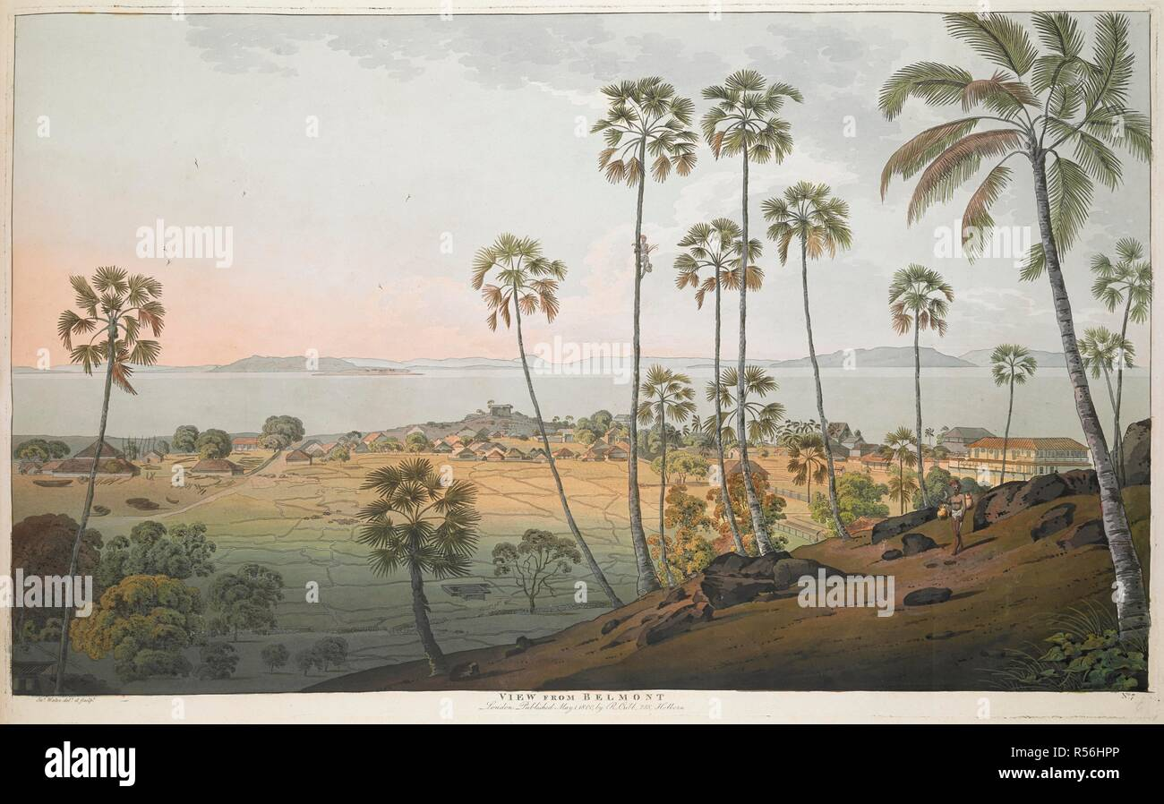

This is plate 7 from James Wales' 'Bombay Views'. The series was painted for Sir Charles Malet (1752-1815), the British Resident of Poona, who Wales met in Bombay in 1791. The view shows "Belmont toward the beach of the Harbour, including part of the village of Mazagon, the island of Carranjar, Elephanta and Butcher, bounded by the hills". Mazagaon was an outlying suburb of Bombay and a fashionable place to live in the late 18th century. Moving out of the crowded fort area, the British - and more affluent Indians such as the Wadias - built bungalows and plantation houses here .