Yakut Khan
His real name was Siddi Qasim Khan| Murud Janjira | |
|---|---|
| Raigad district, Maharashtra | |
 Murud Janjiraa bastions |
who first served under Bijapur Sultanate
| Bijapur Sultanate बिजापूर सल्तनत् ಬಿಜಾಪುರ ಸಲ್ತನತ್ | ||||
| ||||
 | ||||
| Capital | Bijapur | |||
| Language(s) | Deccani Urdu | |||
| Religion | Shi'a Islam | |||
| Government | Monarchy | |||
| Shah | ||||
| - 1490–1510 | Yusuf Adil Shah | |||
| - 1510–1534 | Ismail Adil Shah | |||
| - 1534 | Mallu Adil Shah | |||
| - 1534–1558 | Ibrahim Adil Shah I | |||
| - 1558–1580 | Ali Adil Shah I | |||
| - 1580–1627 | Ibrahim Adil Shah II | |||
| Historical era | Late Medieval | |||
| - Established | 1527 | |||
| - Disestablished | 1686 | |||
and later under the Mughal Empire. His real name was Siddi Qasim Khan but was given the title of Yakut Khan by Emperor Alamgir. During a Muhgal-English conflict he laid siege to the British-held Bombay in 1689.
The Siddis are a community of African ancestry that live in much of Karnataka and Kerala, India. They were loyal to the Mughals and had earned a reputation as excellent sea-farers.
In October, 1672, Khan entered the seven islands of Bombay

and attacked the Marathas with whom they were at war with. Khan returned the following year, on 10 October 1673, after destroying the towns of Pen and Nagothane.
Yakut Khan, along with Khariyat Khan, had earlier saved the Portuguese from the Marathas left by Sambhaji

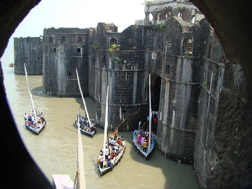
The Sidis' never-conquered island fort of *Murud-Janjira* (1500's on), in Raigarh district, Maharashtra
Source: http://www.flickr.com/photos/roving_eye/840023794/
(downloaded Dec. 2008)

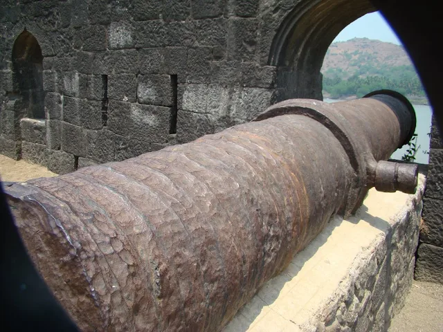
A view from the highest point of the fort
Source: http://www.indiamike.com/photopost/showphoto.php/photo/25776/l
(downloaded Dec. 2008)

Another overview of the fort
Source: http://www.flickr.com/photos/sunilkashikar/2517703610/
(downloaded Dec. 2008)

Stone against water
Source: http://www.flickr.com/photos/himanshu_sarpotdar/2046220363/
(downloaded Dec. 2008)

An interior view
Source: http://www.indiamike.com/photopost/showphoto.php/photo/25773/
(downloaded Dec. 2008)
| Sambhaji Bhosale | |
|---|---|
 | |
| Born | May 14, 1657 |
In return, they enjoyed a cordial relationship in the otherwise tense political climate.
In 1689, the Mughal Emperor Aurangzeb
| Abul Muzaffar Muhy-ud-Din Muhammad Aurangzeb Alamgir | |
|---|---|
 | |
ordered the Khan to attack Bombay for the third time after Indian vessels sailing to Surat
In 1689, the strong Mughal fleet from Janjira commanded by the Sidi Yaqub and manned by Mappila from Ethiopian Empire[mappila is from kerala for the information.also Ethiopians are neither mappilas nor they took part in Indian war; but slaves of arabs ] [besieged the British fort of Bombay.[8]
After a year of resistance, a famine broke out which caused hundreds of
deaths, the British surrendered, and in 1690 the company sent envoys to
Aurangzeb's court to plea for a pardon and to renew the trade firman.
The company's envoys had to prostrate themselves before the emperor, pay
a large imperial fine of 1,50,000 rupees, and promise better behavior
in the future. Emperor Aurangzeb then ordered Sidi Yaqub to lift the Siege of Bombay and the company subsequently re-established itself in Bombay and set up a new base in Calcutta.[6]
..............................................................................................
The 1689 Siege of Bombay in Global Historical Perspective
Philip J. Stern
On February 15, 1689, the East India Company’s fort, settlement, and town at Bombay (today, Mumbai) received an unwelcome surprise. Along with a large retinue of sailors and soldiers, Sidi Qasim Yaqut Khan, a tributary naval com-mander for the Mughal Empire and a power in his own right in the western Indian littoral, landed at the village of Sewri to the north of Bombay fort, and proceeded to occupy and force evacuation of the outlying fortlets around the archipelago – at Sewri, as well as Mahim, Sion, and Worli. Ultimately making his way to the southeastern hill forts at Mazagaon and Dongri, for the next sixteen months, his forces laid siege to the fort and town of Bombay, which only two years earlier the East India Company had effectively declared the capital of its operations throughout Asia.1
 Old Fort of Surat | The Ancient ...
Anglo-Mughal War - Wikipedia
en.wikipedia.org › wiki › Anglo-Mughal_War
In 1689, the strong Mughal fleet from Janjira commanded by the Sidi Yaqub and manned by Mappila from Ethiopian Empire besieged the British fort of Bombay.
..............................................................................................
The 1689 Siege of Bombay in Global Historical ... - Brill
brill.com › previewpdf › book › edcoll
retinue of sailors and soldiers, Sidi Qasim Yaqut Khan, a tributary naval com- ... J. Stern, eds., The English East India Company at the Height of Mughal Expansion: A ... self as both a commercial and political power in the western Indian littoral, ... case of the ways in which military defeat leads to reassessment and transforma-.
The 1689 Siege of Bombay in Global Historical Perspective
Philip J. Stern
On February 15, 1689, the East India Company’s fort, settlement, and town at Bombay (today, Mumbai) received an unwelcome surprise. Along with a large retinue of sailors and soldiers, Sidi Qasim Yaqut Khan, a tributary naval com-mander for the Mughal Empire and a power in his own right in the western Indian littoral, landed at the village of Sewri to the north of Bombay fort, and proceeded to occupy and force evacuation of the outlying fortlets around the archipelago – at Sewri, as well as Mahim, Sion, and Worli. Ultimately making his way to the southeastern hill forts at Mazagaon and Dongri, for the next sixteen months, his forces laid siege to the fort and town of Bombay, which only two years earlier the East India Company had effectively declared the capital of its operations throughout Asia.1

surat360.com
were captured in 1686. In April 1689, the Siddis laid siege to the British fortification

to the south. The British governor Sir John Child appealed to Aurangzeb. In February 1690, the Mughals agreed to halt the attack in return for 150,000 rupees (Over a billion USD at 2008 conversion rates) and Child's dismissal. Child's untimely death in 1690 however, resulted in him escaping the ignominy of being sacked.
Enraged at the agreement, Sakat withdrew his forces on 8 June 1690 after razing the Mazagaon Fort.
Relations between the British and the Siddis of Janjira had never been very cordial, so when the war in Bengal began, the East India Company’s Governor at Bombay, Sir John Child, indulged in war mongering aimed at the Siddis. Although they had nominal control of Bombay, he wanted to make it total by eliminating any competition.
Aurangzeb versus the East India Company - DNA India
www.dnaindia.com › Analysis
Sep 9, 2018 — The Battle of Plassey was three generations away. ... In January 1686, six companies of British soldiers landed at Hughli after mistaking the route to Chittagong. ... Bengal began, the East India Company's Governor at Bombay, Sir John Child, ... This was around 1689-1690. ... Views expressed are personal.
Child then went ahead and captured a few trading ships belonging to Siddi Kasim. The result was as it was anticipated: A blockade of Bombay. This was around 1689-1690. Siddi Kasim captured the island of Mazgaon and placed his cannons on the hills of Dongri. He further proceeded to bomb the British garrisons. If he had continued for a few months more, he would have captured Bombay.
Few people know that it was a Parsi, Rustomji Dorabji, who prevented Mumbai from going under the control of Siddi of Janjira. He brought together a motley but spirited crowd of Kolis and Bhandaris to defend the islands.
Eventually, supplies ran out for Sir John Child, and he was forced to raise the white flag and plead for a pardon. According to some accounts, British officials in Surat were paraded in chains on the streets of Surat, while some went to Aurangzeb with their hands tied behind their backs seeking mercy. Sir John Child offered to pay the Mughal a total of Rs 1.50 lakh as fine. His apologies were accepted, as were those of British officials in Bengal, Surat and Fort St. George. In 1698, the same Aurangzeb allowed the East India Company to construct Fort William in Bengal. Trade was to continue as before
Khan died in 1733.

Shivaji
On his escape from Delhi at the close of 1666, Shivaji drove the Moghals out of most of the south-east of Thana. They continued to hold the great hill-forts of Karnala

and Mahuli,

but, after heavy fighting, lost them also in 1670.
In 1670 the Portuguese defeated Shivaji at sea
But he came perilously near them on land, taking several forts in the north-east of Thana and attacking Ghodbandar

in Salsette.

This advance of Shivaji's led the English to send him an envoy, and an alliance was agreed to, in which he promised to respect the English possessions.
In 1672 the Sidi of Janjira, whose appointment as Moghal admiral had lately (1662) increased his importance, blockaded the Karanja river

and made a fort at its mouth. In October of the same year (1672) a Sidi and Moghal squadron landed troops on the banks of the Nagothna river, laid the country waste, and carried off the people as slaves
In February 1673 a Dutch fleet,

under their Governor General, appeared before Bombay and caused such alarm that the settlers fled to the Portuguese territories. But the Governor, Gorald Aungier, had given so much care to the fortifications

and to strengthening the garrison and organizing the militia that, after hovering about the mouth of the harbour for some time, the Dutch retired without attempting an attack
Another cause of difficulty in Bombay were the Sidis. Nearly every season between 1672 and 1680, sometimes with leave sometimes without leave, the Sidis came to Bombay to winter, that is to pass the stormy south-west monsoon (May-October). In 1674 they scared the people from Sion fort in the north-east of the Island, but were attacked by English troops, and an agreement was made that not more than 300 of the Sidi's men were to remain on shore at one time and that none of them wore to have any arms except a sword. These visits placed the English in an unpleasant dilemma. If they allowed the Sidis to land, they roused the suspicion and anger of Shivaji; if they forbad the Sidis landing they displeased the Moghals
 |
| RAJAPUR FACTORY |
 |
| DHABOL FORT |
 |
| Pen and ink drawing of Sewri Fort in Bombay looking across to Trombay Island by William Miller (1795-1836) in 1828 In April 1674 Shivaji was crowned at Raygad fort near the town of Mahad in south Kolaba. An embassy sent by the Bombay Government found him friendly. He granted them leave to trade to any part of his territory on paying an import duty of two and a half per cent; he allowed them to establish factories at Rajapur and Dabhol in Ratnagiri, Weavers came from Chaul to Bombay, and a street was ordered to be built for them stretching from the customs-house to the fort.  |
The view shows the islands of Bombay, part of the village of Mazagaon, and the Mahratta mountains in the background. The top of Belvidere House and Cross Island are on the left; to the right is Fort George. Ships are pictured at anchor in the harbour. Across the water is Chaul and the Kanheri.

Marine Battalion, Esplanade.-BOMBAY-Artist: Gonsalves, Jose M. (fl. 1826-c.1842) Medium: Lithograph Date: 1826

Lithograph of the Marine Battalion at the Esplanade by Jose M. Gonsalves (fl. 1826-c.1842). Plate 4 from his 'Lithographic Views of Bombay' published in Bombay in 1826. Gonsalves, thought to be of Goan origin, was one of the first artists to practice lithography in Bombay and specialised in topographical views of the city. In 1772, the English feared an attack on Bombay by the French and cleared a semi-circular area of land around the fort to provide a clear line of fire. This area was known as the Esplanade. In the southern section of this area, there was a parade ground known as Marine Lines. This view shows a battalion soldiers on parade with military bungalows in the background.
BOMBAY-Back Bay in 1861.-Photographer: Johnson, William Medium: Photographic print Date: 1861

Photograph taken by William Johnson in 1861, of Back Bay in Bombay (Mumbai), Maharashtra, from an album of 40 albumen prints taken in the 1860s. The busy port and industrial hub of Bombay is the capital of Maharashtra. During British rule, it was the administrative capital of the Bombay Presidency. Extending over a peninsula into the Arabian Sea on the west coast of India, Bombay prospered with maritime trade and became the chief commercial centre of the Arabian Sea. Originally a collection of fishing villages of the Koli community built on seven islands, Bombay was by the 14th century controlled by the Gujarat Sultanate who ceded it to the Portuguese in the 16th century. In 1661 it was part of the dowry brought to Charles II of England when he married the Portuguese princess Catherine of Braganza. In the 19th century, Bombay burgeoned with economic activity and grew huge. Land reclamation along Back Bay provided for further development. Back Bay is located at the southeast tip of Bombay, near the fort and central district. In this view local craft are beached in the foreground.
Elphinstone Circle, Bombay-Photographer: Unknown Medium: Photographic print Date: 1860

This photograph was taken by Samuel Bourne in the 1860s. Elphinstone Circle was constructed from about 1860 onwards on the site of Bombay Green in the centre of the Fort area. It lies at the eastern end of Vir Nariman Road, formerly known as Church Gate Street. The elegantly curved, arcaded terraces exhibit unified Italian facades enriched with cast-ironwork imported from England. Following Independence the area was renamed after Benjamin Horniman, an English journalist who was an ardent proponent of Indian self-determination.
Y
'Pagoda and church in Fort of Bassein, 1828'. Lithograph hand-coloured by W. Miller.

Lithographer: Miller, William (1795-1836)
Medium: Lithograph, coloured
Date: 1828
Coloured lithograph of a church and temple in Bassein Fort by William Miller (1795-1836) in 1828. Bassein (Vasai) is situated at the mouth of the Ulhas River north of Bombay. In 1534, the Portuguese seized Bassein from Bahadur Shah, the Sultan of Gujarat, and the town remained in their control for just over 200 years. At the height of its prosperity, Bassein had 5 convents and 13 churches. In 1739, Bassein was taken by the Marathas. In 1802, the British secured the Treaty of Bassein with Peshwa Baji Rao II, which allowed British forces to be stationed in Maratha territory.

Aquatinter: Clark, J. (fl.1789-1834)
Medium: Aquatint, coloured
Date: 1813
Coloured aquatint of the Fleet under Convoy of H. M.'s Ship 'Chiffone' Captain Wainwright leaving Bombay in Maharashtra by J. Clark (fl.1789-1834) after an original drawing of September 14th 1809 by Robert Temple (fl.early 1800) of the H. M. 65th Regiment and published in London in 1813.
In 1674, Bombay replaced Surat as the headquarters of the English East Company in India. The esplanade, seen in the foreground of this view, provided a clear range of fire from the fort and was added in the 1770s to protect the city from the French.
Sailors' Home [Bombay].--Photographer: Unknown Medium: Photographic print Date: 1870
![Sailors' Home [Bombay].](https://lh3.googleusercontent.com/blogger_img_proxy/AEn0k_vOLMiEaBqcfOT6e8er0t_3IyCIkhQ4CuSs12qC6C7sEdjgQeTHUB8LTiX2f15ygyBZzuZvgjokABgiLFslsyxN4OsNmPu1t2MW3EDdxeOUjQ4gM9h-DMD62pwKKu7v1xdCXkbbT2c=s0-d)
Photograph of the Sailor's Home buildingl, taken by an unknown photographer in the 1870s in Bombay (Mumbai), Maharashtra, from an album of 40 prints mostly dating from the 1860s. Bombay, the capital of Maharashtra and one of India's major industrial centres and a busy port, was originally the site of seven islands on the west coast, sparsely populated by Koli fisherfolk. Bombay was by the 14th century controlled by the Gujarat Sultanate who ceded it to the Portuguese in the 16th century. In 1661 it passed to the English as part of the dowry brought to Charles II by the Portuguese princess Catherine of Braganza. By the 19th century Bombay was a prosperous centre for commerce. The removal of the ramparts of the fort had opened up the city to fresh developments in architecture, and in the second half of the 19th century Bombay witnessed accelerated building activity fuelled by its booming maritime trade. A collection of grand public buildings sprang up at the Esplanade and city centre. The Royal Alfred Sailors' Home was completed in 1876 and is now the Bombay Council Hall. The building was designed by the architect Frederick William Stevens, an engineer with the Indian Public Works Department.
Town & Fort of Dejouri,=Artist: Nash, Alexander (fl. 1834-1846) Medium: Pencil on paper Date: 1844

Pencil drawing of the town and fort of Dejouri (Deogiri or Daulatabad) by Alexander Nash (fl. 1834-1846) between 1844 and 1845. This image is from an album of 19 drawings (19 folios) depicting the monuments of Bijapur and the hill forts of Dejouri and Purandhar, made during a Revenue Survey of the Deccan. Nash served with the Bombay Engineers and from 1836 was mainly employed in the Revenue Survey of the Deccan, first as an assistant and from 1841 as Superintendent.
The citadel of Devagiri, "Hills of Gods" was occupied and renamed Daulatabad "City of Fortune" after the Tughluq conquest at the end of the 13th century. In the 14th and 15th centuries it became the capital of the Bahmani sultans of the Deccan and was taken by the Mughals in 1633. The impressive fortress is situated on the top of a steep hill 200 metres high. There are three concentric lines of fortifications between the outer wall and the citadel which is reached by steep flights of steps. The remains of the original town of Deogiri are enclosed by the outer walls, entered through three gateways. A series of underground passages carved into the solid rock lead to the citadel.
Church Gate Street, Bombay.Photographer: Unknown Medium: Photographic print Date: 1860

CHURCH GATE =THE GATE OF THE BOMBAY FORT ; NEAR TO ST THOMAS CATHEDRAL CHURCH,SEEN AT FAR END [THE FORT HAD MANY SIMILAR GATES ;The fort walls had three main gates. One was the Apollo Gate, near the present day location of the St. Andrew's Church. The most well-known was Church Gate, named after St. Thomas', standing almost exactly on the spot that the Flora Fountain now occupies. The third was the Bazaar Gate, right opposite the present dome of the General Post Office, which lends its name to the area even now, long after the gate itself has disappeared.]
This view of Churchgate Street, now known as Vir Nariman Road, in the Fort area of Bombay was taken in the 1860s to form part of an album entitled 'Photographs of India and Overland Route'. Churchgate Street runs from Horniman Circle at the east end to what was originally named Marine Drive at the edge of the Back Bay. Churchgate Station, the old General Post Office (now the Telegraph Office) and the Cathedral Church of St Thomas, the oldest still-functioning structure in the city, are all located along its length. However, Churchgate Station and the Post Office were later additions to the street and would not have been in existence at the time of this photograph.
In 1772 an order was promulgated to segregate Indian and English houses, both within and outside the Fort. A more important development came five years later, in 1777, when the first newspaper in Bombay was published
'View of Bombay Harbour, taken from the Island of Colaba'. Uncoloured lithograph by W. Watson from C. Head's Eastern and Egyptian Scenery London, 1833. Printed by C. Hullmandel.

Lithograph of Bombay harbour by W. Watson after Charles Franklin Head from his 'Eastern and Egyptian Scenery' printed by C.Hullmandel and published in London in 1833. The area of Bombay was originally composed of seven islands separated by a marshy swamp. In 1661, the British Crown acquired the islands of Bombay from the Portuguese as part of Catherine of Braganza's marriage dowry to Charles II. From 1668, the East India Company developed the area as a trading port. The fort was situated on the island of Bombay. The island of Colaba, to the south, became a popular place for recreation in the 18th century and was connected to the island of Bombay by a causeway the 1830s.
Back Bay, Bombay.--Photographer: Johnson and Henderson Medium: Photographic print Date: 1855

A photograph of the Back Bay in Bombay from the 'Vibart Collection of Views in South India' taken by Johnson & Henderson about 1855. Originally, Bombay was composed of seven islands separated by a marshy swamp. It’s deep natural harbour led the Portuguese settlers of the 16th Century to call it Bom Bahia (the Good Bay). The British Crown acquired the islands in 1661when Catherine of Braganza married Charles II, as part of her marriage dowry. It was then presented to the East India Company in 1668. The second governor, Gerald Aungier, developed Bombay into a trading port and centre for commerce and inducements were offered to skilled workers and traders to move here. Back Bay is located on the southeast tip of the island near the fort, the central business district and the area known as Colaba.The Back Bay Reclamation Project was originally proposed in 1865, started in 1913, sidelined by government regulations until 1922, abandoned in 1930, proposed again in 1950 and finally completed in 1970.
Elphinstone Circle, Bombay.

Photograph of Elphinstone Circle in Bombay from the 'Lee-Warner Collection: 'Bombay Presidency. William Lee Warner C.S.' taken by an unknown photographer in the 1870s. Elphinstone Circle was laid out in 1869 on the site of the old Bombay Green in Fort area of the city. The buildings were designed by James Scott as part of the redevelopment of Bombay which began under the Governorship of Sir Bartle Frere in the 1860s. This view shows that these buildings are characterised by the uniformity of their design and the use of a covered arcade at ground level. Following Independence, the Circle was renamed Horniman Circle. This name refers to Benjamin Horniman, an English journalist.
The Secretariat [Bombay].--Photographer: Unknown Medium: Photographic print Date: 1870
![The Secretariat [Bombay].](https://lh3.googleusercontent.com/blogger_img_proxy/AEn0k_tHogZCKb4EsEzjxHsIu306SyRlspiVLnntQahkaO2dTQvtEDu4UY6gRItx6WZC9QbahqsgX2D4QBBaxv6qOrI6ibF0HgqKOXb9v2lefU5W8coG3De_irXw6bpIM9uLJeRxedmfE2U=s0-d)
Photograph of the Secretariat building, taken by an unknown photographer in the 1870s in Bombay (Mumbai), Maharashtra, from an album of 40 prints mostly dating from the 1860s. Bombay, the capital of Maharashtra and one of India's major industrial centres and a busy port, was originally the site of seven islands on the west coast, sparsely populated by Koli fisherfolk. Bombay was by the 14th century controlled by the Gujarat Sultanate who ceded it to the Portuguese in the 16th century. In 1661 it passed to the English as part of the dowry brought to Charles II by the Portuguese princess Catherine of Braganza. By the 19th century Bombay was a prosperous centre for commerce. The removal of the ramparts of the fort had opened up the city to fresh developments in architecture, and in the second half of the 19th century Bombay witnessed accelerated building activity fuelled by its booming maritime trade. A collection of grand public buildings sprang up at the Esplanade and city centre. The Bombay Secretariat was completed in 1874 and designed by Captain Henry St. Clair Wilkins in the Venetian Gothic style. With its arcaded verandahs and huge gable over the west facade, it was a monument to the civic pride of Bombay's British rulers.

Thana Fort on the Island of Salsette seen from the Esplanade. Camels and European figures in the foreground Artist: Heen, A. van der (fl. 1782) Medium: Wash Date: 1752

Wash drawing by A. van der Heen (fl. 1782) of Thana Fort on the Island of Salsette near Bombay in Maharashtra, seen from the Esplanade, with camels and European figures in the foreground, dated 1782. The image is inscribed on the back in ink: 'Tanah fort taken from the Esplanade. A. van der Heen fecit, 1782.'
Thana Fort on the Island of Salsette seen from the mainland. European figures in the foreground Artist: Heen, A. van der (fl. 1782) Medium: Watercolour Date: 1782

Wash drawing by A. van der Heen (fl. 1782) of Thana Fort on the Island of Salsette, near Bombay in Maharashtra, seen from the mainland with European figures in the foreground, dated 1782. The image is inscribed on the back in ink:' Thanah Fort on the Island of Salsett taken from the Contenent. A. van der Heen delt ad Vivum, 1782.'
Government House, Parell [Parel, Bombay].-Photographer: Unknown Medium: Photographic print Date: 1860
![Government House, Parell [Parel, Bombay].](https://lh3.googleusercontent.com/blogger_img_proxy/AEn0k_sdGjRq-y78uGXw_sN6lFp2bEmOdWKR25EFMam_dtCvbwZaPizHQaRlkdDVBC3J5BsQVM_-xuiepQ3uuwy7RY1sB60xXHltlbg09LfOXR3nBvyaTLcM8024Pfd530cmbNB11QqwSQ=s0-d)
Photograph of Government House at Parel in Bombay (Mumbai), Maharashtra, taken by an unknown photographer, from an album of 40 prints of the 1860s. The busy port and industrial hub of Bombay is the capital of Maharashtra. During British rule, it was the administrative capital of the Bombay Presidency. Extending over a peninsula into the Arabian Sea on the west coast of India, Bombay prospered with maritime trade and became the chief commercial centre of the Arabian Sea. Originally a collection of fishing villages of the Koli community built on seven islands,
Bombay was by the 14th century controlled by the Gujarat Sultanate who ceded it to the Portuguese in the 16th century. In 1661 it passed to the English as part of the dowry brought to Charles II by the Portuguese princess Catherine of Braganza. This building was originally a Portuguese Franciscan friary, completed in 1673 and taken over by Governor Boone in 1719 as a country residence after which it became the official summer home of Governors of Bombay, and Parel developed as an affluent district. In 1771, when William Hornby resided here as Governor, it became the new Government House in place of the original one in the Fort. The banqueting hall and ballroom are housed in the shell of the original vaulted chapel, and were much admired for their splendour. Several mills now sprang up on the newly-reclaimed flats around Parel and the ensuing congestion and pollution resulted in the shifting of the Governor's residence to a new Government House at Malabar Point. After the plague epidemics in the 1890s, the house at Parel was converted into the Haffkine Research Institute.
View Of Bombay, From Mazagon Hill.--Artist: Gonsalves, Jose M. (fl. 1826--c. 1842) Medium: Lithograph, coloured Date: 1833

Mazagon hill was an outlying suburb of Bombay and became a fashionable place to live in the 18th century. Bungalows and plantation houses were built by the British and more affluent Indians moving out of the crowded fort area. During the 19th century, Mazagon experienced a decline as residents moved into the fashionable Bycullah area nearby. The docks were reclaimed towards the end of the century and Mazagon was left landlocked; eventually the fumes from the developing mills drove out any remaining affluent residents.
Hill Fort, Poorandhur--Artist: Nash, Alexander (fl. 1834-1846) Medium: Pencil on paper Date: 1844

Pencil drawing of Purandhar Fort by Alexander Nash (fl. 1834-1846) between 1844 and 1845. This image is from an album of 19 drawings depicting the monuments of Bijapur and the hill forts of Dejouri and Purandhar, made during a Revenue Survey of the Deccan. Nash served with the Bombay Engineers and from 1836 was mainly employed in the Revenue Survey of the Deccan, first as an assistant and from 1841 as Superintendent.
Purandhar Fort is situated on a basalt cliff commanding a passage through the Western Ghats in Maharashtra. There are actually two forts on this site, Purandhar, the stronger of the two and the lower fort of Wazirgarh, or Vajragad. The fortifications are protected by a wall which is 42 km in extent and relived by three gateways and six bastions. The earliest fortifications on this site date from 1350 and there is also a Mahadev temple near to the Delhi Gate of the fort. Later it became one of the most important strongholds of Shivaji, the independent Hindu king of muslim (Mughal) dominated India and was also a retreat for the Peshwars until in 1818 when it fell to the British under General Pritzler.
Town Hall, Bombay--Artist: Medium: Pen and ink on paper Date: 1825
 \
\Pen and ink drawing of the Town Hall in Bombay by an unknown artist c.1825. Bombay, the capital of Maharashtra, is one of India's major industrial centres. The Town Hall is situated on the east side of Elphinstone Circle, formally Bombay Green, in the fort area of Bombay. The Town Hall was designed in the Neo-Classical style by Colonel Cowper of the Bombay Engineers and the construction started before he died in 1825. This drawing may be one of the preparatory works for the final design of the building. The Town Hall was finally completed in 1833 with the assistance of Charles Waddington.
View of Bombay Harbour--Artist: Wales, James (1747-1795) Medium: Etching, coloured Date: 1800

The panoramic view (which continues on plate two) depicts the dockyard and fort areas, including the Pier Head Battery on the left. Chaul, the seaport of Konkan, can be seen on the right, with the island of Karanja on the left. Completed in 1784 under the governorship of William Hornby, the Hornby Vellard was the first major work of reclamation in Bombay. The dockyard itself was initiated by the famous Wadia family, who moved to Bombay from Surat in 1736. Bombay soon began to develop into a major trading town and by the middle of the century workers from the neighbouring towns, including the Bhandaries from Chaul, and goldsmiths, ironsmiths and weavers from Gujarat, migrated to the island.
View of Bombay from Colaba.island-1828

Bombay was originally composed of seven islands. However, since the 18th century, land reclamation projects joining the islands together have dramatically altered its topography. By 1838, the Island of Colaba was connected to Bombay by a causeway that was only accessible at low tide. In this view, we can see the causeway being constructed with the use of timber. Bombay came under English control as part of the dowry brought to Charles II by the Portuguese princess Catherine of Braganza in 1661. The fort area, shown in this view, was located on Bombay Island.
Artist: Gonsalves, Jose M. (fl. 1826-c.1842)
Medium: Lithograph
Date: 1826
Panorama of Bombay from the Ladies' Gymkhana, Malabar Hill.-Photographer: Unknown Medium: Photographic print Date: 1880

Photograph of a panoramic view of Bombay (Mumbai), part of the Earl of Jersey collection taken in the 1880s by an unknown photographer. The capital of Maharastha on the west coast of India, Bombay was originally a group of fishing villages. By the 14th century it was controlled by the Gujarat Sultanate who ceded it to the Portuguese in the 16th century. In 1661 it passed to the English as part of the dowry brought to Charles II by the Portuguese princess Catherine of Braganza. In the 17th century, the British built up fortifications around the original Portuguese settlement of the area overlooking the harbour. In the 1760s the fortifications were enhanced as the British were engaged in war with France in both Europe and India. By the 19th century the British had established control and in 1864 the fort walls were torn down and the area was converted into the central district of Bombay city. The removal of the ramparts of the fort opened up the city to new developments in architecture, and in the second half of the 19th century accelerated building activity was fuelled by its booming maritime trade. This photograph is taken in two parts and looks across Back Bay from the top of Malabar Hill.
Esplanade and Bandstand, Bombay.Photographer: Unknown Medium: Photographic print Date: 1855

A photograph of the Esplanade and Bandstand, Bombay from the 'Vibart Collection of Views in South India' taken by an unknown photographer about 1855. After the fall of the Portuguese fort of Bassein in 1739, an Esplanade and parade ground was cleared from the walls of the Bombay fort almost upto present day Crawford Market. People sometimes drove around the esplanade in the evenings as a form of relaxation or simply sat around relaxing. In the early part of the 20th century, tents for showing films were pitched here.
Hill Fort of Mhowle-Lithographer: Ackermann, Rudolph (1764-1834) Medium: Lithograph Date: 1820

Coloured lithograph of the Hill Fort of Mhowle in the Western Ghats in Maharashtra by Rudolph Ackermann (1764-1834) after an original drawing by Captain James Barton (1793-1829). Plate 8 of 'Captain James Barton's 12 Views of Hill Forts in the Western Ghats near Bombay' published in London c.1820. The Western Ghats are a range of hills that reach from the state of Maharashtra to Tamil Nadu and separate Bombay, on the western coast, from central India. This view shows a British encampment in front of a large outcrop of rock at Mowle. The artist, Captain James Barton, was an artillery officer who served in the third Anglo-Maratha war in 1817-19.
'Bombay on the Malabar Coast belonging to the East India Compnay of England'. Engraving by Jan Van Ryne, published Robert Sayer, London, 1754. Letterpress trimmed and on reverse.

Coloured engraving of Bombay by Jan Van Ryne (1712-60) published in London in 1754. The area of Bombay was originally composed of seven islands. In 1661, these islands were acquired by the British Crown from the Portuguese as part of the marriage dowry of Catherine of Braganza when she married Charles II. From 1668, the East India Company leased the land from the British Crown and developed the area as a trading port. A manor house of the Portuguese, situated on Bombay Island, provided a suitable site for the fort. A custom house, warehouse, quay and fortifications were also built soon after. Under the governorship of Charles Boone in the early 18th century, outer fortifications around the town of Bombay were constructed as well as a number of public buildings, including the Church of St Thomas. In this view, we can see the custom house, the Church of St Thomas and the flagstaff. By the 1860s, the need for military defence lessened and Governor Sir Bartle Frere demolished the fort walls. As a result, Bombay underwent an ambitious phase of building in the Victorian style.
Bombay Castle--Aquatinter: Baily, James (1810-37) Medium: Aquatint, coloured Date: 1809

Coloured aquatint by J. Baily (fl. 1810-37) after an original drawing by William Westall (1781-1850) of the Fort at Bombay in Maharashtra published by Joyce Gold in London in 1809. Built on seven islands, Bombay was ceded to the Portuguese in the 16th century. In 1661 it was part of the dowry brought to Charles II of England when he married the Portuguese princess Catherine of Braganza. In the late 17th century, the Portuguese settlement on Bombay Island was developed as a trading port with Bombay Castle at the epicentre. Although the fortifications were enhanced in order to protect Bombay in the disputes between France and England in the 1760s, such defence was obsolete by the mid 19th century. The British, under the governorship of Sir Henry Bartle Frere, tore down the fort walls and redeveloped the area.
Hill Fort on the Island of Caranjah-near BOMBAY-Artist: Forbes, James Medium: Engraving Date: 1813

From Salsette near Bombay, Forbes(1749-1819) sailed to Karanja and landed about two miles from the principal town, situated between two lofty mountains, on the west. He observed that it was: 'nothing more than a large Mahratta village, with low-straggling houses, near a tank covered with wild ducks and water-fowls, hitherto unmolested by Europeans. On its bank a small fort, a Portuguese church and a Hindoo temple embellished the view. It commands a western view of the town and harbour of Bombay, Salsette and all the adjacent islands, and to the east the mountains of the continent, and nearer plains of Caranjah; abounding in rice-fields, coco-nut, palmyra, mango and tamarind trees, filled with monkeys, parrots, owls, and singing-birds of various kinds'.
View from Sion Fort --Artist: Wales, James (1747-1795) Medium: Etching, coloured Date: 1800

From the vantage of Sion fort, the view opens out to the island of Mahim, which was occupied by the Portuguese in the 16th century. In the 1670s the convent of Our Lady of Salvation was built on the island, and a Franciscan church constructed in what is now Dadar. In the 17th century, the Englishman John Fryer wrote of a customs house and a guard house on the island.

The Dutch Factory and Fort at Vingorta - Southern Koncan. One of a series of Views in India and in the vicinity of Bombay

Lithograph of the Dutch Factory and Fort at Vengurla by William Spreat after an original sketch by Robert Pouget, one of a series of 'Views in India and in the vicinity of Bombay' published in London c.1850. Vengurla was a Dutch settlement from 1638 and they used the port to take on supplies during their eight month blockade of Goa. The town was often a retreat for pirates in the seventeenth and eighteenth centuries. A small British factory was set up in the early 1770s and the town and port were ceded to the British in 1812.hographer: Spreat, William (fl. mid-19th century)Medium: LithographDate: 1850
'Basseen Fort'. Captain James Barton's 12 Views of Hill Forts in the Western Ghats near Bombay, London, c.1820.

Coloured lithograph of a view in Bassein Fort by Rudolph Ackermann (1764-1834) after Captain James Barton (1793-1829) plate 6 of Barton's 12 Views of Hill Forts in the Western Ghats near Bombay published in London c.1820. Bassein (Vasai) is situated at the mouth of the Ulhas River north of Bombay. In 1534, the Portuguese seized Bassein from Bahadur Shah, the Sultan of Gujarat, and the town remained in their control for just over 200 years. At the height of its prosperity, Bassein had 5 convents and 13 churches. In 1739, Bassein was taken by the Marathas. In 1802, the British secured the Treaty of Bassein with Peshwa Baji Rao II, which allowed British forces to be stationed in Maratha territory.
Street scene in the Fort area, Bombay.--Photographer: Bourne and Shepherd Medium: Photographic print Date: 1870

This view is of a street composed of western Indian wooden architecture in a thriving bazaar
View from the Esplanade of Fort George Bombay towards Mazagon'--Date: 1828
Artist: Miller, William (1795-1836) Medium: Wash

showing the view from Fort George in Bombay towards Mazagaon by William Miller (1795-1836) c.1828. Inscribed on reverse: 'View from the Esplenade of Fort George Bombay towards Mazagon'.
The area of Bombay was orignally made up of seven islands, including Mazagon. From the mid-16th century, the Portuguese had a manor house located here that was closely associated with the De Souza family. After the area of Bombay was ceded to English control as part of the dowry brought to Charles II by the Portuguese princess Catherine of Braganza in 1661, Mazagon became an affluent residential district.
The Fort of Visiadroog - Southern Koncan. One of a series of Views in India and in the vicinity of Bombay

Lithographer: Spreat, William (fl. mid-19th century)Medium: LithographDate: 1850
Lithograph of the Fort at Vijayadurg by William Spreat after an original sketch by Robert Pouget and one of a series of 'Views in India and in the vicinity of Bombay' dated c.1850 and published in London.
The Fort at Vijayadurg is located at the mouth of the Vaghotan creek on the western coast of India between Goa and Bombay. The fort, built by the Adil Shahi dynasty of Bijapur, was strengthened and enlarged by the Maratha ruler Shivaji from 1669. While main entrance to the fort on the landward side was protected by outworks and a moat, the inner circuit of walls include 20 towers and rise to the height of 36m.
Fort & Cotton Market, Bombay.--Photographer: Unknown Medium: Photographic print Date: 1860

This photograph showing the fort and cotton market at Bombay, what is now modern-day Mumbai, was taken in the 1860s to form part of an album entitled 'Photographs of India and Overland Route'. The fort was constructed between 1715 and 1722 under Charles Boone’s governorship to protect the island city from seabourne assailants. Early in the nineteenth century the area expanded with the construction of several public buildings including the Town Hall (1833), the Mint (1824-29), Customs House and St. Andrew’s Church (1819). With the acceleration of trade and commerce later in the century Bombay was transformed into a colonial town of high architectural accomplishment. This was largely due to Governor Sir Bartle Frere, who in 1862 initiated improvements such as road widening and the restructuring of squares.
Part of the Fort and fort wall, Bombay, 1863.--Photographer: Unknown Medium: Photographic print Date: 1863

Photograph taken shortly before the demolition of the rampart and moat of the Fort in Bombay (Mumbai), Maharashtra, by an unknown photographer, from an album of 40 prints of the 1860s. The busy port and industrial hub of Bombay is the capital of Maharashtra. During British rule, it was the administrative capital of the Bombay Presidency. Extending over a peninsula into the Arabian Sea on the west coast of India, Bombay prospered with maritime trade and became the chief commercial centre of the Arabian Sea. Originally a collection of fishing villages of the Koli communitybuilt on seven islands, Bombay was by the 14th century controlled by the Gujarat Sultanate who ceded it to the Portuguese in the 16th century. In 1661 it passed to the English as part of the dowry brought to Charles II by the Portuguese princess Catherine of Braganza. The British built up fortifications around Bombay harbour in the 17th century around the original Portuguese settlement. In the 1760s the fortifications were enhanced as the British were engaged in war with France in both Europe and India. By the 19th century the British had established control over India and the fort walls were torn down and the area converted into the central district of Bombay city.
Part of the Fort, Bombay in 1864.--Photographer: Unknown Medium: Photographic print Date: 1864

Photograph with a view looking towards a street of private houses at the Fort perimeter, after the removal of the ramparts, in Bombay (Mumbai), Maharashtra, taken by an unknown photographer, from an album of 40 prints of the 1860s. The busy port and industrial hub of Bombay is the capital of Maharashtra. During British rule, it was the administrative capital of the Bombay Presidency. Extending over a peninsula into the Arabian Sea on the west coast of India, Bombay prospered with maritime trade and became the chief commercial centre of the Arabian Sea. Originally a collection of fishing villages of the Koli communitybuilt on seven islands,
Bombay was by the 14th century controlled by the Gujarat Sultanate who ceded it to the Portuguese in the 16th century. In 1661 it passed to the English as part of the dowry brought to Charles II by the Portuguese princess Catherine of Braganza. The British built up fortifications around Bombay harbour in the 17th century around the original Portuguese settlement. In the 1760s the fortifications were enhanced as the British were engaged in war with France in both Europe and India. By the 19th century the British had established control over India and the fort walls were torn down and the area converted into the central district of Bombay city.
Public Buildings, Bombay.--Photographer: Unknown Medium: Photographic print Date: 1880

Photograph of the High Court, Rajabai Tower and University library in Bombay (Mumbai), part of the Earl of Jersey collection taken by an unknown photographer in the 1880s. The capital of Maharashtra on the west coast of India, Bombay was originally a group of fishing villages. By the 14th century Bombay was controlled by the Gujarat Sultanate who ceded it to the Portuguese in the 16th century. In 1661 it passed to the English as part of the dowry brought to Charles II by the Portuguese princess Catherine of Braganza. In the 17th century, the British built up fortifications around the original Portuguese settlement of the area overlooking the harbour. In the 1760s the fortifications were enhanced as the British were engaged in war with France in both Europe and India. By the 19th century the British had established control and in 1864 the fort walls were torn down and the area was converted into the central district of Bombay city. The removal of the ramparts of the fort opened up the city to new developments in architecture, and in the second half of the 19th century accelerated building activity was fuelled by its booming maritime trade. The High Court, pictured on the right, is on the border of what was once the walled fort of Bombay. The Rajabai Clock Tower to its left stands 260 feet high and is positioned above the library. The University Library and Rajabai Tower were designed by Sir George Gilbert Scott and were completed in 1878 in a French Gothic style.
Hill Fort of Kurnallah--Lithographer: Ackermann, Rudolph (1764-1834) Medium: Lithograph, coloured Date: 1820

Coloured lithograph of the 'Hill Fort of Kurnallah' in the Western Ghats in Maharashtra by Rudolph Ackermann (1764-1834) after an original drawing by Captain James Barton (1793-1829). Plate 9 of Captain James Barton's '12 Views of Hill Forts in the Western Ghats near Bombay' published in London c.1820.
Western Ghats are a range of hills that reach from the state of Maharashtra to Tamil Nadu and separate Bombay, on the western coast, from central India. The artist, Captain James Barton, was an artillery officer who served in the third Anglo-Maratha war in 1817-19.
'A View of Bombay from Malabar Point. Taken on the spot by Lieut-Col. Williamson during the dreadful fire of the night of 17th Feb 1803.'
THE GREAT FIRE OF BOMBAY by Lieut-Col. Williamson during the dreadful fire of the night of 17th Feb 1803.'

The original British community lived within the fort area until it was largely destroyed by the devastating fire of 17 February 1803 after which a new town with wider streets was built. Early in the 19th century the area expanded with the construction of several public buildings including the Town Hall (1833), the Mint (1824-29), Customs House and St. Andrew’s Church (1819). With the acceleration of trade and commerce later in the century Mumbai was transformed into a thriving trading port and commercial centre.
Subscribe to: Posts (Atom)
The Sidis –Freedmen of the Indian Ocean http://portal.unesco.org/culture/en/files/38503/122910237757.BlackLiberators.pdf/7.BlackLiberators.pdf
There were essentially three types of freedmen employed by the Royal Navy: Africans
liberated by the navy and employed directly; Africans liberated and taken by the Royal
Navy to be employed in Bombay and the Seychelles; and manumitted Africans employed
in the ports of East Africa. All of these men were termed “Seedies” by the Royal Navy
(Spelt “Sidis”in East Africa and in India). In the nineteenth-century Anglo-Indian English
usage, Sidis came to denote Moslem seamen originally from the Swahili coast, especially
Zanzibar, particularly sailors and harbour workers. British census records indicate the
birthplaces, names and occupations of Sidis which helps to differentiate between three
groups of Sidis.
Africans were given various names by crew of the ship that liberated them. Sometimes
they were given the name of the ship itself; others were given a name based on
something they asked for by mimicking, on a duty that they undertook on board, or even
after a member of British royalty. After being deposited in Bombay by British ships,
young African freedmen sometimes entered the British navy as cabin boys. At least one
freed African was working at Multan in the Royal Navy in 1849. In Bombay, freed
Africans joined Indian ship crews and in 1864, more than half of the (probably under
reported) two thousand Africans in Bombay earned their living as sailors or in related
maritime work. Younger Africans were sent to mission schools such as the one at Nasik,
where they learned various skills. Between 1861 and 1872, the Royal Navy delivered
2,409 “liberated” Africans to the Seychelles. Many of these were indentured to planters,
but some were employed by the Royal Navy. Sidis from the Seychelles usually bore
European names and were likely to be Christians.
Many Sidis were escapees or manumitted slaves. Records often show their birthplace as
Zanzibar, where slaves or freedmen constituted a significant portion of the population.
Sometimes they are described as born in “Africa – not known”. Frequently they are
shown as born at a port known for its slave market such as Zanzibar, Kilwa, or
Mozambique. Many of these men were nominally Moslem and the recurring common
names of freedmen on the census returns include Mubarak (or Mabruki), Farhan, Faraj,
Murjan, and Marzuq. Family names remain “unknown”. The first Sidi seaman to be known
in Europe was Farhan, hired by the explorer Lt. John H. Speke in Aden in early 1855 for
his expedition to Somaliland.
It is not surprising that the plan announced by the Admiralty on 7th April 1870 to end the
service of the Kru men on the East Coast was met with opposition from the officers of the
Cape Station. This move was prompted by the difficulty in bringing the West African Kru
men back and forth to the East African Station. It was therefore decided by the Admiralty
that Sidis should replace Kru men. Lushington was sceptical about their abilities and
estimated that it would take 12 Sidis to make up for 8 Kru men. Commodore Heath was
totally opposed to the change as were most of the officiating ship commanders on the
station. Support for employment of the Sidis came from other quarters, including the
white explorers of the period. Some of these explorer Sidis had been sailors in the Royal
Navy. Rahan for example worked with the Royal Navy in Rangoon before joining Speke in
1852. Frij who received a medal from the Royal Geographical Society travelled with
Speke in 1860-63. Mabruki Majera had served on a man-of-war before working with
Thomson and Johnson in the 1880’s.
------------------------------------------------------------------------------------------------------------------------------------
It then appears that there were five sets of Siddi transfers or migrations from East Africa to India.
1. As slaves sold by Muslim Arab tradesmen to Hindu South Indian princes
2. As slave/soldiers sold by Muslim Arab tradesmen to Hindu Central, Western and Eastern Indian princes (habshis)
3. As slaves sold by Muslim Arab tradesmen to Catholic Portuguese sea farers who then transported them to Goa (siddis) and other Portuguese possessions on the west Coast of India, and to Ceylon (now Sri Lanka) (kaffirs)
4. Those who migrated and settled in areas along the NW Frontier of the Indian subcontinent (now Pakistan) (sheedes)
5. Those who settled further south of the NW frontier in the Indian State of Gujarat (siddis)
Most Siddis -- estimated to number between 20,000 and 30,000 in a nation of over a billion people -- live in the western Indian State of Gujarat. Smaller populations are found in neighboring Maharashtra and two southern states, Karnataka and Andhra Pradesh.
The village of Jambur, Gujarat, deep in the Gir forest, is the site for one of two exclusively Siddi settlements. It is miserably poor. The headman explains that yes, everyone in Jambur is a Siddi. They speak the same Gujarati language and eat the same flavorful food as other villagers, but nevertheless stand out from their neighbors.
A number of Africans (Ethiopians aka Abyssinians aka Habshis) who were enslaved and taken to India in medieval and post-medieval times eventually rose to positions of power and influence in the 16th century e.g. Shams ud-Dawlah Muhammad al-Habshi, Bilal Habshi, Said Safar Salami and Shaik Said al-Habshi Sultani (perhaps best remembered as the builder of a famous mosque, known by his name, in Ahmedabad)
Murud-Janjira are situated near Kashid. Murud is an old fisherman town with a nice beach. Janjira is a famous fort in the middle of the sea near Murud. The tourists can also visit the Nawab’s palace, Ganapati Pule temple and the beautiful Birla temple nearby. About ten km from Kashid beach is the Phansad bird sanctuary.


slave ship
Ship of British East India Company
Areal view of -Murud Janjira Fort.
Murud Janjira Fort
slave ship
Ship of British East India Company
Shivaji and the Sidis, 1675-1680.
In October 1679, to guard the southern shores of Bombay harbour against the Sidi's raids, Shivaji took possession of the small rocky island of Khanderi or Kenery at the mouth of the harbour. This island was claimed both by the Portuguese and by the English, but it had been neglected as it was supposed to have no fresh water. On its capture by Shivaji the English and Sidis attempted to turn out the Marathas. The English sent an aged captain, or according to another account a drunk lieutenant, in a small vessel to find out what the Marathas meant by landing on the island. The officer was induced to land, and he and his crew were cut off. The Revenge, a pink, and seven native craft were ordered to lie at anchor and block all approach to the rock. On this, the Marathas attacked the English fleet, took one grab, and put to flight all except the Revenge. The little man-of-war was commanded by Captain Minchin, and the gallant Captain Keigwin was with him as Commodore. These officers allowed the Marathas to board, and then, sweeping the decks with their great guns, destroyed some hundreds, sunk four of the enemy's vessels, and put the rest to flight. In spite of this success the Marathas continued to hold Khanderi. Soon after (9th January 1680), as a counter movement, Sidi Kasim entrenched himself on Underi or Henery rock, about two miles to the east of Khanderi, and the Marathas in vain tried to drive him out. The possession of these islands by enemies, or, at best, by doubtful friends, imperilled Bombay. The Deputy Governor prayed the Court for leave to expel them. In reply he was censured for not having called out the Company's ships and prevented the capture. But, owing to want of funds and the depressed state of trade, he was ordered to make no attempt to recover the islands, and was advised to avoid interference in all wars between Indian powers. An agreement was accordingly made acquiescing in Shivaji s possession of Khanderi.[ Bruce's Annals, II. 447-448; Anderson's English in Western India, 82; Low's Indian Navy, I. 65-69.]


