
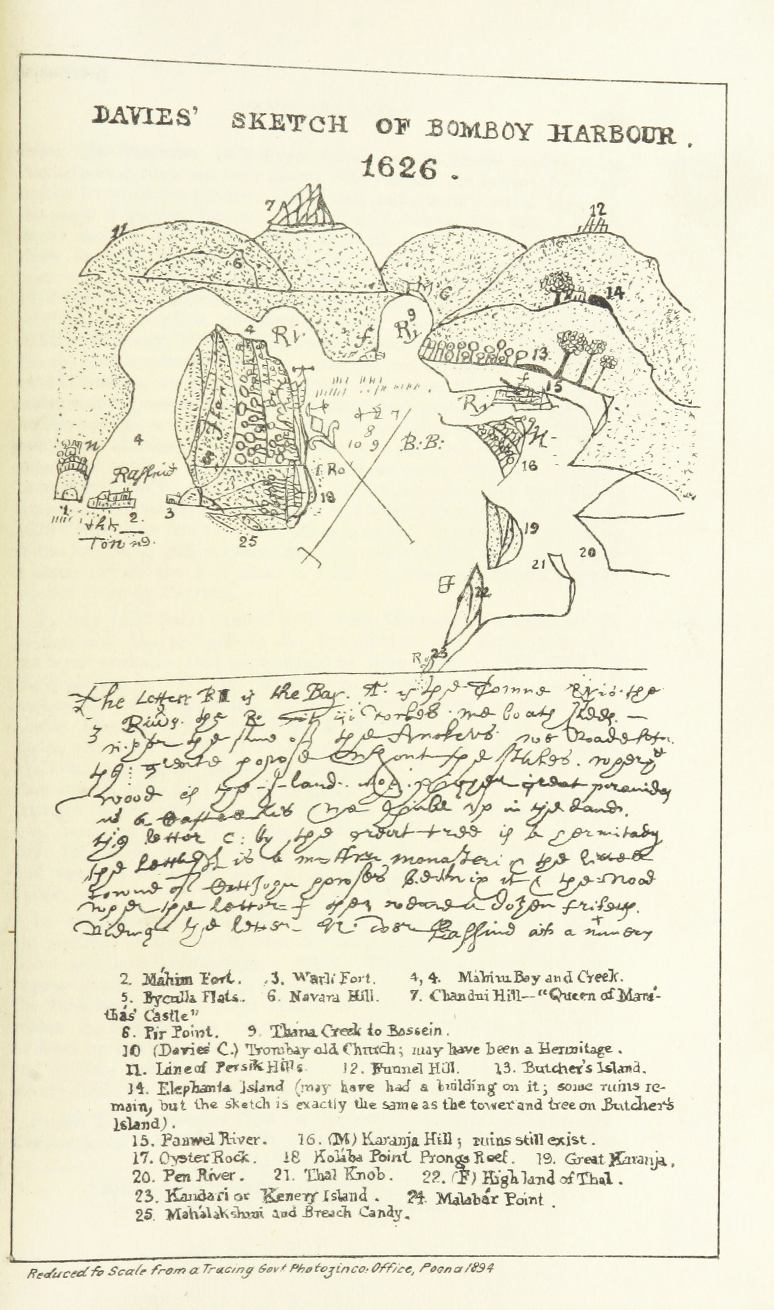
BOMBAY CITY/FORT-NOT YET MADE -BACAIM FORT TO THE NORTH, ISLAND OF TANA AND CHAUL TO THE SOUTH ,OF THE PRESENT MUMBAI CITY

The harbor of Bombay as depicted in William Hacke's A Description of the Sea Coasts. Known as the "Buccaneer's Atlas," this manuscript work was compiled in London about 1690
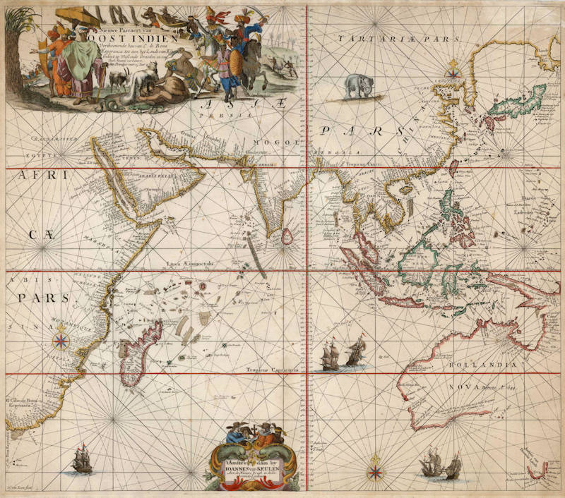

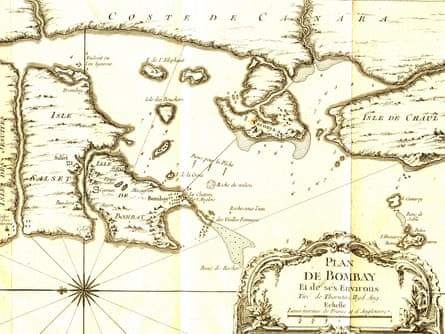
Bombay Antique Map ,by van Keulen, Bombay
|
BAMBAIM(BOMBAY)
 |
| BAMBAIM(BOMBAY)MUMBAI-portugese map 1630 |

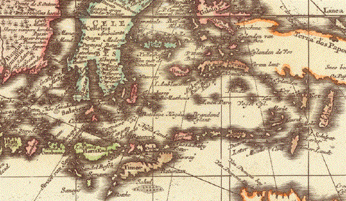
map Bombay/india-1740
below map cambay to malabar including bombaim area

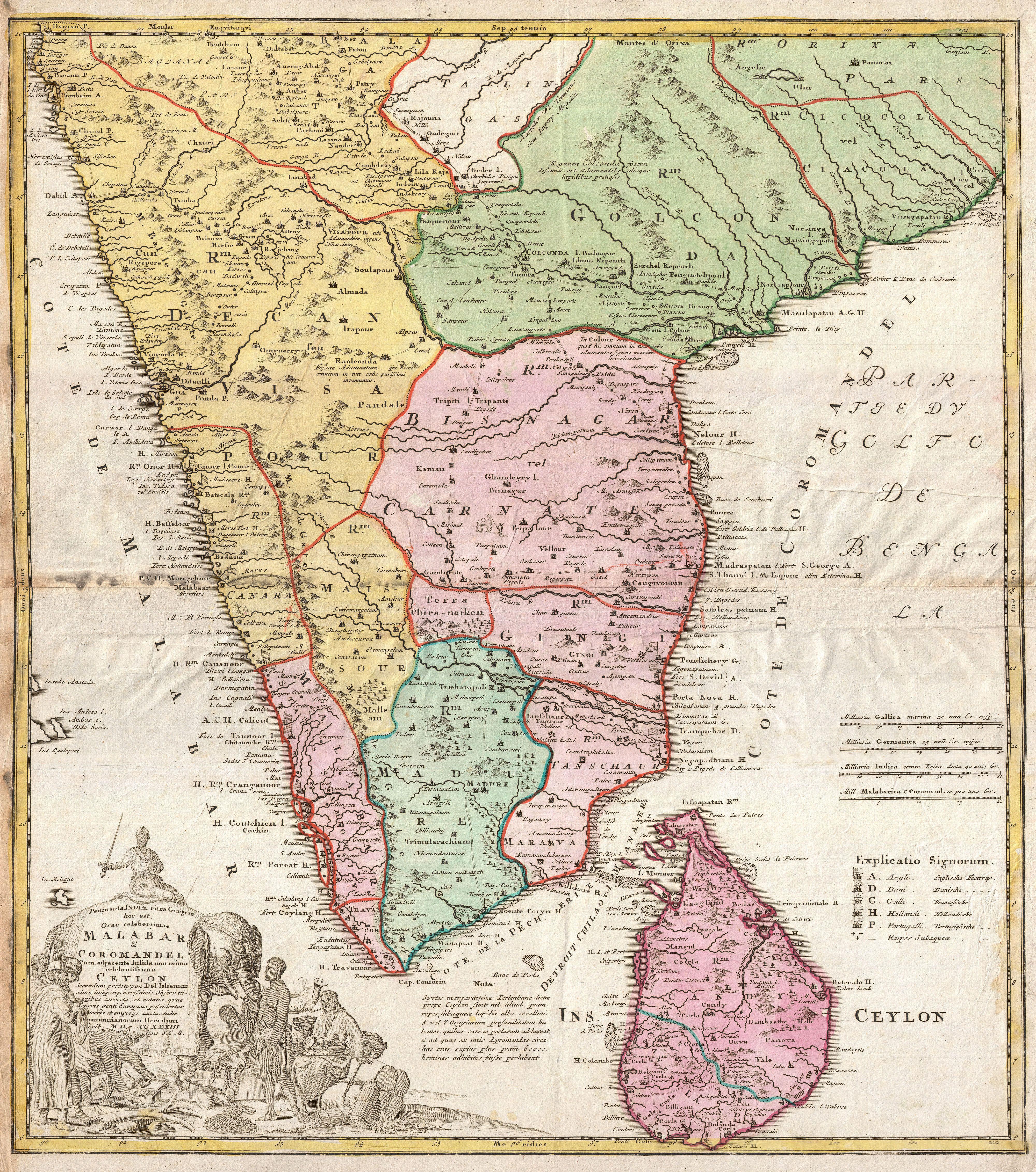
| Title | Descriptio Nova Imperii Malabar, Canara, Decan et Aliarum Provinciarum |
| Maker | Churchill / Baldaeus |
| Year | 1744 |
| Description | Antique map ( copper engraving) of the Malabar Coast. This map was published in 'The True and Exact Description of the Most Celebrated East - India Coast of Malabar and Choromandel as also of the Island of Ceylon' by Philip Baldaeus (first printed in 1672), part of 'A Collection of Voyages and Travels, some now first printed from original manuscripts others now first printed in English', printed in 1744 for Henry Lintot and John Osborn. |
| Location/Subject | Antique maps of Asia / Malabar /Bombaim/ India |
![Antique Map of Malabar,Coromandel and Ceylon [ Sri Lanka] 'Penin](https://lh3.googleusercontent.com/blogger_img_proxy/AEn0k_u6SVjhb1XB274psw9icj80FVfs33sKWCD9YkL9tuMfx1CXmF-Xrq38DPw-zWTVU_zZBeYWL4SW9Exz63PiPNjwTlZ75yyktRmXUo6rJH6U_0l7WUfTBJmqQL3rJNYyQg=s0-d "Antique Map of Malabar,Coromandel and Ceylon [ Sri Lanka] 'Penin")
Title: Antique Map of Malabar,Coromandel and Ceylon 'Peninsula Indiae citra Gangem.....
Author: Homann Heirs
PlaceAndYear: Nuremberg,1733

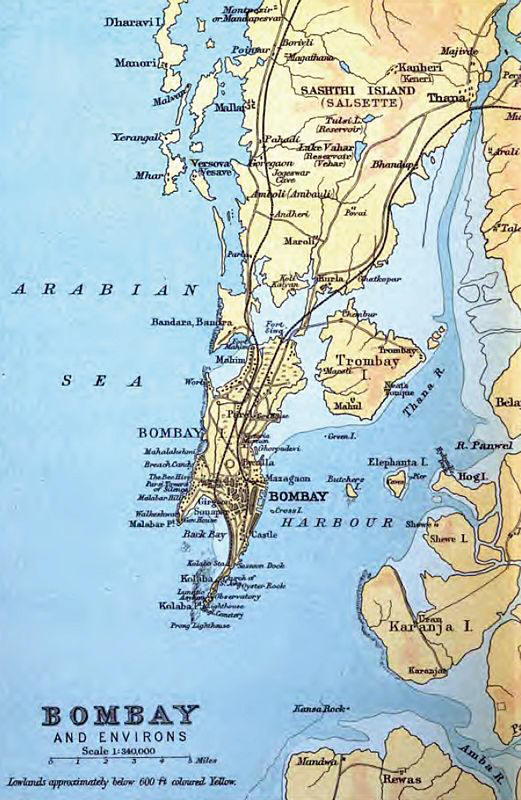
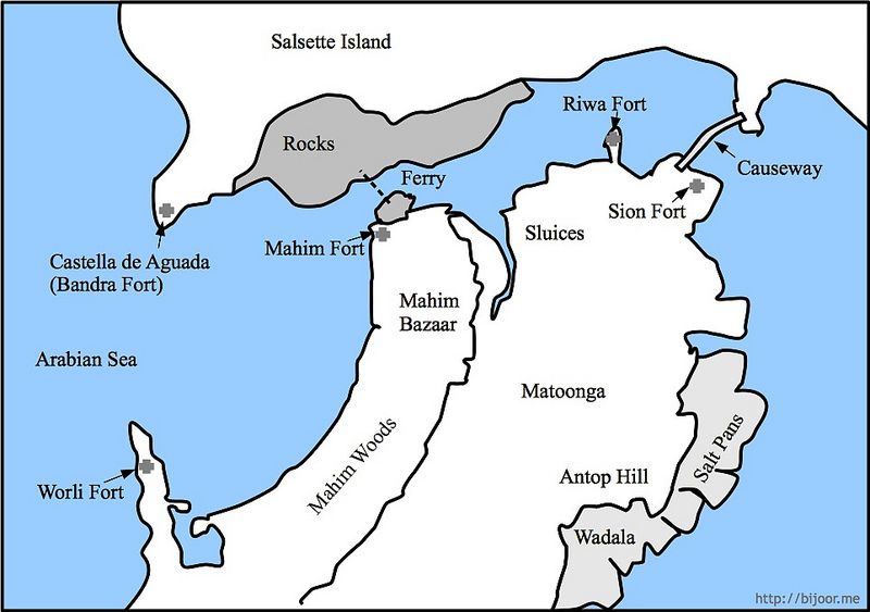
1750: Old Map of Bombay shows forts at Bandura (Bandra), Mayen (Mahim), Mazagoem (Mazgaon), Cayman (Sion) & Bombay Fort
my opinion:- about name BANDURA MEANS BIG HARBOUR=(Van Thura) in malayalam language -at that time malabar pirates from kerala were in charge of this area including Malabar hills

%2C%2CMAYEN(MAHIM)&imgurl=http%3A%2F%2Fwww.ketanjoshi.net%2Fuploads%2F6%2F0%2F3%2F6%2F60363273%2F4367632_orig.jpg&imgrefurl=https%3A%2F%2Fwww.ketanjoshi.net%2Fblog%2Fforts-of-mumbai-mahim-and-bandra&docid=9SoecVZ6NgqKKM&tbnid=xe-uuOBwrE4maM&vet=12ahUKEwj3vJb4wuKGAxVxyzgGHUhTCXsQM3oECBoQAA..i&w=800&h=563&hcb=2&ved=2ahUKEwj3vJb4wuKGAxVxyzgGHUhTCXsQM3oECBoQAA)


But the Portuguese had stationed boats at Bandra, and all Alishah's vessels but seven were taken. Of the seventy-three prizes thirty-three were fit for work and were kept; the rest were burned. Besides the vessels many prisoners were made, and much artillery and abundance of ammunition were taken.[Feria in Kerr's Voyages, VI. 209, 210. This summary of Faria's account of the battle of Bombay seems to differ in some particulars from the account in De Barros.' Asia (Decada, IV. Part I. 208-210,Lisbon Ed. of 1777). According to De Barros the Portuguese caught sight of the Gujarat fleet off a promontory. As Sylyeira drew near, the Gujrat fleet retired behind the promontory, and he sent some ships to guard the mouth of the river.
When Sylveira drew near, the Gujarat ships set sail and ran into the river, and when they found that the mouth of the river was occupied, they tried to reach Mahim fort, but, before they reached Mahim, they were surrounded and captured by the Portuguese boats which had been sent to, guard the mouth of the creek. This account is not altogether clear. Apparently what happened was that when the Gujrat boats saw the Portuguese, they drew back from the Prongs Point into the Bombay harbour, and when the Portuguese fleet attacked them, they fled up the harbour to the mouth of the river (that is the Bombay harbour or east mouth of the Mahim creek) not daring to try their fortune is the open sea.'
The Portuguese captain learned from his local pilots that the Gujarat fleet probably meant to retreat through the Bandra creek, and accordingly sent boats to guard its mouth. The Gujarat fleet entered the creek by Sion, and, on nearing Mahim, saw the Portuguese boats blocking the entrance of the creek.
To avoid them they made for the Musalman fort of Mahim, at the south end of the present Bandra causeway, but the Portuguese saw their object and coming up the creek cut them off,
De Barros' account has been supposed ('Lateen' in Times of India, 21st April 1882) to favour the view that the fight was not in the harbour, but in the open sea off Malabar point. To this view the objection are, that when the Gujarat fleet retired behind Colaba point on catching sight of the Portuguese, they must have gone into Back Bay a dangerous and unlikely movement. That if they came out again to fight, they must have seen the Portuguese boats being sent on to Bandra, and that when, in their flight, the Gujarat fleet found the mouth of the Bandra creek blocked, they could not have attempted to take shelter in Mahim.
the attempt to take shelter in Mahim, when the mouth of the creek was found to be blocked, shows that the Gujarat fleet was leaving not entering the Bandra or Mahim river.]


![Bombay Photo Images[ Mumbai]: SOME MAPS ...](https://www.google.com/imgres?q=Title%3A%20Antique%20Map%20of%20Malabar%2CCoromandel%20and%20Ceylon%20%27Peninsula%20Indiae%20citra%20Gangem.....%0D%0AAuthor%3A%20Homann%20Heirs%0D%0APlaceAndYear%3A%20Nuremberg%2C1733&imgurl=http%3A%2F%2Fwww.columbia.edu%2Fitc%2Fmealac%2Fpritchett%2F00routesdata%2F1700_1799%2Fmalabar%2Fmalabarmaps%2Fbenard1782g.jpg&imgrefurl=https%3A%2F%2Foldphotosbombay.blogspot.com%2F2014%2F04%2Fsome-maps-of-bombay-before-bombay-city.html&docid=CB563HUfTQRL2M&tbnid=XIVFmBySyW_N4M&vet=12ahUKEwix-5z9wOKGAxVWwjgGHVB_CZwQM3oECD0QAA..i&w=800&h=600&hcb=2&ved=2ahUKEwix-5z9wOKGAxVWwjgGHVB_CZwQM3oECD0QAA)


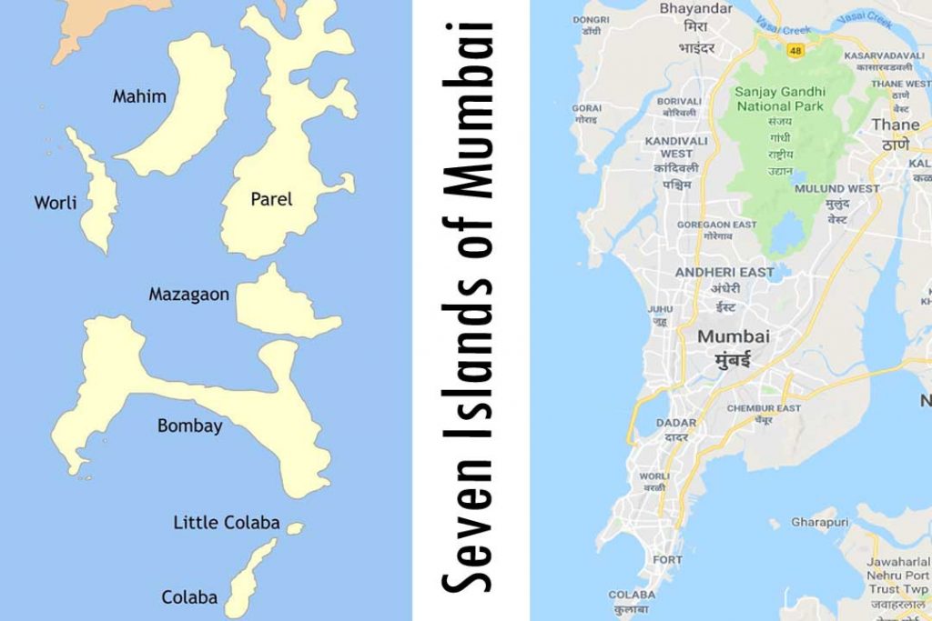
THE ORIGINAL 7 ISLANDS OF BOMBAY(MUMBAI)
... a view from above of the seven islands which initially made up the settlement of Bombay (now Mumbai), together with Salsette Island.
Bombaja Fort, Bombay, 1700

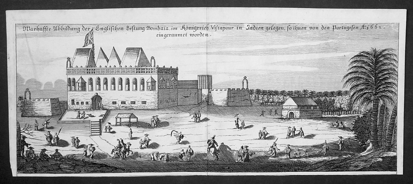
"Bombaia, in the realm of Visiapour": a view from 1703

VIEW OF BOMBAY FORT AND HARBOUR1702
Another painting of Bombay fort under East India company-1700'S

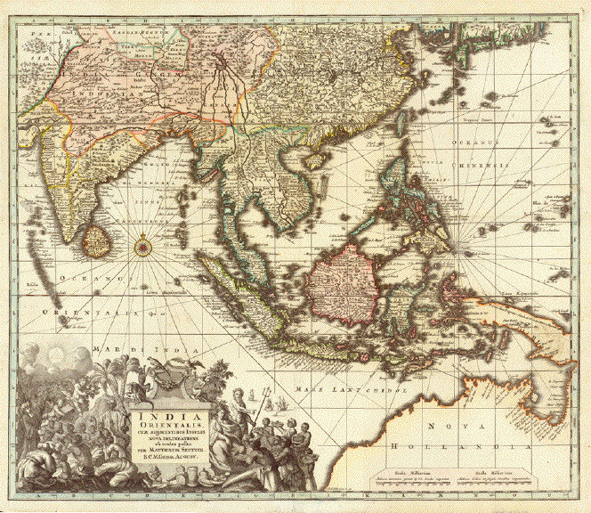
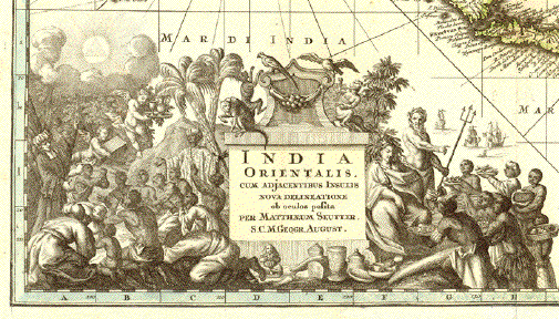
"India Orientalis cum Adjacentibus Insulis Nova Delineatione ob ocolos posita"
Copper engraving map by Matthaeus Seutter. Published in Augsburg 1735.
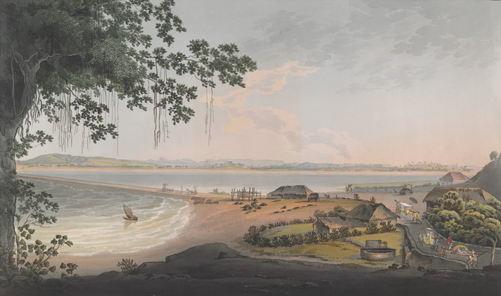
View of Bombay, from Malabar Hills, with the Island of Caranjah and part of the Indian Continent in the Distance

Bombay Views: Twelve Views Of The Island Of Bombay And Its Vicinity Taken In The Years 1791 and 1792. Author: Wales, James / Illustrator: Wales, James London, R. Cribb, 1804 Language: English Source/Shelfmark: X 436, plate 8

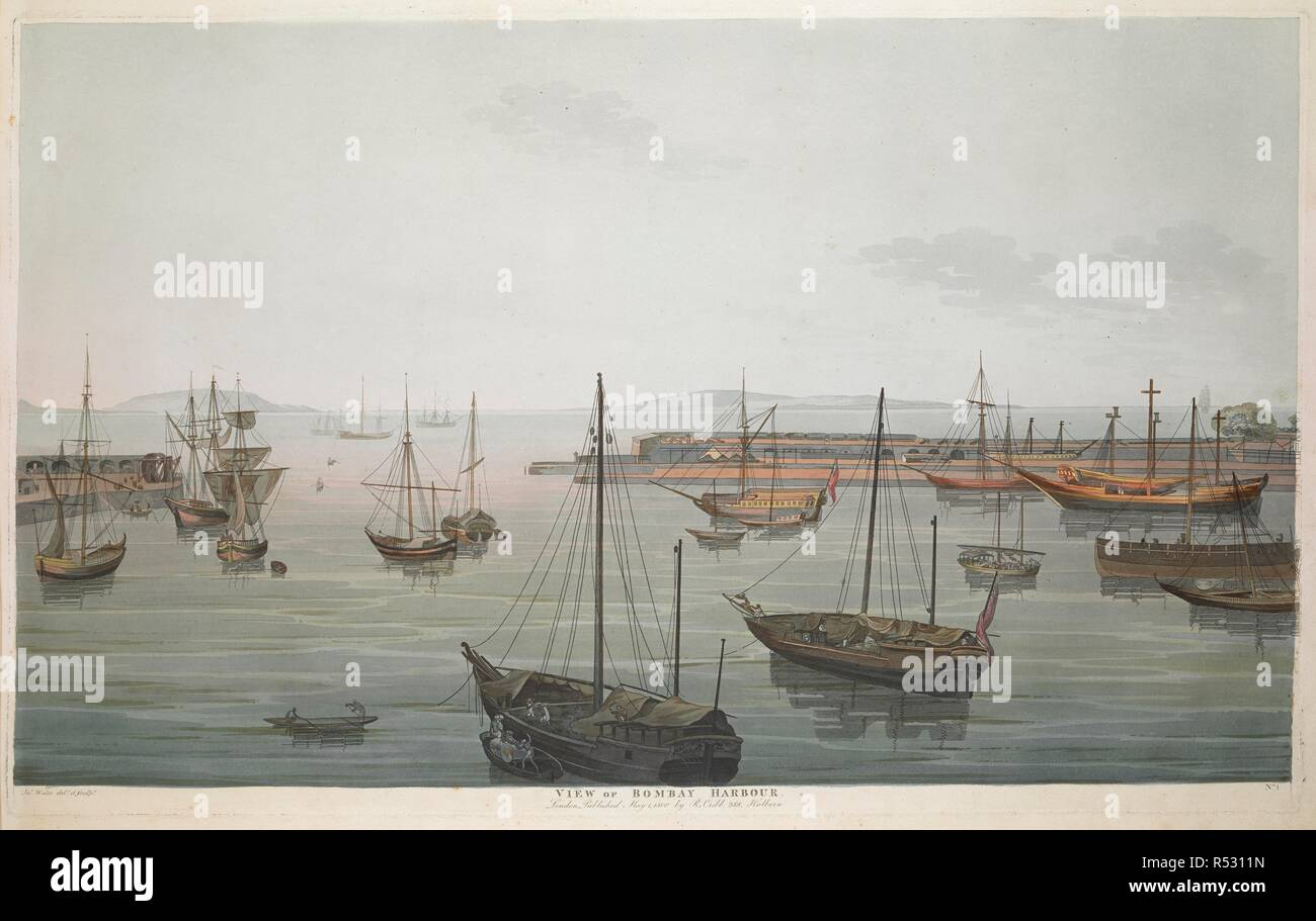
View of Bombay Harbour. January 1870


MALABAR HILLAND PARSEE TOWERS

'Photos of Bombay in 1857

Please click on this image and later ones for larger images.

Bombay - The Esplanade and Colaba in the distance. March 1870 (from the top of Watson's Hotel).--Artist: Lester, John Frederick (1825-1915)-Date: 1871

Lithograph of the Marine Battalion at the Esplanade by Jose M. Gonsalves (fl. 1826-c.1842). Plate 4 from his 'Lithographic Views of Bombay' published in Bombay in 1826. Gonsalves, thought to be of Goan origin, was one of the first artists to practice lithography in Bombay and specialised in topographical views of the city. In 1772, the English feared an attack on Bombay by the French and cleared a semi-circular area of land around the fort to provide a clear line of fire. This area was known as the Esplanade. In the southern section of this area, there was a parade ground known as Marine Lines. This view shows a battalion soldiers on parade with military bungalows in the background
Bombay Esplanade from our(soldier's) Tents. March 1870'.
History:
Hornby Vellard
HORNBY VELLARD
view of "hornby vellard" area sea now below

Hornby Vellard Archives – Rajesh 
Why is Hornby Vellard

Bombay Harbor with guns from Apollo Bunder.--Photographer: Unknown Medium: Photographic print Date: 1855

A photograph of a view of Bombay Harbour from Appolo Bundar from the 'Vibart Collection of Views in South India' taken by an unknown photographer about 1855.The East India Company’s navy was founded at the beginning of the 18th Century to protect shipping against pirates and the maritime Mahratta states. Ships were built in Britain and locally and eventually the fleet was sufficiently powerful to be able to go into action anywhere between the Red Sea and China.
Marine Battalion, Esplanade.-BOMBAY-Artist: Gonsalves, Jose M. (fl. 1826-c.1842) Medium: Lithograph Date: 1826

Lithograph of the Marine Battalion at the Esplanade by Jose M. Gonsalves (fl. 1826-c.1842). Plate 4 from his 'Lithographic Views of Bombay' published in Bombay in 1826. Gonsalves, thought to be of Goan origin, was one of the first artists to practice lithography in Bombay and specialised in topographical views of the city. In 1772, the English feared an attack on Bombay by the French and cleared a semi-circular area of land around the fort to provide a clear line of fire. This area was known as the Esplanade. In the southern section of this area, there was a parade ground known as Marine Lines. This view shows a battalion soldiers on parade with military bungalows in the background.
BOMBAY-Back Bay in 1861.-Photographer: Johnson, William Medium: Photographic print Date: 1861

Photograph taken by William Johnson in 1861, of Back Bay in Bombay (Mumbai), Maharashtra, from an album of 40 albumen prints taken in the 1860s. The busy port and industrial hub of Bombay is the capital of Maharashtra. During British rule, it was the administrative capital of the Bombay Presidency. Extending over a peninsula into the Arabian Sea on the west coast of India, Bombay prospered with maritime trade and became the chief commercial centre of the Arabian Sea. Originally a collection of fishing villages of the Koli community built on seven islands, Bombay was by the 14th century controlled by the Gujarat Sultanate who ceded it to the Portuguese in the 16th century. In 1661 it was part of the dowry brought to Charles II of England when he married the Portuguese princess Catherine of Braganza. In the 19th century, Bombay burgeoned with economic activity and grew huge. Land reclamation along Back Bay provided for further development. Back Bay is located at the southeast tip of Bombay, near the fort and central district. In this view local craft are beached in the foreground.

Aquatinter: Clark, J. (fl.1789-1834)
Medium: Aquatint, coloured
Date: 1813
Coloured aquatint of the Fleet under Convoy of H. M.'s Ship 'Chiffone' Captain Wainwright leaving Bombay in Maharashtra by J. Clark (fl.1789-1834) after an original drawing of September 14th 1809 by Robert Temple (fl.early 1800) of the H. M. 65th Regiment and published in London in 1813.
In 1674, Bombay replaced Surat as the headquarters of the English East Company in India. The esplanade, seen in the foreground of this view, provided a clear range of fire from the fort and was added in the 1770s to protect the city from the French.
Back Bay, Bombay.--Photographer: Johnson and Henderson Medium: Photographic print Date: 1855

A photograph of the Back Bay in Bombay from the 'Vibart Collection of Views in South India' taken by Johnson & Henderson about 1855. Originally, Bombay was composed of seven islands separated by a marshy swamp. It’s deep natural harbour led the Portuguese settlers of the 16th Century to call it Bom Bahia (the Good Bay). The British Crown acquired the islands in 1661when Catherine of Braganza married Charles II, as part of her marriage dowry. It was then presented to the East India Company in 1668. The second governor, Gerald Aungier, developed Bombay into a trading port and centre for commerce and inducements were offered to skilled workers and traders to move here. Back Bay is located on the southeast tip of the island near the fort, the central business district and the area known as Colaba.The Back Bay Reclamation Project was originally proposed in 1865, started in 1913, sidelined by government regulations until 1922, abandoned in 1930, proposed again in 1950 and finally completed in 1970.
Bombay Green of 1862.

Thana Fort on the Island of Salsette seen from the Esplanade. Camels and European figures in the foreground Artist: Heen, A. van der (fl. 1782) Medium: Wash Date: 1752

Wash drawing by A. van der Heen (fl. 1782) of Thana Fort on the Island of Salsette near Bombay in Maharashtra, seen from the Esplanade, with camels and European figures in the foreground, dated 1782. The image is inscribed on the back in ink: 'Tanah fort taken from the Esplanade. A. van der Heen fecit, 1782.'
View Of Bombay, From Mazagon Hill.--Artist: Gonsalves, Jose M. (fl. 1826--c. 1842) Medium: Lithograph, coloured Date: 1833

Mazagon hill was an outlying suburb of Bombay and became a fashionable place to live in the 18th century. Bungalows and plantation houses were built by the British and more affluent Indians moving out of the crowded fort area. During the 19th century, Mazagon experienced a decline as residents moved into the fashionable Bycullah area nearby. The docks were reclaimed towards the end of the century and Mazagon was left landlocked; eventually the fumes from the developing mills drove out any remaining affluent residents.
Hill Fort, Poorandhur--Artist: Nash, Alexander (fl. 1834-1846) Medium: Pencil on paper Date: 1844

Pencil drawing of Purandhar Fort by Alexander Nash (fl. 1834-1846) between 1844 and 1845
View from Sion Fort --Artist: Wales, James (1747-1795) Medium: Etching, coloured Date: 1800

From the vantage of Sion fort, the view opens out to the island of Mahim, which was occupied by the Portuguese in the 16th century. In the 1670s the convent of Our Lady of Salvation was built on the island, and a Franciscan church constructed in what is now Dadar. In the 17th century, the Englishman John Fryer wrote of a customs house and a guard house on the island.
Street scene in the Fort area, Bombay.--Photographer: Bourne and Shepherd Medium: Photographic print Date: 1870

This view is of a street composed of western Indian wooden architecture in a thriving bazaar[INSIDE FORT BOMBAY1860]
View from the Esplanade of Fort George Bombay towards Mazagon'--Date: 1828

showing the view from Fort George in Bombay towards Mazagaon by William Miller (1795-1836) c.1828. Inscribed on reverse: 'View from the Esplenade of Fort George Bombay towards Mazagon'.
Part of the Fort and fort wall, Bombay, 1863.--Photographer: Unknown Medium: Photographic print Date: 1863

Photograph taken shortly before the demolition of the rampart and moat of the Fort in Bombay (Mumbai), Maharashtra, by an unknown photographer, from an album of 40 prints of the 1860s. The busy port and industrial hub of Bombay is the capital of Maharashtra. During British rule, it was the administrative capital of the Bombay Presidency. Extending over a peninsula into the Arabian Sea on the west coast of India, Bombay prospered with maritime trade and became the chief commercial centre of the Arabian Sea. Originally a collection of fishing villages of the Koli communitybuilt on seven islands, Bombay was by the 14th century controlled by the Gujarat Sultanate who ceded it to the Portuguese in the 16th century. In 1661 it passed to the English as part of the dowry brought to Charles II by the Portuguese princess Catherine of Braganza. The British built up fortifications around Bombay harbour in the 17th century around the original Portuguese settlement. In the 1760s the fortifications were enhanced as the British were engaged in war with France in both Europe and India. By the 19th century the British had established control over India and the fort walls were torn down and the area converted into the central district of Bombay city.
Part of the Fort, Bombay in 1864.--Photographer: Unknown Medium: Photographic print Date: 1864

Photograph with a view looking towards a street of private houses at the Fort perimeter, after the removal of the ramparts, in Bombay (Mumbai), Maharashtra, taken by an unknown photographer, from an album of 40 prints of the 1860s. The busy port and industrial hub of Bombay is the capital of Maharashtra. During British rule, it was the administrative capital of the Bombay Presidency. Extending over a peninsula into the Arabian Sea on the west coast of India, Bombay prospered with maritime trade and became the chief commercial centre of the Arabian Sea. Originally a collection of fishing villages of the Koli communitybuilt on seven islands,
Bombay was by the 14th century controlled by the Gujarat Sultanate who ceded it to the Portuguese in the 16th century. In 1661 it passed to the English as part of the dowry brought to Charles II by the Portuguese princess Catherine of Braganza. The British built up fortifications around Bombay harbour in the 17th century around the original Portuguese settlement. In the 1760s the fortifications were enhanced as the British were engaged in war with France in both Europe and India. By the 19th century the British had established control over India and the fort walls were torn down and the area converted into the central district of Bombay city.
Street in Bombay Fort.--Date: 1860--Photographer: Unknown

Photograph of a street in the Fort area of Bombay (Mumbai), Maharashtra, by an unknown photographer, from an album of 40 prints taken in the 1860s. Bombay, one of the key cities of India, is a major port, busy manufacturing centre and capital of Maharashtra. During British rule, it was the administrative capital of the Bombay Presidency. It extends over a peninsula jutting into the Arabian Sea on the west coast of India. Originally a collection of fishing villages of the Koli community built on seven islands, Bombay was by the 14th century controlled by the Gujarat Sultanate who ceded it to the Portuguese in the 16th century. In 1661 it was part of the dowry brought to Charles II of England when he married the Portuguese princess Catherine of Braganza. The British built up fortifications around Bombay harbour in the 17th century around the original Portuguese settlement. In the 1760s the fortifications were enhanced as the British were engaged in war with France in both Europe and India. By the 19th century the British had established control over India and the fort walls were torn down and the area converted into the central district of Bombay city.
The Fort, Bombay, Harbour face wall,- 1863.--Date: 1863--Photographer: Unknown

North-west view of the fort of Bombay--Date: 1826--Artist: Westall, william (1781-1850)

This is plate 17 from Robert Melville Grindlay's 'Scenery, Costumes and Architecture chiefly on the Western Side of India'. Grindlay (1786-1877) was only 17 when he arrived in India in 1803. He served with the Bombay Native Infantry from 1804 to 1820 and during this period made a large collection of sketches and drawings.
Referring to the fort of Bombay, Grindlay wrote: "The fortifications which were originally commenced by the Portuguese, and subsequently improved by the English, though very strong particularly towards the sea, are too extensive, and require a very large garrison. That part represented in the plate is the north-west extremity, and exhibits a remarkable accumulation of threatening embrasures, commanding the approach from the northern part of the island".
By the middle of the 18th century, the fort area had became too congested and setllements moved outside its walls, with the governor moving in 1750 to Parel. Much of the area was gutted in the great fire of 1803, the year Grindlay arrived.
Interior of Fort,--Date: 1855-- Bombay.-[before fort walls removed] Also Notes on the life inside Bombay fort

1841, February 24th.
— Bombay street notes:-
"The Fort is now a second Augean stable — heat suffocating.
March 24th.
—" We are informed that H. E. has directed that the oval space called Bombay Green, in the centre of which the statue of the Marquis Cornwallis now stands, is to be neatly laid out and railed in as a garden
Sir Robert Grant
suggested the planting of all the roadsides with trees. Now un fait accompli, well and truly done."
October 12th. —
" The unhealthy position of the Colaba Barracks is now fully demonstrated." All nonsense. The two Napiers put this all to right.
1849, February 16th. —
" Our nuisances are the barking of pariah dogs at night. Ferocious dogs attack people at ChurCH Gate at night." I am afraid they are like the poor, " always with us."
1850, September. —
" Eumour that Elephanta is to be turned into a tavern and ball-room." More nonsense.
The next fond anticipation has been answered by the custodians
1850:-
locking the Elphinstone Garden gates at sundown. " Bombay Green — a swamp in monsoon and a receptacle of stones and dust in fine weather. Shall we ever see fond lovers there, sitting under the shade of umbrageous trees " ?
November. —
" Children not burned, but buried in the sands of Back Bay."
1851, May. —
"The moat round Bombay, 2| miles in length, is now dry from end to end, and was never dry before."
1852, June 18th. —
" The Fort is no cleaner nor more savory than it was in your time " (say 1832).
1852, April 11th. —
" A monster petition to the Court of Directors, London, from the inhabitants of Bombay, against any building being erected on Bombay Green.Copy sent to every firm or individual in England who knew Bombay."
1853, November 19th. —
" Saw a corpse strung by four cords jostled through the streets to its shallow hole in the sands of Back Bay."
1854. —
"Hornby Eow is one of the filthiest streets in Bombay." Many letters in the papers on the Main Drain Nuisance.
August 19th. —
" The Town Hall is now in a very dirty condition ; the stairway the resort of idle gamblers and so forth.
November. —
" Corpses floating in harbour after the Great Storm. Public notice to abstain from fish, as was done in 1827 and '37."
1856, September 9th. —
" Vehar works in progress."
1857, October 20th. — " Dr. Buist proposes to cover the main
drain." A most earnest and useful man. Who knows if the
seeds of his illness and death were not sown in such foul
surroundings ?
1858, May 15th. —
" The sanitary condition of Bombay is a disgrace to us all."
1859, May 17th.—
" Ditch fearfully foul."
1860, February 29th. —
"From Colaba Church to the light- house the stink might be cut with a knife.
" May 3rd. — "A
(THE BLACK DEATH)[PLAGUE DEATH]
Goanese corpse from the Jejeebhoy Hospital was left at Sonapore Churchyard and eaten by vultures and dogs."
Government House, Fort, Bombay--Date: 1826--Artist: Gonsalves, Jose M. (fl. 1826-c.1842)

Lithograph of the Government House in the Fort in Bombay by Jose M. Gonsalves (fl. 1826-c.1842). Plate 2 from his 'Lithographic Views of Bombay' published in Bombay in 1826. Gonsalves, thought to be of Goan origin, was one of the first artists to practice lithography in Bombay and specialised in topographical views of the city.
This view of the Government House in the fort area of Bombay was taken from Bombay Green. On the right is the monument to Marquis Cornwallis, the Governor-General and Commander in Chief in India from 1786 to 1793. The location of the Government House in Bombay changed several times. Originally, the Government House was located in Bombay Castle. The second Government House, shown in this view, was situated in the fort area on Apollo Street and functioned as the official residence of the Governor until 1829. The third Government House at Parel had already been used as a Country retreat for the Governor from 1719. In the 1880s, the location of the Government House was moved once again to Malabar Point.
Scene in Bombay--Date: 1826--Artist: Grindlay, Robert Melville (1786-1877)st Thomas cathedral seen

Grindlay explains that in 1811, the Bombay 'Green' was "an irregular area, surrounded by various public buildings and originally intended for the Garrison-Parade; but occupied during the dry season by vast piles of cotton bales, marine stores, and various bulky articles of merchandise."
Bombay fort' General view of Bombay. Arthur Willmore --Date: 1840

Engraving of a general view of Bombay by Arthur Willmore (1814-88) after Thomas Allom (1804-1872) and dated c.1840. The area of Bombay was originally composed of seven islands. In 1661, these islands were acquired by the British Crown from the Portuguese as part of the marriage dowry of Catherine of Braganza when she married Charles II. From 1668, the East India Company leased the land from the British Crown and developed the area as a trading port. A manor house of the Portuguese, situated on Bombay Island, provided a suitable site for the fort. A custom house, warehouse, quay and fortifications were also built soon after. In the 18th century, the town surrounding the fort was developed. This included the contruction a number of public buildings, the creation of outer fortifications and the clearance of land surrounding this area. In this view, the flagstaff within this area is shown. By the 1860s, the need for military defence lessened and Governor Sir Bartle Frere demolished the fort walls. As a result, Bombay underwent an ambitious phase of building in the Victorian style.
'View in Basseen Fort'. Captain James Barton's 12 Views of Hill Forts in the Western Ghats near Bombay, London, c.1820.

A TEMPLE NEAR TO PORTUGESE CHURCHES IN THE BASSEIN FORT[VASAI FORT]1820
Coloured lithograph of a view in Bassein Fort by Rudolph Ackermann (1764-1834) after Captain James Barton (1793-1829) plate 7 of Barton's 12 Views of Hill Forts in the Western Ghats near Bombay published in London c.1820. Bassein (Vasai) is situated at the mouth of the Ulhas River north of Bombay. In 1534, the Portuguese seized Bassein from Bahadur Shah, the Sultan of Gujarat, and the town remained in their control for just over 200 years. At the height of its prosperity, Bassein had 5 convents and 13 churches. In 1739, Bassein was taken by the Marathas. In 1802, the British secured the Treaty of Bassein with Peshwa Baji Rao II, which allowed British forces to be stationed in Maratha territory.

Sewri Fort, Bombay, looking across to Trombay Island. An officer, probably a self portrait, is shown sketching
Date: 1828--Artist: Miller, William (1795-1836)

Pen and ink drawing of Sewri Fort in Bombay looking across to Trombay Island by William Miller (1795-1836) in 1828.The image is inscribed: 'Suree from below the Band hill. Bandalah. W.M. December 1828'.
Sewri Fort was located on the eastern shore of Parel Island and constructed in 1770. Parel Island, along with Trombay, was one of seven that originally made up the area of Bombay. The artist, William Miller, had a house at Parel. It was located at Vadalla between the towns of Sewri and Matunga. In this view an officer is shown sketching on the left. This figure is probably a self portrait of the artist.

Photograph of Kalbadevi, Bombay from 'Views in the island of Bombay' by Charles Scott,1850s. The area of Kalbadevi was named after the shrine dedicated to the goddess Kali in this area. In the 18th and 19th century, Hindu immigrants from Gujarat, Kathiawar, Kutch and Marwar moved to Bombay to escape famine and drought in their homelands and settle in Bombay, where there was economic growth and prosperity. Kalbadevi was one of the areas where they settled. Some of the houses drew inspiration from Gujarat or Rajasthan, the areas where the residents came from. Kalbadevi was also a busy commercial centre with the Gujarati and Marwari Jewellers conducting thei
A view at Calbadavie [Bombay].--Date: 1850--Photographer: Scott, Charles

Cotton stores, Bombay.-Date: 1855-Photographer: Johnson and Henderson

A photograph of a view of a cotton warehouse, Bombay from the 'Vibart Collection of Views in South India' taken by an unknown photographer about 1855.Before the mid 19th Century, India used to export cotton to Britain, and then reimport cloth. The impetus towards the founding of a cotton industry came from Indian entrepreneurs; the first mill, ‘The Bombay Spinning Mill’, was opened in 1854 in Bombay by Cowasji Nanabhai Davar. Opposition from the Lancashire mill owners was eventually offset by the support of the British manufacturers of textile machinery. Cotton exports from India took off during the American Civil War, when supplies from the USA were interrupted.
File:Malabar Hill, Mumbai. 1850s.jpg


Malabar_Hill,_Mumbai._1850s.jpg (712 × 524 pixels, file size: 137 KB, MIME type: image/jpeg)
Bombay, from Malabar Hill-date: 1855--Photographer: Johnson and Henderson
A photograph of a view of Bombay from Malabar Hill from the 'Vibart Collection of Views in South India' taken by an unknown photographer about 1855. Originally, Bombay was composed of seven islands separated by a marshy swamp. It’s deep natural harbour led the Portuguese settlers of the 16th Century to call it Bom Bahia (the Good Bay). The British Crown acquired the islands in 1661when Catherine of Braganza married Charles II, as part of her marriage dowry. It was then presented to the East India Company in 1668. The second governor, Gerald Aungier, developed Bombay into a trading port and centre for commerce and inducements were offered to skilled workers and traders to move here.
please note:- The second governor, Gerald Aungier, developed Bombay into a trading port and centre for commerce and inducements were offered to skilled workers and traders to move here.

BOMBAY-1850-MALABAR HILL -Photographer: Scott, Charles
Photograph looking at the eastern part of Malabar Hill, Bombay from 'Views in the island of Bombay' by Charles Scott,1850s. Malabar Hill, the highest point in Bombay, is where the Silhara Kings (r.810-1260) founded the original Walkeshwar Temple. The temple was destroyed by the Portuguese and rebuilt in 1715 by Rama Kamath. By 1860, the temple attracted many people and there were 10 to 20 other temples around it and 50 dharamshalas. Fairs were held near the temple.
Mountstuart Elphinstone built the first Bungalow in Malabar Hill during his governorship from 1818 to 1827. After this many more people built houses here and the area became a posh locality which it still remains.
WILD ANIMALS INCLUDING TIGERS WERE REPORTED ON MALABAR HILL 1850

BASSEN FORT(VASAI FORT) BOMBAY-1780

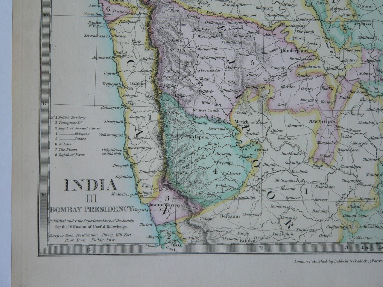
Proceeding roughly south to north, the seven islands ceded by the Portuguese to the British were
|
British soldiers captured these islands only in 1665, and a treaty was signed in the manor house on the island of Bombay.
The first four governors held Bombay for the Crown:-
| 1 | Abraham Shipman | 19 March 1662 | October 1664 | 2 | |
| 2 | Humphrey Cooke | February 1665 | 5 November 1666 | 1 | Acting |
| 3 | Gervase Lucas | 5 November 1666 | 21 May 1667 | 1 | |
| 4 | Henry Gary | 22 May 1667 | 23 September 1668 | 1 | Acting |
| 1 | George Oxeden | 23 September 1668 | 14 July 1669 | 1 | ||
| 2 | Matthew Gray | 14 July 1669 | 7 June 1672 | 3 | Acting | |
| 3 | Gerald Aungier | 7 June 1672 | 30 June 1677 | 5 | ||
| 4 | Henry Oxenden | 30 June 1677 | 27 October 1681 | 4 | ||
| 5 | John Child | 27 October 1681 | 27 December 1683 | 2 | ||
| 6 | Richard Keigwin | 27 December 1683 | 19 November 1684 | 1 | Acting | |
| 7 | Charles Zinzan | 19 November 1684 | 1685 | 1 | Acting | |
| 8 | John Wyborne | 1685 | 2 May 1687 | 2 | Acting | |
| 9 | John Child | 2 May 1687 | 4 Feb 1690 | 3 | ||
| 10 | Bartholomew Harris | 4 February 1690 | 10 May 1694 | 4 | ||
| 11 | Daniel Annesley | 10 May 1694 | 17 May 1694 | Acting | ||
| 12 | John Gayer | 17 May 1694 | November 1704 | 10 |

Aungier planned extensive fortifications from Dongri in the north to Mendham's Point (near present day Lion Gate) in the south. However, these walls were only built in the beginning of the 18th century. The harbour was also developed, with space for the berthing of 20 ships. In 1686, the Company shifted its main holdings from Surat to Bombay.

Life India-- Elephants Stable--Bullock powered Mill---Bullock cart --


Hill Fort of Mhowle-Lithographer: Ackermann, Rudolph (1764-1834) Medium: Lithograph Date: 1820

Coloured lithograph of the Hill Fort of Mhowle in the Western Ghats in Maharashtra by Rudolph Ackermann (1764-1834) after an original drawing by Captain James Barton (1793-1829). Plate 8 of 'Captain James Barton's 12 Views of Hill Forts in the Western Ghats near Bombay' published in London c.1820. The Western Ghats are a range of hills that reach from the state of Maharashtra to Tamil Nadu and separate Bombay, on the western coast, from central India. This view shows a British encampment in front of a large outcrop of rock at Mowle. The artist, Captain James Barton, was an artillery officer who served in the third Anglo-Maratha war in 1817-19.

Hill Fort on the Island of Caranjah-near BOMBAY-Artist: Forbes, James Medium: Engraving Date: 1813

From Salsette near Bombay, Forbes(1749-1819) sailed to Karanja and landed about two miles from the principal town, situated between two lofty mountains, on the west. He observed that it was: 'nothing more than a large Mahratta village, with low-straggling houses, near a tank covered with wild ducks and water-fowls, hitherto unmolested by Europeans. On its bank a small fort, a Portuguese church and a Hindoo temple embellished the view. It commands a western view of the town and harbour of Bombay, Salsette and all the adjacent islands, and to the east the mountains of the continent, and nearer plains of Caranjah; abounding in rice-fields, coco-nut, palmyra, mango and tamarind trees, filled with monkeys, parrots, owls, and singing-birds of various kinds'.
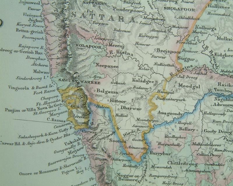
Vishalgad Fort
Vishalgad Fort, nestled amidst the rugged terrains of Maharashtra, stands as a stoic witness to centuries of historical evolution and architectural prowess. This formidable fortress, located in the Kolhapur district, holds a pivotal place in India’s rich history, reflecting the strategic importance it once held and the architectural ingenuity of its builders.

Historically, Vishalgad Fort played a crucial role in the Maratha Empire’s expansion and consolidation during the 17th century. Constructed in the 16th century by Chhatrapati Shivaji Maharaj, the founder of the Maratha Empire, the fort served as a strategic stronghold against the rival Bijapur Sultanate. Its location atop a hill provided a commanding view of the surrounding landscape, allowing for effective surveillance and defense. The fort witnessed numerous battles and sieges, each leaving an indelible mark on its storied walls.
The architecture of Vishalgad Fort is a testament to the military acumen of its creators. The fort’s design incorporates a complex system of bastions, gates, and watchtowers, showcasing an astute understanding of defensive strategies. The massive stone walls, built with locally sourced materials, exemplify the engineering prowess of the time. The fort’s layout is designed to maximize its defensive capabilities, with intricate arrangements of bastions providing overlapping fields of fire, making it a formidable obstacle for any invading force.
One of the notable features of Vishalgad Fort is its well-preserved entrance, known as the ‘Maha Darwaja’ or the Great Gate. This imposing structure, flanked by bastions on either side, served as the primary entry point and played a crucial role in repelling enemy attacks. The architectural detailing on the gate reflects the artistic sensibilities of the period, with intricate carvings and embellishments adorning the stone facade.
The fort also houses various structures that served as living quarters, granaries, and storage facilities. These structures, though austere in design, reflect the pragmatic approach adopted by the Marathas in optimizing space and resources. The water conservation system within the fort, including step wells and reservoirs, underscores the foresight of its builders in ensuring a sustainable water supply during times of siege.
Vishalgad Fort’s historical significance extends beyond its military importance. It served as a center for administrative and economic activities, contributing to the overall prosperity of the region. The fort’s association with Chhatrapati Shivaji Maharaj, a visionary leader and strategist, adds to its historical allure. The tales of valor and resilience associated with Vishalgad Fort have become an integral part of Maharashtra’s cultural and historical narrative.
Vishalgad Fort stands as a monumental testament to India’s rich history and architectural heritage among other monuments in Maharashtra. Its strategic significance in the Maratha Empire, coupled with its resilient design, highlights the military prowess of its builders. The fort’s well-preserved structures and historical associations make it a compelling destination for history enthusiasts and tourists alike, offering a glimpse into a bygone era when fortresses like Vishalgad played a pivotal role in shaping the course of Indian history.
The Fort of Visiadroog - Southern Koncan. One of a series of Views in India and in the vicinity of Bombay


1858-BOMBAY FORT
")
Commencement of the Reservoir, in the Valley of Vehar, Island of Salsette," Illustrated London News, 1856*

1770-BOMBAY

The Strait Between the Islands of Bombay and Salsette(before mahim causeway/bridge was made) by William Carpenter (1818-99). Watercolour on paper.
| ||||

A general view of a British station Date: 1860. Image from Mary Evans - Prints Online

Lord Hastings' flotilla on the river, with many pinnace budgerows--Artist: Sita Ram (fl. c.1810-1822) Medium: Watercolour Date: 1814


A View of Black Wall with part of the Yard--Artist: Dodd, R Medium: Engraving Date: 1789

A Hindoo Fair, a wood engraving from the Illustrated London News, 1858
TAXIS (PULKHI) WAITING FOR CUSTOMERS IN BUSINESS AREAS OF BOMBAY FORT -1800'S

Malabar hill and beach -post card 1900's
A view from Malabar Hill, Mumbai


malabar hill and chowpatty beach 1900's


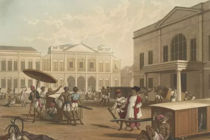
TOWN HALL BOMBAY 1800'S -FORT WALL AND HARBOUR WITH SHIP MASTS CAN BE SEEN THE OPEN GROUND IN FRONT OF TOWN HALL WAS KNOWN AS BOMBAY GREENS WHERE OPEN AIR HAGGLING FOR COTTON BUNDLES AND OTHER EXPORT ITEMS TOOK PLACE .
BELOW ANOTHER VIEW OF BOMBAY GREEN TAKEN FROM TOWN HALL

EAST INDIA COMPANY SOLDIER'S MARCH PAST WITH 2 BOY DRUMMERS IN THE REAR SEEN IN MID GROUND ,COTTON BUNDLES READY FOR EXPORT WITH LOADERS SITTING ON TOP OF IT CAN BE SEEN,ENGLISH OFFICER BEING CARRIED ON A PULKHI WITH TWO SOLDIERS WITH DRAWN SWORDS IN FRONT NEXT TO THE COTTON BUNDLES ,ST THOMAS CATHEDRAL IN THE FAR BACK GROUND,A CHARIOT PRECEDED BY A MUSIC BAND IN THE BACK GROUND,
TWO MERCHANTS IN FLOWING ROBES ON EXTREME RIGHT NEXT TO
TWO ENGLISH GENTRY POSSIBLY HAGGLING OVER MERCHANDISE-1780

BOMBAY GREEN 1830,ST THOMAS CATHEDRAL CHURCH IN BACK l showing the Cornwallis monument

BOMBAY GREEN PHOTO 1850l showing the Cornwallis monument
BOMBAY GREEN SHOWING COTTON BUNDLES FOR EXPORT,WORKERS WEIGHING BUNDLES ON A TRIPOD SHAPED WEIGHT MACHINE,MERCHANTS IN FLOWING ROBES AND CAPS,HAMALS/LOADERS-MEN IN SCANTY CLOTHS WOMEN IN SARIS GOSSIPING? -LIFE WENT ON THEN AS IT IS NOW

BOMBAY TOWN HALL PHOTO 1850'S WITH BOMBAY GREEN GROUND AS SEEN FROM THE TOP OF THE ST THOMAS CATHEDRAL,SAILING SHIPS IN HARBOUR IN THE BACK GROUND

COTTON MARKET BOMBAY NEXT TO BOMBAY HARBOUR 1860,SHIPS WITH MASTS CAN BE SEEN

THE FIRST STAR HOTEL OF INDIA -WATSON HOTEL-CAN BE SEEN IN THE FOREGROUND AS MULTI STORY BUILDING WITH OPEN VERANDAHS-1890[BEFORE TATA WAS CHUCKED OUT OF THE HOTEL AS A DARK SKIN INDIAN,BEFORE TATA MADE TAJ MAHAL HOTEL IN RETALIATION]

TOWN HALL BEFORE DISCOVERY OF CAR/AUTOMOBILES-1880'S

The Town Hall and part of Elphinstone Circle Gardens[BOMBAY GREENS]The garden was planned in 1869 and completed in 1872 with well laid out walkways and trees planted all around.

Elphinstone Circle Gardens[BOMBAY GREENS]

HARBOUR BOMBAY-NEAR TO Elphinstone Circle Gardens[BOMBAY GREENS]

BOMBAY GREEN CONVERTED INTO A GARDEN -NOW KNOWN AS HORNIMAN CIRCLE GARDEN

Horniman Circle Gardens - Wikipedia, the free encyclopedia
 |
| Benjamin Horniman 1920 |
B. G. Horniman - Wikipedia, the free encyclopedia

Horniman Circle Garden
https://plus.google.com/114534335881768887204/about?gl=in&hl...Horniman Circle Garden Mumbai, India - Location, Facts ...
www.ixigo.com/horniman-circle-garden-mumbai-india-ne-1314230Horniman Circle Garden Mumbai - Comprehensive travel guide of Horniman Circle Garden in Mumbai, Explore Location, Opening Closing Timings, How to ...Horniman Circle Gardens Mumbai
www.mumbai.org.uk/parks-gardens/horniman-circle-gardens.htmlSituated in the Fort precinct of Mumbai, Horniman Circle Gardens is one among the largest parks in southern Mumbai. This garden is surrounded by various ...Horniman Circle Garden, Fort, Mumbai - Burrp
mumbai.burrp.com/listing/horniman-circle-garden_fort.../1641229445In South Mumbai, Horniman Circle Gardens represents a green territory among the soaring buildings. This large park sprawls in an area of 12,081 square yards,... Mumbai Horniman Circle Gardens - Expedia.co.in
Compare hotel deals near Horniman Circle Gardens in Mumbai. Book with Expedia.co.in & save: lowest prices & instant confirmation.

Government House, India-1800-Thomas Daniell (1749–1840)