

Bombay(mumbai)Portuguese Maps from 1635 AD
When Portuguese ruled most of the west coast of India, they built
fortifications and settlements along the coast and few inland to protect
their trading ships and teritory. These maps show where the
fortifications were. Most or all of the fortifications are now in ruins
however there are some pictures on this site of those ruins and forts.


![Bombay Photo Images[ Mumbai]: SOME MAPS ...](data:image/jpeg;base64,/9j/4AAQSkZJRgABAQAAAQABAAD/2wCEAAkGBxMTEhUTEhIWFhUXGRoaGBgYGR0YGhgdGxsYGB8YHRgYHSggGBolHxoaITEhJSkrLi4uGB8zODMtNygtLisBCgoKDg0OGhAQGy0lHSUtLS0tLS0tLS0tLS0tLS0tLS0tLS0tLS0tLS0tLS0tLS0tLS0tLS0tLS0tLS0tLS0tLf/AABEIAMIBAwMBIgACEQEDEQH/xAAbAAACAwEBAQAAAAAAAAAAAAAEBQACAwYBB//EAEAQAAECBAQEBAQDBwQCAgMBAAECEQADITEEEkFRBSJhcRMygZGhscHwQlLRBhQVI2Lh8TNygrKSolNzk9LTFv/EABcBAQEBAQAAAAAAAAAAAAAAAAABAgP/xAAiEQEBAQADAAICAgMAAAAAAAAAARECEiExQRNRA2EiMkL/2gAMAwEAAhEDEQA/AEeElTMQMyxlCLAOCVMxrdu0NOHYOaqXlmBOXZQc0tWAOCyFF8k3LWqSRQP1fSOimFQSGCZhffKB83McKAleIpAISErSHATX2BFyLC9Y0wMuTOCRmBIcsQyibEkXZ/SMMUgJlNLJdIdgHQ9GDE0uGinDMB/NSsBSHsACA9HFrd4SaNpvB1ghcuZRyQUio3oK02hpjMQt0krIo5vWjbW1gkyAklVElR5i97AAa7e8K+MTiDlQWKfM9XBBI31109YlIqeJTJaBmUFhRLZWcDu9T/h4uZ2VKlpU6WJy5SS7hgAWYtRt1QnwQ8RQDuBU67W6/pDOZiUBJMsigckaEUAI/M9A43OkZvig+CyVLnlaFMEklWhYkslSXub+kN5XEgtf7vPGRamZiyVEvyg7s1NXjmxJWgidUOSQ2gJt0GzbGOqPCkYqXLWosnzct3o9dKxpHuO4GlZClXzFRIoffpT2iuPWtsqFkLY5EuObKxuRXR+/rBPEcb4QShIBLfiJqBo+7PWtrGAv38GX4olMpNFJJ5kg3alXodH+UoH4fxxzlmgpO7M+tR2+UEcRnywkKKAtJZ6nNcWDdyai1YpgpMqcglBLqJK7BRYsA70SLgdRB0rBywjJ+Hver3+MPFDSJqFpdCU5SwIDBn3bW9tjCOZw6cuc6QQBY5nCX0B1vHVGWlAZKabJAp1hVjOKE/6cwCYG/lqAALGoL2LbHR7QlBAwSiGmLUT+YU6tZm0gDH8MWhpkk5FMzDUO7qJvp3MNUlSkusA7hJ5ez69+kAL4guTNql5V1JvkuxCi3MRdIe0IGMpZWAlSGoHILhzftAPE+EKm5RLASE/iNhozXLv/AOohlNn50AjMglizsU61Z37RjhcZMZImFLEFz5T0Dan7aL4gROBRh0KKUOWDlySr2sYph5CzOStBVky8xW5voA4bQ0gmfhpoXmTlMsJZQWo83V2p3gjhuLTMQFeGpIsAQ2g+GnpBQGJ4l4ZyqSSknLS40JpRqjX9IIRITNyTQ9Khw161fV42xQlZ5ecBirKkg2OrjQAge8EYucAgZKp9Kg9fjF8nqFHEZ8xKkqBJQSApPd+lLj2jNXFJa80o8iiD5rNTUHV/nA+PmKQolHMmhIJN9GJfR3FrQTg8JKUBMCS5qQS4ejezdLxjxpfD4VMtASOYg3+7APCvh8+YZqkS1JAzB0lNEhgwDKqCBp1tDLF4fncKuGUihzCuh73hJP8ABKlgA+LmZnYuLMqyR26xYYdYmYoKSUsoF3BBIHXpBmHlsKANplNGvQCggPhhUZQSupa4N/W8BpxBwzsElKi6Ulwobkltb7xdTG/EZ8shctQKSzJJDu9Xfvp0hdwjEqrLmKdNk/mpo8b4WT+9HPMQZbGt+bapsOkH4qYlIseUO7U2eKFryxTw7U8pPxESNJmAKzmTNWAbMzelI9i+DAITLQFy6Fnc1to1676Qx4XxDxQQpkzE3BFKa2tcRkogys6WAId1BwlnLkE/LVoYYLCy0odBDHUN8Nu0ZFMPwrMpa/EZKixCWLkXe7H5Rnj+NiU2VAKRQf2+fWMcalclXiJVlCzzJFQXYOU3J6jtG8nDoUlMyhY0y81bW0PyhdSCsJj5UzKc7EGqVUU5sC+mrbtC/jqAvWialQA9QDewikzABDFS2qzE6nUncn2jDFyT5HersLb16at0hflV+GyVS3My5oLe9NPveA8LKl+M00BCkhrU/MHUA1i1doa8FwMtJUlS3WGdOz2J6MbwFiRJE7JOBASQBk8rqObMoku7ZaVZ4mehjjsAJiHlkKchzcVIcDrY9ADvGngoRL8NBcjNUp1S5sQwY6/rB5khMomWXYEjKBXX1eBsDiVrlAmUQtqhQyjuH06Q3xHPyccpAQJkpRclSVb1q6XBo7tSG8nw+ZWbMV5cwHm8qUM1w59njzFTJKpqJc0uVCgvtSnlv86x7hsCJC1EFGaZVKLVL8o1YfrSFsUPPSmS6kJRcApYgmocCtgAdGttBGHMpf8AObWx/CaBsoo9LwDxvFKSAm4JGaoAUGzZQHzE1H28W4ZNlFREtRBIDpItuHFy/wB3iAvDSQmWvJNKszkBJACCRSxcH9LRzfE5YTMKgghDuU3A1zEkBiXoOkNsFhQqaDKnCWoEhSWZRZSnDGitB7m8bIkzZqlS1qSqWksotlU4csWoqhDlgKGLKBP2cRMJJlrUEAgtooWsemsOMal0qBS7uX6szsbkCLzESsuRLDKQ+WhT8mpFZExMyWkoIyFNCznS4L17xLQBwXN4ZJWVShRIUxPelr20pBeJxst/CXyk5almIV1FnZtIAM1OGnAEEoW5VTyl+WvYd4arnJLKCEkjylg9dtoXwYcRlZEEy1kFJQQAbAEJoNQ0acM4oZiTmBBc22sDT+8KeLTFhYmBSgU3yGydzSlvhBmCMsy0mXUNTUt1e1h7QtMX4lOkqHhHlIc1erfiFWUamp69YCwKzKDk8jOQS4HZjT0ETG4BGXOSHSXDktSrE3vtXpBS5AxElwxSb/mcVZhchvhF+fFEJSF1NtGhcs5p4TzIUxZSCWyggsUi1d+sNOE4BCQZXiZlJukqqmg0u1et4HQufKXMCZAKTVKnygAMGrUi1d30iSUtHjDq2Kj91J/SFmMwWaqABMBNqAPu7vCPjHElpmF8SoE/hflFqAAh2fawN2gjDftHMZ+VT1FACGd/pSusWTE094Th5tlpqAOZwyn7WaNp2HBdwCrR7P7QmRxueJbC7ljfblIYWr8IXr4pPKs3NmDOAS16jK1bd6xbM+DTLFYhckITMJmNfK6ejO/N2aGE2WmalhYgFqih3A+UASuNSvMUKcnVgaa9fWCsFipE2Z4qVHMBkykM7Oba3ixNAL4ZLSSPEI9++gZokZYpAKyQpLP+X+8SL2/oORJCgrKU0ADEUFNU/SBMIleHCipynN0q6RUezQHhZ2HRiCnx1hRVVnyEnop3Ojv2joFzJTFWcEMxdThleusRNZSFpmpSsgC9CMxsxdxSPeDKSxAQUqLFVLmz9I3loDctQbQr4pNWky1oADKYglnvR7l9oBnxHhyZg51kDbTb0gPiRPhfynGUJyqLh20ObzPZtYJ/eQUFU5GVIa5zO/Rr6RWTjpE1xLKVLAIGZJIHTt2jKtOH4xKwwHOwKg2rVraF0/B51FSUEsrKXq9akHW9TSzd2ScSZMtS5iUsCG8MMCCwF+sAK/amUBVJCgbOGsdfSG+jbiBmShLMpSUBJ5itRykANlCB5jrRqp6xlheOmcCmYhIKASsEKy7g2LDd4kv9oMNNDGaEEHVn9FGnrftGBxOHRmSieEkuSTXMbGpuulG3MXYCP3JE5SVLKFEZj/LVR3F9bMIB4ytcqYFjw3LctaUAfoW5X2AgGTikJnhcqcUu5meISQasEhIqwFjftB/FeOeI4TIp+YtzfB0wGWN4olcpORJ8UKBSGBSlmbSrpJ63htwnBBKUky8qrkKVmKS/QVcfQQq4Zi5qKowwD+ZUxTUDvc03ZoaTeOykrIfMKDKlB3Ncz11pEtCrGcGmOtWUAlbhiSMpDvWrvXuYc4KWpMtIJCzqSW9mFfq8V/jCFLICFBvxAZnDsOUcwftGiCpRzEqSHolkghju5d+4humgP4ilZVLJCFZiATZTEsQSG0gf9nuHKTMXRTJNGLJV/f5QZOkoQ38kTFUDrNhQPXy70AgWdxjw1qSJhAPKMwARLV2AzMGZ3aopDDR07h8zxQqnh05SVKLiuZIFvlaK44zEJUthm5QBd3LN0f8AzCYY2emZm8YLCh5UkKBo4Z1OaW+cWXx2YQRMkqa6coCgSKj/AIksd+sTDReIlLWsS1Swp05nSohILHzNe/q42jWdgZksJEgJD0UkANpzOa0bU6wBPx+ImUQnw0u7qGWzhikF267j2oOK4nw2Esqp5gztbMwhlXR3F5BEkgqdV3c13AAejafGC+Cz8klDpZSnBV2IATcFz70jmRPnVz5sobMFJUEEvrmdyCzekG8OmzFBSU+E96sCAXNUhIBr96xqeJa2xeDmFRnApQbsOQgCrljegJO4tA65rDNOKSqYQSsrUvlII8iRRq0194JVicSTQgAigCSwbWu7fOBJ+HnqbxEIUQ7ZgbbGkavqFk7KGCFlRLk5UB6bAOH27RSXLSpVErJY3caVoSGr6XglGInIUUokoDseVPehsTUi9sp3Ma4oEh5gloBqcxNQ7sBc6VYX9mK8ztLblBpRy6aB+lYHVMIYOXYCozNeoy69fnDTiPDwUpUiSCkpdShMIST0JKQe0CcNlTHUP3cKDUJAe93Fx1f1MLEYk5wPEQWap5QBTzC7V0bf01RhVhQyzEnNQJoCbVYUBYgfq0GpwilA5kGXuHoR2vo3tDTh+ARLcpQnTR/idfeLJ4lpH/DJ+koN0IiR1yLf2/UxIvWJrlUcYlqACkrBTZRSCC93ygMYBnow+as6YC7kBms5uoa9Ify5zKr+7kN5coSXbMCnMwII+R6wKrETC7SpRDEUCeV2Yir3PyjNG+DnowksKzmYiY2UWIAFKPQQZh/2jkTE5kqSFAtlVf0O0JsHPxLKSAF1qxANdAHCtrRTFT0ZUmdhMpBLcpD9SBftWJVF43FTs4CvCKFVBUqmV6HlqzfdI0XhZRJKcQJaSbILU68vx2haeHqWlKkSQpJFHuA/+4dYLGF5QV4cg61NADehf/MZVthMDlUyZs8pAU2Zsi6eXMglgXcRqjxBTwkZFULcqhYUWEFg5v1q0GcMkpUhJSQEWMvlVlJqeYKL3N94ZTcINPTa5H0jeJrlMbKEtSkoSpaSABnALmoOUFikC3VoADS3Jw+hDZjlrqa/Vrw9nTVKJl0UCrVWVRDMAHPzhRiZyvwrlgJFs2YOXOqhQlzcxNVX96Kf9NMpFg4VnY1uSXBvq319xU+aazFvpysBQNf4O3rGmDwhW61pQkAUBHm0uKu8bpSnOAJSXvS9Htv/AGiUZCoylSgNWW6i26WsBVn0MH4DhHKB+E3c0PUDQGz99oVjE4YLGZOtaqL3OhcP0+sdLwrFpUnKCMyKN/ToCezB9A56xZguuQJSQtJoCMz7Fg/3v0hiliARY2P2fr6QJNxKe+76j7P/ALnaBZuYISEeIQTzLBDpAa7s+u8VBHEkpCS5A/Xbv6QiOGnE5soyqUx5ech78tR362IEMcRPClE5VKcjwwQGSzcwo4Ot9PfNmUZgCzR2JI3ckPVnPsYo53G4RvMs3BdxcOWdKS4ufeKJCmASHTZwseWguz6X6wTN4e34PEerguA9nUSw6OY9Rg5tHwxykVflAq4avSx3jGKHISDymapJcFlDvej0O8WSmoeVPzGmZ3BFKvqKDXSLnha0q5sOnbld9tHenyhgcOtSglKVJADBTppqbl06ikaAM3BrUHXMLOBlUgnMeocjfraGWBkJK0mWtSUkOtGQIbTJa76vcwUjAhClEKUrMmtmo1kjUjWB5+OyFslH1fWgdx1HuYZEOEt/j099PhuY8xCwAVLt770A/E/3csukcYf8JrsX3ctrT5neMcXi2BCpai3lzA0LPmIbctXS1zFAuJmTUhSleGhCvxguUg0F9b2+ELJE+W6hkVP3XlCm90nl9dO0O/3+aSGkjKwcKLij1CNK/KNAmexUQlKGLgJDH2MZVqcUtSCkSxLISCFKSkg0fy6atc13gLh/iqdZmS9nMsJIbe1GMESpCmKgFBPmZyoghRJYGwI+fvJeKJQVBNc1sxUGuVNelSzaWjaPcDOSVKE1ctUx2GUqqbAEnlFaesHJnMwU6VEOx6f1JcG2kKV4GfQlUpgakpr6cvaDBjB5XqCzswJ7G8IDZU9wCGb0ESBETJgDeKP/ABT/APtEi+oFxfBkpIKZZW48yaAGoICRW3WF38Pl1dExKg/KS9uu3feOySSHL/AD5MYzlpTMD0DF+UOTtQvSM3ia4qRh0hYOWalyHIZ/YhzXbvHT8O4eQy1z5uX8q2T0qR8oIAXkpn5lU5WUn/cG8tPZo9ThxdTmmv8Ate2kJxNeDASlqYrVlTbLNv7B/jB6peZjnITUZUtlNxUs7130hXjgkJcMKpt1aDpVrfD9EQwezFJSAkk9Sb2N40RiE32+gCvS5jDESgR5a9h8/DgHB4R1A5lNU6ctrm9xSmphgxmoImDNMSxolKglj9k61iysMQhRUiVmfKFZEkpOg8oqIbqZS8lHSASaAh7eZLGxtC8cOQJoITysXL1JOrCjNrGeq6SfuniLeYQptAGvo4LNR3AesayuHIUQcqQwJJC9dBzB2+dIe4dAzFksAn+8Xkyx4ym1SLCxFNx0i4aTrQsqzEoZRAYyyogP+LIXZi4JaL4iSlHkSlJ/FkUTmGgcsH+NWjoSKff1XAPGB/LUQN2AIH1gFnBgJ7qURldsl3aoNRzan1tD6RhkIDJSwd/V3P3X0jm/2bmFJWmg192Nad3oYcYvHplgKWb0HUt9/qICSZbFSAAwt1B0u9yR/wA70jyYomob7b4OQeyzCPGcZzB0hYU3a9WNPcj3MCnHzTXKWFHJqT22v/5QXDPFoSUfzFAssKeYHGWrJykgGgI3FY8nS0lOXOlApMAQqoCR5gWqCGfoYCwuOcELlmYktQl6XBJ3u47wWeJS3cy1poz5Elq+WgNvaJpi60jKoJUVAhKDlU+UJDuxbnZvswTwdachbfqflrC6djkkuJZUHtlyt+EqcXJH0tGA4r4YDS8iSaAkuaWHXs9jDTHVH1HoYXzwCtLpzBxcgdPxXvCD+PrL80u/ZrUY3jPEcVKiAfBU9qpO1gaAvvaBjqCQQykgFRKSUkJIAJILu5ZhTrGMjCJbKoFgSz3Id3cG1fSFg/aBYSQpJBF1NmHYMNtd4IwvF0KBOZ3eoBAokCr0d9qUO0XTDH90SmuUk+5vSu8UTP8A5RKq6V+TWi8uaDV7mnbMP1gDBTElDAPUh/XobXuIuhojFBgMrU+7/rC1cwsShYTVWZq6G4a4JBq2se4jislIPNmOyd/+pu0czMx6khRCQfEL8xoRQgZegcUd26iKY6MnNWYlACajmZhd2oB7xXGF8inDEg5nf41jmpvEZinOfKbgJAPT0NLFoqnGzfzLcAgZ0OatVypnp/aBjsk5tD/7KiRyH8QxH/yqHTw/7RImp1d9NmUYPmagY1+EUkLKUijAguq2XqXbePV8kskuGCjzPQl6PUXjjMVjZkwutRayUAs7fpv+sa1JHafviBlSZgKjYkhzR9Ojwnm8aCTlAJaltbUb1MJP3ZZYgJ6Aufi/0jeThVVcJQOl/e8OvKng7FcUdwUkOQaPYV17fKC08XUzJlBgaqUcobS/U/C8ApwAbz+xUa9jHh4fLuS53Zz7mL+OnaNzxRSzQpY/lBItd4oeLTEUSspFhyEhPW1/cRvKlIo1fVo1ElHT3i/iOwI8cmEf6iJgIPIZZudDRwOh3gNeNmglSQB/slBGzihG3XSHMuSgWSPnHipSdG94n4zsTyeOzQSnxEsN6GvcD4Rv/GJgcpCVqrUpKgQatVhy9Pi0e4iUhDqUgmoFKu/QQaiRLbbYRZ/HDswT+0awX/lt/wDXMGlqD9bdaVn/ALS5qKShqfgWHtqzDWNpiJQFVe7RgESiaKHwidP7OwKRjmVnQopclwNA9j029Yzm4ta1E3NnNhew3rB8wISAybkjSrXbX3Ai8tSUuybDcC/dusOsXaWnhpXUgvSpJfvHq+CZr17kl/jDiXPChSlNX1gkJ1i+I55XBGt84qrhStiHqQFGvdrx0qb1aMpqzZIqfT/ENg5xWCVZ110zKq276d4vI4fkcihN/vaHiJYF7m/3oI98EExZh6T+A4uafesDYuUEjK2ZwS1LBt+8G8cGVAAOrEW7mmjQNImHD4gZiBlIfQFC6KYHbMD3EOXL9EgLwSBlTMVLf8P4T0ax+cYiSqWecFGy0l0vYEjQse0fQMfwyXNFQ3VNL17H1jleI8PmYep/mSzR9vq/TWOeytB5GJmZeViGOUv22obQNMmrWoJzFQcOEuaPZ/o8brSggEy0tpR/o+torOmV8NAbyuwahOh+/eHQ7BZmHJJoMgP4SXzPbMK6MMuvd4ZfuUsHKEJfrp3UflrBUz+VLyAuoggElzo5J6fpBn7P8PQonMC45mL1SXAUTZRLK9ni2yHyVCQokZUi34UEjVqv0jMTlEgAoct+JyXsyaGsd1hykugJbIcrMABQGjaMRFZk6XLdyAQLC7AE0ArYH2MO1THKjDzfyL//ABn9YkdgE94kTvTwBxNKvDUCaNys5LDua945WXLIU29fan337x2M2SGIdbsbKV8CaPaneOMxBLggkc7C2xOqQXYRZc5J9GpWlKfSu/8AaApczOspowuSQEij5X1NtI8xEshLlR30/TaJweUrIppYKip3PhFQvopq5QSOxjXO1OMg6VhHcZ0EgigmbtTU6gf5jHFyciiCQyGqlQud3LmhDhtRvBmGRMYKGHcJJaqHBDuNAR5kj0uKxtNwax4ZEpL1zapFCMpJ/CXOnzLc9rZN+9OUh2UokCjk1Aoz6ke8HDCzVA5Ulw1M6K6d70tGcrhK0LWfDExIsQ4cKBNFhYCaEdOzPB07DeYrw7CvMkrq7JNiKV9g8XtUyFi5hDh2IOtxrpS1fSLDCzWSpCXCzQEhzR7UajmNuIcMQVoIlgs/igZgwyFdSpVScvq5JvXxM+VSXJllKlBkkVy5mBU2Y6pSTvDtVyFk4LzFE1BIcOlQBrUgsKNSCpCJswAlQCC+UWzAddrN9IwlyU/vhSmSqgAZ1Mru4sct9gXvD08QGZ1SEmgCWqUguOYqGx9HINYXlcTIC/haCU5lqBIKgEoJDO50uKA1uetSf/8AOjmyqCibAj4Ok09oqcbKzFkrD5QMpSzJUVMkEWKrvemjQJhcVIKmAmgsMqsyCpQoyWvUJNNc0x9Yxi6GUhUtbLlhn8pcOAfz/iFPi20e4yfKJCkSkgg7ltX5WA6v0joJSUhAlmWohI/FkP1FfrWMpOGkoWSmUywNCKBmcDMWFL7v1hn2uucnSZksIUpDPfU/8mo7fKHOFxDtXlMacbQFoLulrKKaDX7P9452XiVhgmuhq7etHHcaXjXG/ssdMuadK/TqYCxE8pLP0KmJ9SBU9hFeH4pJQ5Cr6pUehqBX4xqtSNy++U/No6YywkIXOmeGhQJAJ1UkkNqPKCDrrSCApcsgLQpJ2PS7EUMLeRZfR8uwdszO9mfpB0vDJakwD1Nu2kIlAcUUS2jFR9AFBvr6Q24vwdOISidLWElhfyqGhNLj+0L+JABiVpIJFqm+wqO+kBSsYZS8qlZpZ8taJPZyB36mM85fmLGeEnYhBMuWtVKjLlyEHuDl7U7CKLwmJmJdYmKGoM3MDr5Xb0aGAXIGdeZyq+g2bTa0DS50xE0qTZdSz6UDXJOpLf259r+m8ByiokoNjXYpanKBYuPQg7xfxVJOUrUNRq9Hv9O0WxKknEqKKVUSOtLh93rFyQSlKQ6iQAw/WOn0z9n/AAz9nU0XMUpRLFgabivtDuXhWWVJUAClKcoFsucuC/8AXtpHnC8MUSUJIYgB/m0EGkZgUyuCKBB8UsGJbMkqICBmJCqnkrvmUDeNsXhynxjnSETB+L8Jy5L6hgKaV3ppxPiAlSyqj0YHWscRisfMnqLnMHKst0o09SA9LRZ6Onl44JDeMm5uTqSWrVhb0iRziZSwG8RXo36R7D8VTY7LHzQmWpRegNa0LtYfOOIwxUuYlKdSoi2pAzMNgCYfftRMWEAAlioP6v13hLwVRBzJorMQDcJABSGfUAxZ7T6F4hZAUk3BUn4sPpG/BcEDJV4i1BK1UIDuwAqwduU0NC8YY3D5SO4fq5h3wEjwE60f35vS/wAYcki8vAgANPWNrj8zUBbX1YE1rG0jAmo8ZRd6OWINSKG9+taUjcJSS3+ehhcnAzEpQEhsq1E2ZjMzaVfKT8mNIypgnCUWkTFbEGoIyi4NCC3s4tBBw4UEuslOxrcvUuaadnGsLlomuSAp841T5c6XDP8Alze28McOgmWkKDHV2cka03vFAuPSmQkKTR1AruoFykKu92AeFPC+Iy0TkpTLYqSUm4KcqphJbLV3A6QbxHD4hTsHDqZ8qqcuWhuXf0fpAKuHLRLzM05ayASGclROW/lIfa4jOqZJVLW08KIUlRQX0qUkEd/nGGNWsrGWqS6Sx3sbu3beAcTwiYnyleZ0lSQXSoOl3IstIGarg1FXeN+H4mayMyGZRchCjyZFLSQ34gcqDudKiJ8wWzTJUtKX5k5QQKhgdt2Gsb4gzFpUxAfLlLMU2c948xONm5VLEp1CYlISUF2K0DM40ykqfRq2MEJnrzoSyGUkmxFsoa+rmn9MMXSuYJifEUlQqBlFwDqTu7/C0LcX+0BVkIR/NQp6WYgpKb6ivQgHSGv7RK8NIKS3iEpKQxq1FgXcMxbcbRzYZCCpjW41/wBo60DmLx46aNnzZk9ZAJyA+ZmLEuwfW1TBUvhKXcj3MCYHD4likpe7GqQAEgu4RzByw1NdiY0MyeghpSirKlRSFKUQFBTAjLRXK1DrFl4pdOP3UJTQW2+cL8ZNy6tRwNyxLdhGmDxzlfiZk8zJBYBg4INAal76Nq8ZYhbBSBk57q/Gx/C71FY6SpjQTFKSJSU5UBQUoqqpRDGw8tfk0MUfH5wuROSkOosBTf4XjTDTFzlZZbpQCApdj1b2Zw9XtFv+KfJgU0hZieEpUnLUh3qX1e5rHQrwYCaKsLmnrCPiOL8MUYl2INGDs+92FAddjDYYVn9nkiuQFty/zMCTMCqXmynIDTKWr/tIci7fSHWK4qA1CK1cWAZzfqn/AMopxHESwgTCkE0Z6KYEOa6C8TZVI5OBOVS8rFQpoWpcmx/WNsBOlS1p0YlwTlb1NoYKxKcjunNTlJLi7k0sGLn+lW0ZyDLBBVdzyspXagF/q4iWSk02PFktRBNTRKnIGjhxGA4wSSPBLvpNLAdSSKvA6p+Hfmag/KbFht1HvFVplKVyS0kMGLNVTZRUa7vtE6ml+LCpyrk9QVMA9k5iX2ezQXI4elIAqAOp+MbhSkkMgBJWUKLgsQDygAlyCK7VjQ4gGZkDUHN3NgNLAnsI3xyJV04Uf1e8SLy8UTUFIDkMQTYkb9IkXtEW4zLXMlqoAWB0qBWlRpWOd4TN87bggbOAY6ycHQnkOY6Ah0uKsTsKesc3isJ4TzJZzSnDtdINu4++/Pjc5NfQ3EKzZfu0F4RIlyMzsXNjcuw+QgcD+QDqVn2Slfwr7kRjMxIMtKFGxJrpXs8TlfaSeCvGL5goh21u3/aHeC4gFqylwWe192+HvHLJXROa4AH+AIaYaQVqcKUgjKRrYmjCwZh79zbMw3TjGYiaFMhDjKbijstqvuEjTzX2zkY2cVIeVQkhRyl0j8JvV7Ha8bzJy0s+UuW1H1MXzLNlIHoT9Q8ZAGOn4gTiEBRl5pdk2AKc4dnOYKfp4atxAvFsSvEJQgDKUlaiUghSSgIIF7nMR3Ai2O4nPTMCUJCklwVZFDKXFrvR+hLd4EwxMta5gE9pjUyJJe+qcoAdtXJbSIoiRjcSzgJJq48NQHmQHLKeiS7dCIJmzJ00KlrQkIZLlLkKLFwM2WgIB6gNqWpi5hSlawtYIuGlsKtUhPbV6xpw7EZksJihenIdSfy6iArLE8MDmYMPKlhytosm4BtqejVSVSwVKnZBdXLzHyksFpqaZQ34TuAYKmhQUP5qq9E2qdExJuGSpJCiog0qtWvcsIDmMZiVT1DOxIJDp8pA/KWBYmpf9DGmBymYCuqUlmowLFTntkJ9oyxMsImHKqgPe/fsPeMMJjEpWvMCRZNW5mbpu3rF/wCD7dZhselX9JcgAkOWANBqGMKcJ4oxK1OjKVBJBWK0JoG81utPWBMBjJUuXmUkmYghJclzmypzVcAUFNG619TjZPKpKFBRUGBKjlzFzQOARsNco1EcZM1oylYiTiEeIU5XYVIB8oWA4LFgr3BgLFYSXLA/mr5jlFEqDsosQBZgfaKCbhBTMwAYVVYBFHN6JQR2G9Vs/Hyys5ZRKTfMognzCgApQq682jRqSi8vg8yWM01lJFTUUtUm9Gt0FTDjDFKRykelulB8oT4bFyn/ACAhsx5/Q5ai/m77sGeJQEpQAwmqLkp/KQptGYUvsWjrx5Z8s2aNn8Uyp5gojZIJNwNI2Mwy0AYZJ5jmKgkBg7mhADuTpodWhFilKJCZgZL+dJItp/S/qINwcyXmZkqbQnMpPuXi+X4PZ8meIxE5SWEg5m8/ZnIASQCbbgvQgRTHziUFpEwEkhJZ2DeZmZ78p6VrBeHwkqjICeqeX/qxjZUpaaIWrpn5x2dwrXc294EeNBSCUyy4CTlKHJJcny6AByetqMRpUxCVglKnYvTUlyBUkB/SzEtHRDFKS/iIIH5kutJ9AMyfZusayZyVKBSQQ1xX5RdMIkBLDNLSCQPwigNh7ED1gbEyUAZES0jMQCwZ+lGqAKOY6HEYcGrdvt694R8RwQU7hx8o3PYz8PUcKmmuVRIcvMW5/wCNVX9BGMrFh0gByQ5qzCmjXJ+UVk4VQSE+JMy1GXOWY6NtGqMGHcAaAltrQksKzm45CSQUEkXIBPxESG0jApCQG+yXj2JbTqUrM+bdSZdiAyiokgqABoB5W9IHEsknx1qMsryqGYobqoChFw1BUGGs2Yy2DqI5ikkBJHMBfdz/AOPvnhsPlDUJPma1mYPoLDoIxW+HHSXBnKCHcpKku9wCz+rfCNRJspSiwsKHoKAOTHvFcBLRlySwCpTuL0DkCvalqkxpJtmNxYCyf1PWOnH2fDPKZcUEs63NANv1PX7Lrg5PMdLQjXKWXoX+T0q1qaR0HCUZUBNHDu1a/SMX2p9NOIlkg0oRX10gtM1wC9Nf1fbrC7iswKQZYUMxFzZA/MTsPjGUl1BgohOhLBR1cBv5ffzdREUXxPH+FLK2LaEje5CRUgDtGhnpyDLz8vKDyptSjUHpGEzCy1AhSQXuSMx7ufukD4fEoSGLJCaEUo30MRWXE8QooKMoCSQ2hcEl2GlBCrOUJoSFV8tbnyketD0Me4ziAmKol0vy9WuTsLRrIQSOZt+5NXi8OPZLcj2Xx0i+Qkf1AG5FjVur9njBGPKTmZqEDzG+wsPq9a1jWbw4KUVh81nGlujafGLy+DnL51P9dOlNtdXjX4zsBDUfM5LqzANqQzF3fpHhwYVL5WdKjZ9yzvemXrB/8GV+dVxfo1KHVm/zBa5RsR9PlDrMNIpVEkGSrPTmABBAZktQlNLHc3jRWMLuJaEggVKWu1XIs4B9BDsYeuoDRF4ajRjpF1zUnBFa35WGqQB6BrCG8vCgBqMOkGy8G1AINkYAm9I3JIl2ufxGASWcMRqKQG5lONG5VC6S7hmoR0NK936xeA7Qp4hhWcEUMWyWHsC8SxPIlSihQJLJFXNQQQrzMGrSvo4+FwxyqWFpCik8wrkdCAxezFIL3tGGGwWVdQ4H6ACGuBnSv9Kccr0lzKJKSXOVRFCHs9NIxOOLbqniTiAZcxhpzqIykggChrS+mYiDMLOnlMzLM/1HyEknJzKqyhdiKdB1cbHYdcopCmKVFkqFHo9uw0JjOVikq/lvQ3JFKEOkAl3rdtY3kTXQ4cTc5XMUQjKlTUICmIUl2fJYjWptQRkjEoKTOSFIegKQHPMQ5TUHW9aGNMEAU+G3KzAbAUAgzDsCQAwAA2jCq8PxhWGmJyqqwIYKS5AUKnRi2j+saz8MDEnygsVcNUEXB3BjGViFpUETKv5VgUVcsRZKm9DW1oop+6NcUi8vDbW6QUTFSYoiUiJHsSIOY4ipJBdWVYBykFj8Lpdr09oKwc0qSlTXAMDrkZgUpBBUA7hw4Nyq5JoKmwj0iZLKlKKFIHmy0UD6nm7U9YjX8fLFeMzEBDrUQQ+VrksQwH3aFmDWVXuGoNVFmH1jfiagZoBNEIJbuan4CB0TU1KVDQj2+GzRZ5E53eTpsNKCUhNOvz+/SMcclIB/DupvgNVK/X3Xp4wQB+I7N9tGWI4guZ+H00Htr1hl+mF5mMSKmpdwkVINsxP4ltrpYbkabxddQkC3+4/CJK4SpXmoNt++/wAoORgGsHHakWcL9naFXiTV3WpvUD2B+Jj0YO5Abel/Un1h+MOkB27vpF04QrrlLaD6n9NPlrrxibSXh2CN1dq9Pu31h5g8JmLfHaCMHgCCcwpDJMth10pQekLyz4XP2Hw+CSBUP3AghCEjSPQrf/MR4xrTym0AYfAMtS5isxJ5aAZPMKG45SB6dTB79IqWgM/CH3WKKw40jRbR4YKomWBGjiKkxBAevA0+S90gxuI9gEmIwIHl9rwsn4XVqdI6taHgebhB69Isv7ZsciqSUpssgVGW+hYA0ctptHqiLzElnoXqAA9SPKKmOjXgnf5wKMOELzZcoJAOUOVqKT5+XlAYVeFsMZ4KXPlh0FK0j8IZ2pXd7sBQbGjNuGY0TFLBSpKkkOFfMdIzlYNqlTnKEvqwfqz1NWgvDG/f6CMtM50iaZgIWyAQSBsAaUFXJ3sIvxMfyyfysoUfykHXt8Y3eBuKH+WR+Zk7+ZQT9YqDHiGM3jwqgLPHsY5ukSKOGX+0BUWErRnUX1fypvGGInz1gqUoqDgMWAYqAYJH6xvh8NS1Og+xDXB4Vw2h+6frDpIztLcKUkJzPnUpSSfys4Z3oKAa1Osa+GlKUrBKUlgHar9rb9BHR4bBIo6U+w7/AN4IlYJGXKwIJUeYP5iSR2raLLhfXNhKEOVpUWJBNGDN1tUCHUnDAaNBqcBL/InXQa30jbw+sXtTrAyMOPv9I3Elg6iwH3YRckJDk/39o8QkkufQbfqev2Zq4vLkgl1eg26ndXyjcmM80QmILJVFs0YoMelUSKtmiuaMjMYObe0Bq4tJFAvMdkArOzMgFjAMSqPCqAf4h+WXMP8Axyf9yKRT96mm0hv9y0j/AKvBRGKxQlpKlWoO5JAA7klozw2OTMKwn8CspNGdnox66xgZ07/4pd9Zps3/ANe8VTNngUky+3iH/wDnAMAuPEmAhiZuskE1olYPa4EWGMVrJmemUjd6LfpAGFUR4DPEEahY7y1/PK0WTxCUbTUP/uD7WgCs0QKjNKwQ4II6V+UQq+/pAXKozWkG/wB/rEJirwFiYGVj0y6FySVM1bECrVZyBbXpGpi2D8vv84DfDrJQCqiiHI2fS9xaB1qzzAB5ZdT1UbD0Fe5EVmYgrpKO4K7hO7fmV0sNdjtJlhAZNviSakk6kmrwRqpUZKXHijAsuYpnzZAGCiAfNUMS5J3b+oU2uAkKESAJs0vcncsanU1sXeJBCxF0jTIT67w7wyQztEiQBEkQQiJEgLHSPDEiQFR5/T6iNBeJEgPBrHqbRIkBSXeIqJEiK5fAnxMTMTM50jMyVcwDHQGgh8AwYUiRIk/2VokxCYkSLCqgxBEiQERFjEiQHqoyWgG4B7xIkWIAxeCljmEtAO4SAb7tHHox80TFgTVgPYKLebZ4kSMcfkdPhZyiEOolxWprQQyBiRI7clWTCfiUw55CXOVSmUl6GooRYxIkch0KEgBgGAoALAbR6qPIkajNYqtAOJUU8ySx3FDteJEgLJESJEgP/9k=)


October 30, 2021 | Anjana Premchand
The First Maps and Illustrations of Bombay
"Cities are a product of time. They are molds in which lifetimes have cooled and congealed, giving lasting shape, by way of art, to moments that would otherwise vanish with the living and leave no means of renewal or wider participation behind them."
- The Culture of Cities, Lewis Mumford
Last year, artist Rohan Chakravarty illustrated Mumbai’s first biodiversity map, an interactive version of which was released in July this year. The map reveals fascinating details about the various species of flora and fauna in the region and is a tool to educate people on the conservation of Mumbai’s biodiversity. As tomorrow is World Cities Day, it is interesting to revisit early visual maps and illustrations of Bombay.
One of the first maps of the islands served an important role in history. "When Catherine of Braganza, daughter of the King of Portugal, brought her dowry to Charles II of England in 1662, included among the gifts was a map of Bombay. The island was one of the many parcels of land possessed by the Portuguese on the west coast of India." writes Susan Gole in her article in Marg’s 1997 issue Bombay - Early Observations.
At the time of the marriage, few English people had visited the islands and there were no surveys of the region. The resident Portuguese refused to give up their trading rights, and the result was a dispute which was part of England’s larger struggle for power with the Portuguese. The map soon disappeared, adding to the tensions.
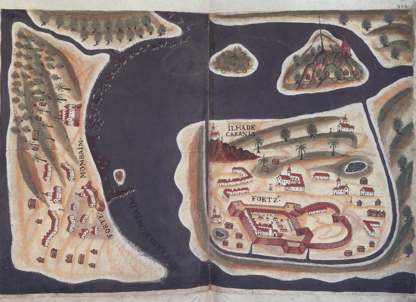
However, a map from the time did survive. Created by Antonio Bocarro in 1635 as part of his report of Portuguese possessions in the Indies, it reveals interesting information (image below): "The Portuguese were better established on the island of Caranja (right) than on Bombay itself, shown on the left, with part of Salsette above. Possibly this is why they were prepared to offer Bombay to the English."
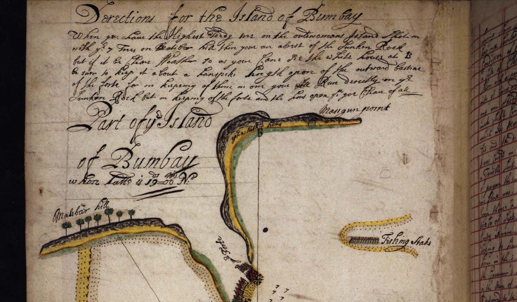
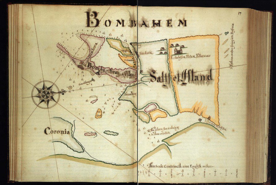
Towards the end of the 17th century, detailed sketches of the harbour of Bombay were made to guide ships, especially to avoid the dreaded "Sunk Rock" off the coast. As for the island of Bombay, its shape itself was disputed. Three maps drawn by William Hack of the Thames School of Chartmakers in London (around 1680) show completely different shapes for the island and coastline. The second of these (image below) shows "many smaller islands, and was perhaps prepared during the monsoon when water lay over much of the land that was dry during the rest of the year."
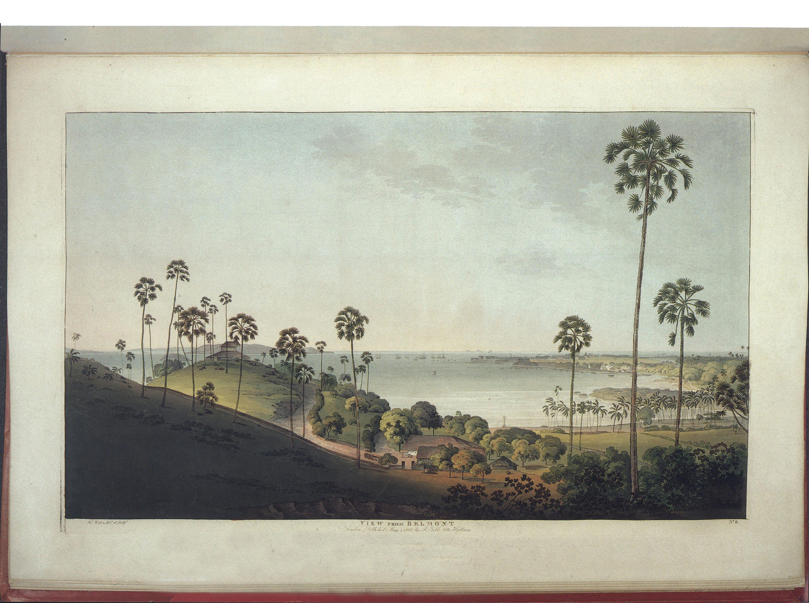
Almost a century later, two Scotsmen living in Bombay between 1766 and 1795, were the first to systematically create accurate landscape illustrations of the city, drawn on the spot. James Forbes, an East India Company civilian, drew for leisure, whereas James Wales, a professional painter, made his for the print market. They also wrote journals detailing Bombay, which then was developing into a peninsula. The below painting by Wales offers a southwards view from Mazgaon hill and depicts the “Bombay Island and the harbour estuary”.
Views and images like these cannot be farther from Mumbai’s reality today. Yet, as Chakravarty’s biodiversity map shows, there can be newer ways to explore cities, especially when seen through ecological and cultural lenses. What type of map would you like for your city?
Image Credits
- Detail of Marg's 1997 cover. Directions for avoiding the "Sunken Rock" while sailing into Bombay harbour. Courtesy The British Library.
- Bombay. By Antonio Bocarro, bound in Historical and topographical account of the Portuguese settlements in the East Indies, Pavia, 1646. Courtesy The British Library, London. Published in Marg Volume 48 Number 4, 1997.
- "Bombahem." By William Hack, circa 1680 Manuscript. Courtesy The British Library, London. Published in Marg Volume 48 Number 4, 1997.
- "View from Belmont", Mazgaon Hill. By James Wales; original drawing 1791-92; from Twelve Views of the Island of Bombay and its Vicinity, published London, 1800. Published in Marg Volume 48 Number 4, 1997.