now 2050most of mumbai island city,Bandra west to Andheri west including Lokhandwala will be under sea,including Airports new and old.
The new projections suggest that much of Mumbai, India’s financial
capital and one of the largest cities in the world, is at risk of being
wiped out. Built on what was once a series of islands, the city’s
historic downtown core is particularly vulnerable.
Over all, the research shows that countries should start preparing now
for more citizens to relocate internally, according to Dina Ionesco of
the International Organization for Migration, an intergovernmental group
that coordinates action on migrants and development.
“We’ve been trying to ring the alarm bells,” Ms. Ionesco said. “We know
that it’s coming.” There is little modern precedent for this scale of
population movement, she added.
Coastal Road (Mumbai)
Videos
Web results
Coastal Road (Mumbai) The Coastal Road is an under construction 8-lane, 29.2-km long freeway that would run along Mumbai's western coastline connecting Marine Lines in the south to Kandivali in the north.
Oct 25, 2019 - Bombay HC has cancelled the environmental clearance for the ambitious Mumbai Coastal Road project and has called it illegal.
May 7, 2019 - 'Destructive futility': 10 reasons why Mumbai's Coastal Road Project should be scrapped A graphic representation of a portion of the proposed ...
Jul 16, 2019 - Mumbai: In a major setback for the Bharatiya Janata Party-Shiv Sena government's Mumbai makeover plans, the Bombay high court (HC) on ...
Oct 23, 2019 - ... pleas challenging the Bombay High Court order which had quashed the CRZ clearances granted to the Rs 14,000-crore coastal road project ...
Web results
Aug 26, 2019 - As Manish Agarwal, partner, (infrastructure), PwC, explained, for a city like Mumbai, this is the only way to get a ring-road type structure.
Mumbai coastal road News: Latest and Breaking News on Mumbai coastal road. Explore Mumbai coastal road profile at Times of India for photos, videos and ...
Oct 24, 2019 - Here are the facts, figures and upcoming developments in the Mumbai Coastal Road, slated to be Mumbai's most ambitious infrastructure ...
Searches related to mumbai coastal road
old photo 1940 of Andheri west "seven bungalows area"; surrounded by sea and salt pans before buildings were built over salt pans between 4 Bungalows and 7 Bungalows

now a concrete jungle

.................................................................................................................................
There also are several smaller islands that lay to the East of the main seven islands:
- Elephanta Island also Known as Gharapuri
- Butcher Island
- Middle Ground
- Oyster Rock
- East Ground
- Cross Island

BOMBAY 1540 -
History
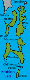
When the Portuguese took possession of Bombay, the seven small islands out of which it had formed had by then partly coalesced. Colaba and Al-Omanis still remained to the South separated by narrow channels. But between the islands of Bombay, Mazagoan and Parel the creeks had silted up.was the only one which always required passage by boat.

This "seven-island kingdom" as some authors wish to call it thus identifying it with the Heptanesia of Ptolemy, was not thickly populated. The inhabitants with the exception of some Mohammedans at Mahim, were mostly Hindus of the Kolis and the Bhandari castes, agriculturists, toddy tappers, gardeners, fishermen.

COLABA RECLAMATION BOMBAY
mm
For the fort in Alibaug, see Kolaba fort. Colaba is a part of the city of Mumbai, India, and also a ... The Colaba Causeway was completed in 1838, and thus, the remaining two islands were joined to the others. Gradually, Colaba became a ...


Bombay harbour 1800's with Bombay fort seen in left

view of Bombay harbour 1800's

Bombay Photo Images[ Mumbai]: [PART-1B](BOMBAY)MUMBAI LIFE/PHOTOS ...

Colaba Causeway construction using timber, view from Colaba island, 1826

Bombay Photo Images[ Mumbai]: 09/01/2011 - 10/01/2011


below:-view of Bombay from malabar hill towards chowpatty to colaba and beyond -1800's
It took over 150 years to join the original seven islands of Mumbai. These seven islands were lush green thickly wooded, and dotted with 22 hills, ...
Colaba Causeway - Wikipedia
https://en.wikipedia.org/wiki/Colaba_Causeway
Colaba Causeway,
officially known as Shahid Bhagat Singh Road, is a commercial street,
and a major causeway or land link between Colaba and the Old ...
District: Mumbai City
Zone: 1
Metro: Mumbai
PIN: 400 005
Colaba - Wikipedia
https://en.wikipedia.org/wiki/Colaba
MOMBAIM (BOMBAY)


BOMBAJA FORT(BOMBAY) 1700
Bombay City Love to Know 1911.:-http://oldphotosbombay.blogspot.com/2010/12/bombay-city-love-to-know-1911.html
BOMBAIA (BOMBAY)-16TH CENTURY MAP

Bombay harbour 1800's with Bombay fort seen in left

view of Bombay harbour 1800's

Bombay Photo Images[ Mumbai]: [PART-1B](BOMBAY)MUMBAI LIFE/PHOTOS ...
Bombay Photo Images[ Mumbai] - blogger
Lithograph of a view of Colaba by Jose M. Gonsalves (fl. 1826-c.1842)


Bombay Photo Images[ Mumbai]: 09/01/2011 - 10/01/2011
oldphotosbombay.blogspot.com
Marine Battalion, Esplanade.-BOMBAY-Artist: Gonsalves, Jose M. (fl. 1826-c.1842) Medium: Lithograph Date: 1826


below:-view of Bombay from malabar hill towards chowpatty to colaba and beyond -1800's

It took over 150 years to join the original seven islands of Mumbai. These seven islands were lush green thickly wooded, and dotted with 22 hills, ...
m


