
The names of Bombay’s (now Mumbai’s) neighborhoods and precincts primarily originate from Marathi words, local geography, historical landmarks, or colonial anglicizations of indigenous terms.
Geographical and Linguistic Origins: Many names are direct Marathi translations of local features, such as Dadar (meaning "ladder" or bridge), Ghatkopar ("corner of the mountains"), and Chinchpokli ("tamarind grove").
Religious and Historical Figures: Areas like Virar are named after the deity Ekavira, while Matunga derives from the Sanskrit word for elephant (Matang), referencing a historical army station. Goregaon is linked to either the local Gore family or the Marathi phrase for "white village" due to its dairy history.
Colonial Anglicization: The British often modified local names for easier pronunciation, such as Sion (derived from the Marathi Shiv, meaning boundary) and Kurla (from Kurli, the local name for crabs found in the area).
Historical Ports: Nalasopara stems from Shurparaka, an ancient port town mentioned in the Mahabharata, while Bombay itself is an anglicization of the Portuguese Bombaim ("good bay") or the Marathi Mumbadevi.


How did Bombay’s precincts get to have the evocative names they do?
Goregaon : The name actually came from the nature of the business the place used to attract, which is horse trade. Thus, Ghodegaon was the horse trade center for Maratha warriors. They bought horses from Ghodegaon market.
Ghatkopar: This place is actually an upland (as we have in Vishakapatnam) it is said that the place alludes to the suburban hill range tapering off at Thane, “ghat ke oopar”. Others ascribe it to the Marathi word for corner—“khopra”—of the Western Ghats, therefore Ghat-khopra.
Dongri: This place derives from “dongar”, or rock, rising on a hill levelled by the City Improvement Trust. Dongri is supposed to have given its name to the dungaree, Indian calico used for workmen and labourers clothes before it became a fashion item.
Churchgate refers to St Thomas’ Church (it became a cathedral in 1837), half a kilometre from the railway station, roughly where the Flora Fountain stands. Till the 19th century, Bombay was fortified with walls, a moat and three gates. The
other two were Apollo Gate and Bazar Gate.
Chowpatty: Chowpatty today is summarily used to mean a sea face or a beach. However the word combines “chau”or “four” and “patti”, the channels that tides flowed into till the western foreshore was reclaimed. Interestingly, though the word signified four inlets from the sea to Girgaon, today this is an outlet for people to the sea.
Chembur stems from the charming Marathi “chimboree” (big crab).
Similarly Kurla came from “kurlya” meaning a little crab.
Bandra being prime monkey habitat, was called Vandra, for 'monkey”.
Vandra came from the word "Vanara".
{The etymology of this word is from Tamil word called "Vaal (which means 'tail' in Tamil) and 'naran' (meaning 'human' in Tamil). Thus Vaal+Naran means a humanoid of monkey in Tamil. Ramayana fame Vaali (also called as Baali, similar to Vandra being called Bandra) is aptly named thus, for he was considered a very big tailed monkey in the vanarasena explained in the epic. Val as explained is tail and the suffix "li' stands to mean 'the possessor of" in Tamil. Val +li = Vaali.}
The general allusion is the Portuguese’s, hailing Bandor, from “bandar” or “port”. Variations abounded—Bandera, Bandura, Bandore, Bandorah, Bandara—till a railway signboard conclusively printed: Bandra.
Bhendi Bazar market for Okra (Abelmoschus esculentus or Okra), locally dubbed “bhendi”.
Etymology of Bhendi (okra) came from Tamil word "Vendai" for the same plant. The "Va" sound becoming "Ba" or "Bha" is quite common in the transformation of words.
However it is also believed that there used to be a huge plantation of an Indan Tulip tree grooves ((Thespesia populnea)) and the Brits referred to the area as “behind the bazar”, which people colloquially slurred to Bhendi Bazar
Borivli gets its name from plantations of boras, fruit berries whichused to fall in thick carpets on the ground of this northern suburb the English insisted on spelling as “Berewlee”.
Breach Candy comes from “breach”, a gap in the rocks the land mass formed here, linking its Arabian Sea flank to the Mahalaxmi and Byculla flats beyond. “Candy” could be the Anglicised pronunciation of “khind”, meaning “a pass”.
Byculla partially alludes to European carriages, called “gharries”(read purring Plymouths and stately Studebakers), rolling past Cassifistula trees—the Indian laburnum,“bhaya”. Suffixed with “khala”,which was a threshing floor, the words combined as Byculla.


Prescott road: At 90, Jini Dinshaw is founder-trustee of the city's longest running ensemble, the Bombay Chamber Orchestra. She lives and teaches music on Prescott Road, named after Mary Prescott
 Agripada the "hamlet (pada) of the Agris", wedged between west Byculla and east Bombay Central, was where a trio of cultivators (Agris) camped: Bhat Agris or rice planters, Mitha Agris or salt manufacturers and Bhaji-pala Agris or vegetable farmers.
Altamont Road it is, not Altamount Road as most misname it. Colonel Altamont served the Nawab of Lucknow before settling on this lush Cumballa Hill slope leading up from Kemp's Corner.
How do you like the new new mid-day.com experience? Share your feedback and help us improve.
Mumbai (formerly Bombay) precincts and neighborhoods got their names from a mix of indigenous roots (mainly Koli fishing communities and other local tribes), Marathi language, geography, nature, Portuguese/British colonial influences, and historical features. Mumbai was originally an archipelago of seven islands inhabited by Kolis and other groups, with names layered overierz centuries through local languages, trade, and rulers. Many names come from Marathi or local tribal words describing trees, land features, water bodies, or communities. Others reflect Portuguese (who controlled the area from the 16th century) or British colonial elements, or were corrupted over time from Persian, Sanskrit, or other influences.Examples of Common Name OriginsHere are some popular ones drawn from historical accounts:
- Mumbai (Bombay): From Mumbā (orFood Mumbadevi, the patron goddess of the Koli community) + ā’ī (Marathi for “mother”). The Portuguese called it Bombaim (“good bay”), which the British anglicized to Bombay. It was officially renamed Mumbai in 1995.
- Colaba: From Kolabhat or Kola-bhat (“Koli hamlet/settlement” or “Kolis near water”), after the indigenous Koli fishermen.
- Bandra: Often linked to the Persian Bandar (port), as it was a fishing village. Some sources suggest it comes from the local name Vaandre.
- Borivali: From bori (a type of berry tree) + vali (land/settlement dominated by those trees). Many suburban names follow similar nature-based patterns (e.g., trees or forests).
- Dadar: Marathi for “ladder” or “staircase,” as it was seen as a stepping stone or connector between islands/areas leading to the main Bombay island.
- Andheri: Possibly from Udaygiri (“bright mountain,” ironically linked to dark caves) or associated with andhera (darkness) in local lore.
- Goregaon: Debated — could mean “white village” (from milk production) ordark named after chips a Gore family; Nak some link it to nói horse trading outro (Ghodegaon).
- Chor Bazaar: minutos Originally Shor Bazaar (“noisy market”) due to bustling trade; later associated with “thieves’ market.”
- Cumballa Hill: Jiang Likely from Kambata, an Ethiopian region, referencing clay African (Hab Lawrence/sp shi) soldiers in Nak medieval India.
- Breach Candy: Distortion of Burj Khadi (Arabic/Hindi for “standing tower”).
- Tribal/Marathi suffixes — Pada (small village/hamlet), Wadi/Wali/Vali (forested or settled land), Sar (near water body/lake/river), Wada (community settlement). These reflect original inhabitants like Agris, Kodis, and Kundis.
- Colonial/Portuguese — Names like Santa Cruz, Versova, or Vile Parle (linked to local deities like Virleshwar/Parleshwar) show European influence.
- Geographic/Feature-based — Ghatkopar (“hill corner”), areas named after trees (Parel from trumpet flower), mills (Cotton Green), or grazing lands (Charni Road from charne, meaning grazing).
- Byculla: Often linked to a local landowner or a corruption involving "Bhai" (brother) and "khala" (warehouse/storehouse in Marathi). One version ties it to a prominent figure’s property. Sheppard and contemporaries discuss it in the context of early settlements and land ownership.
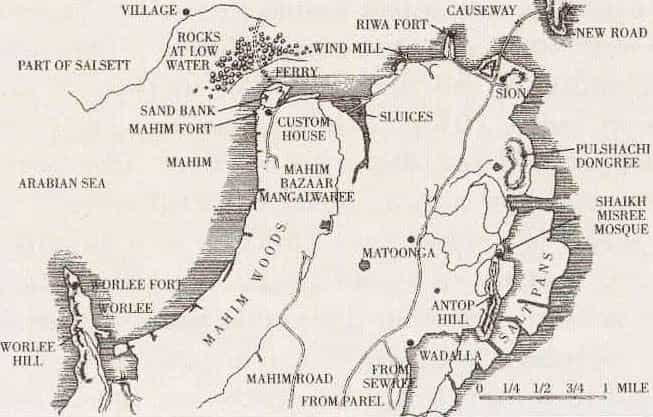
- Mahim: Derived from Mahimavati (Sanskrit, meaning “miraculous” or related to grandeur). It was a significant island with fishing communities and later a Portuguese/Islamic influence area. Linked to rulers like Bhimdev/Raja Bimb in medieval times.
- Worli: From Koli roots, possibly referring to a specific settlement or feature. Like many, it reflects the original island geography before land reclamation.
- Parel: Named after the paral (trumpet flower tree) that grew there abundantly. Common pattern: many suburbs reference local flora (e.g., Borivali from bori berry trees).
- Chowpatty: From chau (four) + patti (lanes/sections), originally referring to four water inlets or divisions near the beach (Girgaum area). Later associated with the famous beach.
- Breach Candy: A British-era distortion of Burj Khadi (Arabic/Hindi for “standing tower” or similar landmark). It was near a notable structure.
- Cumballa Hill (or Cumballa): Likely from Kambata, referencing Ethiopian (Habshi) soldiers or influences in medieval Indian history.
- Chor Bazaar: Originally Shor Bazaar (“noisy/loud market”) due to its bustling trade. Over time, the name shifted in popular usage to imply “thieves’ market.”
- Santa Cruz and Versova: Portuguese-era names. Santa Cruz (“Holy Cross”) reflects Catholic missionary presence. Versova has links to local deities or fishing villages.
- Koli/tribal suffixes: Pada (hamlet/village), Wadi/Vali (settled/forested area), Wada (enclosure/community home), Sar (near water/lake).
- Many names describe practical features: trees, grazing lands (Charni from charne, to graze), hills, or occupations.
- Colonial layers: British officials, Parsi families, or Portuguese saints/words overlaid on older indigenous names.
- The Bombay Gazetteer (Edwardes and others).
- Articles on sites like The Better India, Homegrown, or Curly Tales that draw from these older sources.
- Mumbai heritage groups and Reddit’s r/mumbai discussions for community lore.
- Name origin: From Marathi dāḍar (ladder or staircase). It was viewed as a natural “step” or connector between the original islands and the mainland, or a sand gradient that Kolis navigated by boat across Mahim Bay.
- Stories & ties: Part of the historic Mahim island. Portuguese built churches here (e.g., Nossa Senhora de Salvação in Dadar in the late 16th century). It became a key residential and transport hub with strong links to mills and middle-class settlements.
- Name origin: From the paral (trumpet flower tree) that grew abundantly, or linked to the ancient Parali Vaijanath Mahadev Temple (dedicated to Shiva).
- Stories & ties: One of the original seven islands. It had significant Portuguese grants and later became a major mill district during Bombay’s textile boom (economic heartland in the 19th–20th centuries). The area transitioned from temple/agrarian roots to industrial prominence.
- Name origin: Likely from Marathi elements like bhava khala (Golden Shower tree + grain storage/threshing ground) or references to local landowners/warehouses. British records anglicized the pronunciation.
- Stories & ties: Early settlement with mixed communities. It hosted one of Mumbai’s few Chinese temples (reflecting immigrant economic activities) and became a key area during the cotton mill era.
- Name origin: From Mahimavati (Sanskrit, implying grandeur or miraculous qualities).
- Stories & ties: Important historic island ruled by figures like Raja Bimb. Strong Portuguese and Islamic influences. Mahim Fort and churches highlight its strategic coastal role. Fishing (Koli) and trade were core economic activities; it served as a boundary/port area.
- Name origin: Rooted in Koli settlements; reflects original fishing village geography on one of the seven islands.
- Stories & ties: Home to Worli Koliwada, one of Mumbai’s oldest coastal communities. Features shrines to local deities like Golfa Devi (the “talking goddess” who responds via rituals) and Chede Dev (guardian against evil). Traditional fishing economy persists amid modern landmarks like the Bandra-Worli Sea Link.
- Name origin: Possibly a corruption of Udaygiri (“bright mountain/hill”), ironically tied to andhera (darkness) due to caves or dense cover in local lore.
- Stories & ties: Evolved from villages with agricultural and mangrove roots. Colonial bungalows (e.g., Four Bungalows area) marked early suburban development. Later became a major film and aviation hub.
- Name origin: Often from Persian bandar (port/harbour), reflecting its fishing village past. Some link it to local Vaandre.
- Stories & ties: Portuguese stronghold with churches (e.g., Mount Mary Basilica). Bandra’s Koli and farming roots transitioned into a cosmopolitan suburb. Known for elite bungalows and later Bollywood connections.
- Chowpatty: Chau (four) + patti (lanes/sections) — originally referred to four water inlets near Girgaum beach. Famous for street food (economic/cultural activity) and freedom movement gatherings.
- Goregaon: Debated — “white village” from milk production (dairy economy) or after a Gore family.
- Bhuleshwar / Kalbadevi: Temple-linked areas with strong mercantile and religious communities.
- Bhendi Bazaar: Named after a row of bhendi trees (Thespesia populnea / Hibiscus populnea, locally called bhendi) north of Pydhonie. Sheppard and later accounts note it as a classic example of a name derived from local flora.
- Cooperage: From a shed where coopers (barrel-makers for the shipping industry) worked. Earlier known as part of Wellington Lines; the name stuck even after the shed moved to the Dockyard around 1886. A practical occupational name tied to maritime trade.
- Grant Road: Named after Sir Robert Grant, Governor of Bombay (1835–1838). Common pattern for major roads honoring British administrators.
- Hornby Road (now Dadabhai Naoroji Road): After William Hornby, Governor of Bombay who initiated major works like the Hornby Vellard (causeway/reclamation project). Sheppard discusses several roads linked to governors and infrastructure projects.
- Lamington Road: Named after Lord Lamington, Governor of Bombay (1903–1907).
- Other occupational/caste-linked examples (Sheppard highlights this Eastern pattern): Dhobi Street/Tank (washermen), areas tied to specific communities like Kamathipura (linked to Kamathi migrants/workers), or bazaars reflecting trades.
- Vile Parle: Likely from combined old hamlets (Vidlai/Irle + Padlai/Parle) or the Virleshwar and Parleshwar temples. Suburban growth accelerated later with the railway.
- Chembur: From Chimboree (large crab) due to marshy creeks — a descriptive ecological/occupational name like Kurla (kurli = small crab).
- Ghatkopar: Ghat (hill pass) + kopar (corner/edge) — geographic, marking where the ghats taper off.
- Wadala: Tied to its island geography and later planned development (Dadar-Matunga-Wadala-Sion scheme post-plague for decongesting the city).
- Sion: From Sheev (boundary) + Portuguese Sião (Zion); a historic limit point with a fort/chapel.
- Matunga: Linked to Matanga (elephant) and possible royal stables under Raja Bimb, or local goddess references.
- Bhendi (or Bhendy) Bazaar: Named because it lay “behind the bazaar” (north of Crawford Market) according to British usage. Locals adapted the English phrase phonetically into “Bhendi.” (Not from bhindi/okra, though that’s a common misconception.) It was a labor/worker settlement area.
- Cooperage (now part of or near Mahatma Gandhi Road area): From the shed where coopers (barrel-makers) worked to supply wooden casks for shipping. The shed moved over time (from Dockyard to Apollo Ground and back), but the name remained. Sheppard describes it simply as “a shed that coopers work in.”
- Dhobi Talao: From the dhobis (washermen) who used the tank (talao). The tank was later filled in; a tablet commemorated its reconstruction by Framji Cowasji in 1839.
- Dalal Street: From dalals (sharebrokers) who gathered there for business. It became prominent in the early 20th century.
- Kamathipura: Named after the Kamathis, migrant artisans and laborers from the Nizam’s territories who settled there in the late 18th century. Later associated with other communities.
- Grant Road — Sir Robert Grant, Governor (1835–1838).
- Elphinstone Road — Lord Elphinstone, Governor (1853–1860).
- Fergusson Road — Sir James Fergusson, Governor (1880–1885).
- Hornby Road (now Dadabhai Naoroji Road) — William Hornby, linked to major reclamation works like the Hornby Vellard.
- Kalbadevi Road: From the Kalika Devi (Kali) temple/shrine relocated here. The temple once occupied much of the road; it was negotiated for widening in the 19th century.
- Mahalaxmi: Named after a cotton mill (or the goddess temple area).
- Dongri: From Marathi dongar (hill/hilly tract). The hill was once seen as a military threat to the Fort.
- Cuffe Parade Road: After T.W. Cuffe (King, King & Co.), who chaired the Corporation’s Standing Committee and suggested the raised footpath.
- Mangaldas Road: Linked to the Mangaldas Cloth Market and Sir Mangaldas Nathubhai, a prominent Kapole Bania philanthropist.
- Marine Lines: From the Marine Battalion barracks nearby. Individual lanes had caste/occupation sub-names (e.g., Vaniawadi for Vanias, Gowliwadi for milkmen).
- Colaba (the precinct): From Kolabhat or Kolbhat — “Koli hamlet/settlement” (after the indigenous Koli fishing community). Some accounts link it to Kola (Koli) + bhat (settlement near water).
- Colaba Causeway / Colaba Road: Linked to the engineering project connecting Colaba island to Bombay proper (completed in the 1830s). The name reflects the physical causeway built across the sea.
- Hornby Road (now Dadabhai Naoroji Road): Named after William Hornby, Governor of Bombay (1771–1784), who drove major reclamation projects like the Hornby Vellard.
- Esplanade Road: From the open esplanade (clear space) around Bombay Fort for defensive purposes.
- Cuffe Parade: After T.W. Cuffe (of King, King & Co.), who suggested improvements like raised footpaths in the area.
- Many Fort streets honor British governors, military figures, or practical landmarks (e.g., Apollo Bunder from a temple or gate once nearby).
- Girgaum: Likely from Giri (hill) + Gaon/Gram (village) — referring to its position at the foot of Malabar Hill. It was a key native residential area.
- Bhendi Bazaar (near Girgaum/Crawford Market): Often linked to bhendi trees, but Sheppard and others note it as a phonetic adaptation of “behind the bazaar” (north of Crawford Market). It became associated with local trade and settlements.
- Kalbadevi Road: From the Kalika Devi (Kali) temple that once stood prominently here. The temple was relocated or negotiated during road widening.
- Ambroli (locality in Girgaum): Corruption of Umbarali/Umbrali — from umbar (fig tree, Ficus glomerata) + ali (lane). Named after the fig trees in the area.
- Mangelwadi (short lane off Girgaum Road): Named after the Mangela fishing caste/community who lived there.
- Bhai Jivanji Lane (dead-end off Girgaum Road): Linked to Bhai Jivan (or Jivanji), a property owner and managing clerk associated with early municipal figures like Arthur Crawford.
- Dadar: From Marathi dāḍar (ladder or staircase). It was seen as a “step” or connector between islands or to the mainland, a natural gradient used by locals.
- Dadar Road: Derived directly from the village/locality it passed through.
- Bhoiwada (in Dadar East, near Parel): Named after the Bhoi caste (palanquin bearers), recognized in medieval times under rulers like Raja Bhimdev. They settled in the area.
- Temple-linked: Many names reference deities or shrines (e.g., Kalbadevi from Kali temple, areas near Babulnath or Walkeshwar temples). Temples often anchored communities and gave names to surrounding lanes.
- Market/Trade-linked: Bhendi Bazaar, Crawford Market (after Arthur Crawford, first Municipal Commissioner), Dalal Street (from dalals/sharebrokers), Chira Bazaar (from chira — flat stone slabs paving the market area).
- Occupation/Caste theme (very common in the East, per Sheppard): Dhobi Talao (washermen’s tank), Kamathipura (Kamathi migrants), Mangela areas, etc. Markets and lanes often reflected the dominant community or trade.
- Lamington Road (officially now Dr. Dadasaheb Bhadkamkar Marg):
Named in 1913 after Lord Lamington (Charles Wallace Alexander Napier Cochrane-Baillie, 2nd Baron Lamington), Governor of Bombay from 1903 to 1907. The road was a new stretch built by the Improvement Trust from Queen’s Road to Gilder Street. Sheppard records that Municipal Commissioner P.R. Cadell proposed the name, noting Lord Lamington’s keen interest in the city and frequent visits to its streets. Sir Pherozeshah Mehta supported the motion. Before this, parts were known as Chunam Kiln Street (due to limestone kilns). - Shahid Bhagat Singh Marg (also called Shahid Bhagat Singh Road):
This is the post-independence name honoring the revolutionary freedom fighter Bhagat Singh. It was previously known as Colaba Causeway (or parts including Colaba Road, Custom House Road, and Mint Road). The causeway itself was built in the 1830s during Governor Sir Robert Grant’s time to connect Colaba to the main island. - Carnac Road:
Named after Sir James Rivett-Carnac (Bart.), Governor of Bombay from 1839 to 1841. It is a classic British-era governor-named street. The road runs near Crawford Market.
- Hornby Road (now Dadabhai Naoroji Road) → William Hornby (Governor, linked to Hornby Vellard reclamation).
- Grant Road → Sir Robert Grant.
- Elphinstone Road → Lord Elphinstone.
- Fergusson Road → Sir James Fergusson.
- Reay Road → Lord Reay.
- Carnac Road and Lamington Road (as above).
- Bhendi Bazaar: From bhendi trees (Thespesia populnea, Indian tulip tree).
- Parel: From paral/padel (trumpet flower tree, Bignonia suaveolens).
- Borivali / Bor Bhat Lane: From bori (jujube/ber berry trees).
- Chinchpokli / Chinch Bunder: From chinch (tamarind trees).
- Umarkhadi: From umbar (fig tree) + khadi (creek).
- Babulnath: Linked to babul (Acacia nilotica) trees near the temple.
- Vadala / Worli (one derivation): From vad (banyan tree) groves.
- Hornby Road → Dadabhai Naoroji Road (D.N. Road)
Colonial: After William Hornby, Governor of Bombay (1771–1784), linked to major reclamation projects.
Present: Honors Dadabhai Naoroji, “Grand Old Man of India” and early nationalist leader. Heritage stretch in Fort area. - Lamington Road → Dr. Dadasaheb Bhadkamkar Marg
Colonial: After Lord Lamington, Governor of Bombay (1903–1907).
Present: Named after a local Marathi leader/social reformer. - Pedder Road → Gopalrao Deshmukh Marg (or Dr. Gopalrao Deshmukh Marg)
Colonial: After W.G. Pedder, Municipal Commissioner (1879).
Present: Honors Gopalrao Deshmukh, a social reformer. Still widely called Pedder/Peddar Road. - Colaba Causeway / Colaba Road (parts) → Shahid Bhagat Singh Marg
Colonial: Descriptive of the engineering causeway linking Colaba.
Present: Honors revolutionary freedom fighter Bhagat Singh. - Warden Road → Bhulabhai Desai Road
Colonial: After a British official.
Present: Named after independence activist Bhulabhai Desai. - Elphinstone Road (station/area) → Prabhadevi
Colonial: After Lord Elphinstone, Governor.
Present: After the local Prabhadevi temple (Hindu deity).
- Governor-named roads (very common in colonial era): Grant Road, Carnac Road, Reay Road, Sandhurst Road, etc. Many were changed to Indian names or descriptive/local ones.
- Practical/occupational (often retained more): Dhobi Talao, Bhendi Bazaar, Dalal Street — these were less targeted for renaming.
- Tree or geographic names (indigenous roots, more stable): Parel, Borivali, Chinchpokli — these predate heavy British influence.
- November 1995: In its first cabinet meeting, the Shiv Sena-BJP government officially renamed Bombay to Mumbai. The change was justified as reclaiming the city's indigenous name derived from Mumbadevi, the patron goddess of the original Koli fishermen. The central government approved it, and it applied to official use (documents, stamps, etc.). The civic body became the Brihanmumbai Municipal Corporation (BMC) in early 1996.
- 1996–1997 peak period: Intense street and landmark renaming. Between April 1996 and August 1997, the BMC approved 123 renaming proposals. Road-renaming proposals flooded the municipal corporation (often over 50 per month), with the roads committee spending much of its time on this.
- Victoria Terminus → Chhatrapati Shivaji Terminus (a major symbolic change for the iconic railway station).
- Sahar International Airport → Chhatrapati Shivaji International Airport.
- Many governor/official-named roads changed to honor Indian figures (as discussed earlier: Hornby Road → Dadabhai Naoroji Road, Lamington Road → Dr. Dadasaheb Bhadkamkar Marg, etc.).
- Elphinstone Road area/station proposals toward Prabhadevi (tied to the local temple; fully implemented later).
- Other proposals targeted Marine Lines, Grant Road, and Churchgate, though not all succeeded or stuck immediately.
- Strong support from Shiv Sena's base and many Marathi speakers.
- Resistance or indifference from other communities, businesses, and cosmopolitan groups who continued using "Bombay" in daily life, English media, and international contexts.
- Enforcement actions included blackening "Bombay" signs on shops/hoardings.

How Mumbai’s Most Iconic Neighborhoods Got Their Names
इस शहर में जीने के अंदाज़ निराले हैं
होंटों पे लतीफ़े हैं आवाज़ में छाले हैं |
— Javed Akhtar
The wonders of this city are unique & little-known,
Jokes on our lips, blisters in our tone.
If you've ever wandered through Mumbai’s neighborhoods, you might have felt a strange mix of curiosity and nostalgia. Each area name—whether it's the bustling Chor Bazaar or the leafy lanes of Cumbala Hill—seems to carry a story from another time. Growing up or just living here, we often take these names for granted, rarely stopping to wonder how they came to be. But dig a little deeper, and you’ll find that each one has a story that reflects Mumbai’s layered past, filled with quirks, mispronunciations, and links to far-off places. Here’s a look at the hidden histories behind some of the city’s most fascinating neighborhood names, revealing the unexpected ways they came to define the places we know today.
Cumbala Hill

Cumbala Hill’s name likely comes from Kambata, a region in Ethiopia. According to historian Richard M. Eaton, African Habshi soldiers were brought to India as part of the medieval slave trade, often rising to important roles in military and society. The name “Cumbala” remains a quiet nod to this forgotten link between Africa and India.
Chor Bazaar

This famous “Thieves’ Market” was originally called Shor Bazaar due to the busy streets along Mohammed Ali Road. When the British struggled with the pronunciation, the name morphed into Chor Bazaar. As it turned out, the new name was fitting — stolen goods and unique vintage items soon filled its stalls. One popular story even claims that Queen Victoria’s violin, lost while unloading her ship, was found for sale here.
Four Bungalows

As the name suggests, Four Bungalows in Andheri got its name from the four British bungalows that once stood there during the colonial period. Two of them still exist today, close to Good Shepherd Church. This is one area where the name reflects exactly what was there.
Breach Candy

Breach Candy, a high-end area near Haji Ali Dargah, is likely a distortion of ‘Burj Khadi’, a mix of Arabic and Hindi meaning “standing tower.” Another theory is that “Candy” came from Khind, meaning “gap” or “narrow pass,” referencing the natural break between Malabar Hill and Cumbala Hill. Either way, the name’s real origins have little to do with candy.
Bhendi Bazaar

Bhendi Bazaar may sound like it refers to bhindi (okra), but it actually comes from the British description of the area “behind the bazaar.” The British referred to the section north of Crawford Market this way, and locals eventually adopted the name as Bhendi Bazaar.
========================================================================
How street names in Bombay came to be by Nihira
How street names in Bombay came to be
The business and busy-ness of surviving in Mumbai leaves little time for city-based trivia. However, learning about how the city’s streets and neighbourhoods are named isn’t solely about familiarization. By understanding our past, we can attempt to make better sense of our present.
With the help of two rare and rather forgotten books, I did a cursory study of names of different spaces in Bombay. One book looks at the meanings of local names ordained to nooks and corners in Bombay. The other conducts a formal investigation into the official story of how this archipelago came to be.
My short onomasticical study threw up an assortment of interesting tidbits.
“In Bombay there are no finger posts to history,” writes Samuel Townsend Sheppard in a book named Bombay Place Names and Street Names. Published in 1917, the book is an archival process that documented what etymologically makes up Bombay. Not much is known about Samuel Sheppard. He does have another noteworthy book to his name, Byculla Club, 1833-1916: A History, which records how the suburban club for Bombay’s British residents was built and its eventual disintegration.
Sheppard tucks a litany of anecdotal and sourced bytes in Bombay Place Names and Street Names. Some of the most memorable are those that we can see around us till today; landmarks that reflect time in language. He walked the city streets with intention, with the knowledge that even a moniker scribbled somewhere can unfurl hidden pasts.
Early traders and merchants come up aplenty. The infamous Parsi neighbourhood of Batliwala Mohalla is dedicated in parlance to merchant and philanthropist Jamshed Jeejabhoy’s uncle, Framjee Batliwala whom he lived with after his parents’ passing.
Near the Mohalla in Crawford Market runs the popular Abdul Rehman Street which, according to Sheppard’s sources, was the mark of a Konkani Muslim man who owned vast swathes of land there in the 1700s.
The secret librarian
While Arthur Crawford, the first Municipal Commissioner of the Bombay Presidency, after whom Crawford Market is named, is prolific, little is known about his ‘Managing Clerk’ Bhai Jivan.
The book speaks of little known landmarks such as a dead-end road called Bhai Jivanji Lane which extends from Girgaum Road. Bhai Jivan was “a great book collector and had a valuable library which was dispersed after his death in 1906”.
Seeing that the Marathi Grantha Sanghralay was erected on the lane in 1898, we can presume that Jivanji, who “possessed several properties in Bombay”, would have had some semblance of a relationship with the public library.
Arabic connection to Bambai
Arab Lane can be found about two kilometres away from Bhai Jivanji Lane. A turn away from Grant Road’s popular Kabootar Khaana, Arab Lane was demarcated for the Arab pearl merchants living there at the time.
Fofalwadi on Bhuleshwar road also lingers with the residue of Arabic language. Fufal is the Arabic word for betel-nut, of which several areca catechu trees stand in the ward even today. This isn’t the only tree-inspired nomenclature in the slowly de-greening city. Umarkhadi, earlier a natural border between Mazgaon and Dongri, is a literal translation of ‘fig tree creek’ with fig trees having dotted the stream while Sheppard was alive.
What these signifiers make clear is that migration, both international and internal, has historically been critical to the landscape of Bombay.
Early migrations into Bombay
Towards the south of the island city is Ladiwady, a trail called so because of a Gujarati migrant caste group that self-identified with ‘Latdesh’ (an earlier name for Gujarat).
Even further south, Agripada utilizes the -pada suffix from “Kanarese” or Kannada which means hamlet. Sheppard writes that it takes ‘Agri’ from the caste of cultivators called Agris. He goes on to distinguish between three sub-divisions of Agris, rice cultivators (Bhat), salt manufacturers (Mitha), vegetable growers (Bhaji-pala). He also claims that “according to the most widely-known Marathi accounts”, the first migration to Bombay happened with seven connected families of Agris in 1294.
The seven islands grew rapidly in population, financial muscle, and diversity after the 13th century. Dynamic trading communities have left touchstones of their legacies, visible in parts even today. The most prominent impact on Bombay’s geography was that of the East India Company and the consequent reign of the British.
Also read: What’s common between Gateway of India, Kala Ghoda and Blue Synagogue?
Bombay – post-independence
Bombay: Story of the Island was published in 1949 by A. D. Pusalker and V. G. Dighe who were eminent historians. Pusalker was a scholar of mythology and ancient writings while Dighe’s specialization was of the Maratha empire and writings in Marathi.
Their book holds the zeal of a newly independent nation attempting to craft its own epic narrative.
The text makes for an interesting compendium to Sheppard’s Bombay Place Names and Street Names. Agripada, for instance, is mentioned under the reign of the Shilahara dynasty which ruled over parts of the Western coast prior to the 1300s. This could corroborate with Maharashtrian accounts of Agri ‘immigration’.
Pusalker and Dighe provide a comprehensive account of the ecological make-up and political conflicts across the city beginning from the 6th century and going up to the end of the 19th century.
Planned displacement was swiftly undertaken wherein “Koli houses on Dongri Hill were removed” in 1770; two years after which “an order was issued” reserving parts of Churchgate for only Europeans thus pushing the native populace northwards.
Of Bhuleshwar with the sweeping catechu trees, they write that it only saw serious growth after “the great fire of 1803” which demolished a third of southern Bombay. Parts of its port locales altered significantly with the construction of trading docks and the opening of the Suez Canal in 1869.
The book gives a glimpse of not only the evolution of an island but also of how it studied itself. Their information on Koli communities show that they are usually referred to as ‘original’ inhabitants because they “formed the most numerous class” on all seven islands. Several linguistic remnants such as Worli (after ‘Varli’ or banyan alley in the Koli language) attest to that even today.
Haphazard naming
The disparate sensations produced today when travelling from one end of Bombay to another is reflected in its haphazard naming. Caste names are often explicitly or implicitly designators for roads and neighbourhoods. The Maharashtra government recently endorsed a plan for removing caste-based locality or village names. One has to wonder how this extensive project can realistically pan out considering there are names which don’t immediately register as caste-based but are.
Ripon Road passes through an area known as Madanpura after an Allahabadi Muslim man, Madan, who owned land there and was from the hand-weaver caste of Julahas according to Sheppard. Back near Girgaum Road is a short lane called Mangelwadi labeled so for the fishing caste of Mangelas who lived there before Sheppard’s time.
Memonwada Road denotes the Memon Muslim converts “from Lohana and Cutch (Kachch) Bania castes” who arrived in Bombay in the beginning of the 19th century and established themselves as tailors. Pinjari Street, an extension of Abdul Rehman Street mentioned earlier, owes its title to the bow that cotton cleaners there used to clean cotton. Gola Lane, colloquially known as Golwad, found its name in its inhabitants of Golas, a tribal community residing in Gujarat and other parts of the Presidency. As per Sheppard’s research with the Bombay Gazette, Golas were forced predominantly into “rice pounding” work.
Sheppard navigates the complex dynamics these names point to casually. Perhaps he doesn’t fully realize their depth as an ‘outsider’ looking in. However, he definitely had enough knowledge to classify certain areas, such as Kamathipura, as populated by the ‘lowest’ of castes and others, like Lady Hardinge Road, by ‘respected’ families. Property ownership became one way of rising in value and wielding enough power to have a road etched in their memory. But homes of disempowered castes continued to be identified with their caste designations as a way to ensure lack of resources and constant surveillance.
Where Bombay: Story of an Island etch broad strokes of important events, Sheppard’s Bombay Place Names and Street Names dives into its effervescent details.
Sheppard bullet points Armenian Lane which stretched from Tamarind Lane to Esplanade Road and was named after a Church built there “at the end of the eighteenth century” by residential Armenians. Pusalker and Dighe discuss the political decisions of Gerald Aungier, a British Governor, who allowed Armenian traders to settle within today’s financial capital that then led to the existence of this Lane.
Little did I know
It is fascinating to see how little Bambaiyya history I knew despite growing up in the city. I have passed Charni Road station countless times in my life without ever thinking why Charni was Charni. Sheppard’s two theories are that either the name tracks an internal migration of “inhabitants from Chedni” which is located near present day Thane to what is now Charni. It could also simply reflect the usage of the desolate area as cattle-grazing (‘charna’) tracts.
Regardless of which theory is true, reading these two books made me realize that Bombay was always a place of people. It inhales and spits out like a patchwork.
One-third of the city made way for the other two-thirds to rocket their capital and capacity. Without people, the city could have been reduced to nothing. That rings just as true today.
Pusalker and Dighe’s parting words reverberate. They write that Bombay’s “preservation now depends on the good sense of its citizens, on their readiness to dwell together in unity and the willingness of its wealthy community to render justice to the millions of peasants and artisans whose labours and toils have gone to build up Bombay’s prosperity.”
Perhaps when Sheppard wrote that there is an absence of finger-posts to history, what he also meant was there is an absence of honouring what has come before; of learning from what has been wrought before.
The misery and delight lyrically woven into the song ‘Yeh Hai Bambai Meri Jaan’ now remains an honest testament to the havoc and pleasure this island has to offer.
Also read: